
‘Abnormally large’ plume of Saharan dust makes it to the Caribbean, to reach South U.S. this week
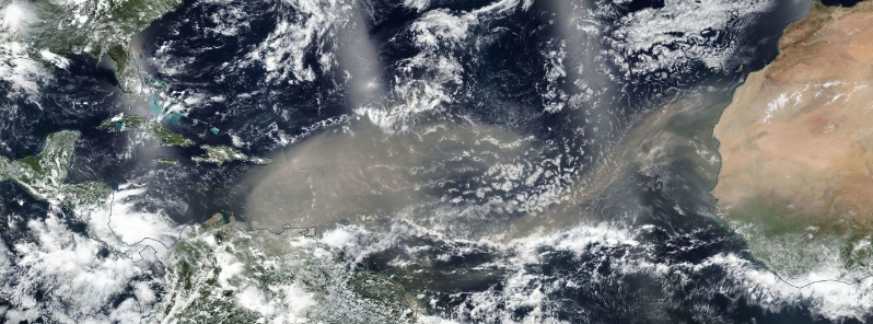
Image credit: NASA/NOAA Suomi NPP/VIIRS Acquired June 21, 2020.
A massive dust cloud from the Sahara continues its westward progression and has moved over the Lesser Antilles, the eastern Caribbean Sea, and Puerto Rico as of June 21, 2020. The dust plume, which is described by scientists as an abnormally large cloud, is forecast to reach parts of the Gulf Coast and Deep South later this week.
The Saharan Air Layer dust outbreak started to emerge off western Africa last week and has now trekked over 4 800 km (3 000 miles) across the Atlantic Ocean to the eastern Caribbean Sea.
Each year, the Saharan dust tracks as far west as the Caribbean Sea, Flordia, and the Gulf of Mexico, which is an 8 000 km (5 000 miles) long journey.
The dust has now moved over the Caribbean, with surface reports at Port of Spain in Trinidad and Tobago indicating a drop in visibility below 0.8 km (0.5 miles) for several hours.
At San Juan in Puerto Rico, the surface visibility dropped to 11 km (7 miles).
Image credit: NOAA/GOES-16, UW-CIMSS (True Color RGB image)
"According to scientists that I have gotten some information from, they're saying this is an abnormally large dust cloud," AccuWeather senior meteorologist and lead hurricane expert Dann Kottlowski said.
"One of the things I noticed from this is the dust started coming off the coast of Africa several days ago, in fact maybe over a week ago. And it's still coming. It's almost like a prolonged area of dust."
Ok, last dust pic for today and this one is perhaps the most incredible yet. The comparison photos were sent to me from Mirco Ferro who lives in St. Barthelemy. Check the dates in the photos (top is from March) – both are unfiltered or altered in any way. #SAL #DUST pic.twitter.com/FBwOG5ly1E
— Mark Sudduth (@hurricanetrack) June 21, 2020
Serious Sahara Dust all the way in Trinidad in the sky today.#SaharanDust pic.twitter.com/oWxk7Q8dkq
— Russell Cris Muñoz (@russellmunoz) June 21, 2020
Dense Saharan dust is tracking through the Caribbean and will reach the U.S. Gulf Coast later this week. Here are some of the impacts we might see from the dust by the weekend: https://t.co/PQW8IyqAeQ pic.twitter.com/M2O30xLi9m
— The Weather Channel (@weatherchannel) June 22, 2020
Dust moving from the Sahara to the Gulf Coast is common during the months of June, July, and sometimes early August.
"This is the dusty time of the year," Kottlowski added, noting that a stronger-than-normal or at least, a very active easterly jet from Africa might have contributed to spurring the dust plume.
As the dust is carried across the Atlantic, it tends to subdue tropical development.
The Saharan dust is forecast to continue barrelling westward through the Caribbean Sea, then reach parts of the Gulf Coast and Deep South this week.
The particles can cause hazy skies, as well as spectacular sunrises and sunsets in the Caribbean Islands, South Florida, and the Gulf Coast.
A computer model forecast of atmospheric dust for the next 10 days. The plume of Saharan dust is expected to move over the Southeastern US next week. The dust will be primarily at higher altitudes, so the main impact will be some especially colorful sunrises sunsets pic.twitter.com/bBzFp06lCu
— NWS Eastern Region (@NWSEastern) June 19, 2020
Commenting rules and guidelines
We value the thoughts and opinions of our readers and welcome healthy discussions on our website. In order to maintain a respectful and positive community, we ask that all commenters follow these rules.