
Cold blast to sweep across parts of Australia, Melbourne expects coldest April day since 1960
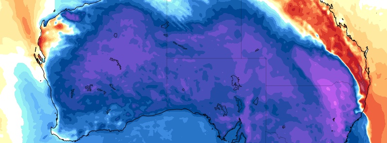
Image credit: GFS, TropicalTidbits
A deep, polar low is forecast to sweep across parts of southeastern Australia over the next couple of days, bringing cold, wet, and windy conditions. Heavy rains are expected in some areas, while Melbourne could experience its coldest April day in 60 years.
A cold front is forming in the southern Indian Ocean, driven by a deep, polar low. It is set to bring cold, wet, and windy conditions– some of the most significant as Australia heads towards winter. The front will begin in Western Australia, but Perth will remain sunny through most of this week.
"Everything changes from Wednesday," Keris Arndt from the Bureau of Meteorology (BOM) said.
"In Victoria, we’ll see rain developing overnight on Tuesday and then spreading eastwards reaching Melbourne early afternoon on Wednesday, which will likely bring some thunderstorms before some really cold air moves over."
Tuesday expect showers in the west of #SouthAustralia tracking east ahead of a cold front. Wednesday more wet conditions with front & much cooler temps with potential for isolated thunderstorms and small hail in parts of agricultural areas. For forecasts https://t.co/c1xQ3o4lOJ pic.twitter.com/c8OM3Ah9Qi
— Bureau of Meteorology, South Australia (@BOM_SA) April 27, 2020
The cold front expected to cross SE Australia this week should be preceded by a useful rain band (further to weekend rain over VIC). Conducive ocean temperatures are providing more atmospheric moisture for fronts to tap into than was seen in 2019. https://t.co/aR3QPOTGJ8 pic.twitter.com/Zjapsnhvi7
— Andrew Miskelly (@andrewmiskelly) April 26, 2020
Up to 30 cm (12 inches) of snow is expected through the alpine regions of Canberra, Victoria, New South Wales, and Tasmania on April 30.
"As we head into Wednesday, we’ll start to see some significant prefrontal rain in areas where it’s desperately needed across the northern country of Victoria to the state’s northeast and then west of the divide in NSW," said Sky News meteorologist Alison Osborne,
Aside from rains and snow, hail is also in store for southeastern states, including Victoria, Wednesday onwards.
WEDNESDAY
– Extensive showers, tending to rain in the east
– Heavy falls and localised flooding possible in the NE
– Isolated storms possible across central/eastern parts during the day
– Isolated storms and small hail possible in SW late in the day (2/6) pic.twitter.com/Is1Dp7vjrD— Bureau of Meteorology, Victoria (@BOM_Vic) April 27, 2020
THURSDAY:
– Cold, with max temps forecast to be 8-10 degrees below average
– Snow level dropping to 1200m during the day, snow on the NE ranges
– Fresh/strong SW'ly winds
– Showers across #Victoria, mostly in the S and E
– Isol storms and small hail in S and E
– Large waves (3/6) pic.twitter.com/t54gGyHHkq— Bureau of Meteorology, Victoria (@BOM_Vic) April 27, 2020
FRIDAY:
– Very cold, with snow showers continuing above 900m
– Fresh SW'ly winds
– Showers and small hail continuing, mostly in S and E (4/6) pic.twitter.com/WskStaTnRB— Bureau of Meteorology, Victoria (@BOM_Vic) April 27, 2020
Southern NSW and the ACT will be very wet on Wednesday and Thursday, with about 50 mm (1.9 inches) of rain expected in Canberra. It will be cold in the capital with a temperature of 17 °C (62.6 °F) on Wednesday pummeling to 9 °C (48.2 °F) on Friday and a piercing low of 3 °C (37.4 °F) as the region moves into very windy and cold Thursday.
Temperatures in Sydney will drop to 18 °C (64.4 °F) on Friday, with lows about 10 °C (50 °F) later in the week. Rains and some sustained and heavy showers are also possible.
Melbourne is expecting its coldest April day since 1960 if it falls below 13.2 °C (55.8 °F) on Thursday, as per forecast.
Cold temperatures will also be felt in the southern capital cities. Moving onto Friday, it will be very cold across most capitals.
Earth behavior is normal over time. An obliquiti cycle ago we had the Laschamp event with the extinction of life that couldn’t adapt. The Neanderthal DNA with differences from our ancestors could not and disappeared from this globe. Follow the path over the Earth’s crust that the magnetic poles follow. Since the magnetic north pole passes over the LOMONOSOV ridge, I expect, as with the ALPHA ridge, that the average annual temperature will drop not only in Belgium but also in Australia. Climate change is a normal terrestrial phenomenon driven by geodynamics and the sun, but abused by IPCC lobby groups to push through their green politics
We live on a planet. An electrical sentient entity. But for the interference of humans, with their planes, ships and microwave technologies, there will be consequences for this “climate forcing”, and attempted manipulation of the weather. even selling it to the highest payer. I am quite able to accept that this Earth will behave as a planet will, cyclically, and naturally. Australia is complicit in the outcomes of their part in the global deliberate polluting, and energizing, or “microwaving” the stratosphere to exact a response. It is sickening to see the chemicals mixing above my head, and to then breathe the same mix , Always “scientists” no names, and wretched humans flying the mixing planes, and piloting ships in task force style to induce controlled weather, be it denial of rain, hazing of the sky , or the drawing in of excessive moisture, to the point of flooding. This has to stop. Then we will get decent climate change as the Earth returns to normal. Air clean, water clean, crops once again nutritious. The way it should be.