Extremely Severe Tropical Cyclone “Fani” to make landfall in Odisha on May 3, India
Tropical Cyclone "Fani" has strengthened into Extremely Severe Cyclonic Storm (ESCS). It is expected to remain at this strength, or possibly as Very Severe Cyclonic Storm, as it makes landfall on Odisha coast around Puri, between Gopalpur and Chandbali sometime between 09:00 and 12:00 UTC on May 3, 2019 (14:30 – 17:30 IST May 3). Fani will bring heavy rain, very strong winds and a huge storm surge.
This storm can have a high humanitarian impact. More than 100 million people are in the path of this extremely dangerous tropical cyclone.
Cyclones in this region rarely receive sufficient western media attention, but the North Indian Ocean produced world's deadliest cyclone and one of the deadliest natural disasters in known history.
Fani is the strongest cyclone this early in a calendar year in the North Indian Ocean since Cyclone "Nargis" in 2008.
As of 17:30 UTC (23:00 IST) on May 1, Fani's center is located about 550 km (342 miles) SSW of Puri, Odisha, 300 km (186 miles) SSE of Vishakhapatnam, Andhra Pradesh and 740 km (460 miles) SSW of Digha, West Bengal.
At the time, Fani had maximum sustained winds of 185 km/h (115 mph) with gusts to 205 km/h (125 mph) and estimated central pressure of 958 hPa.
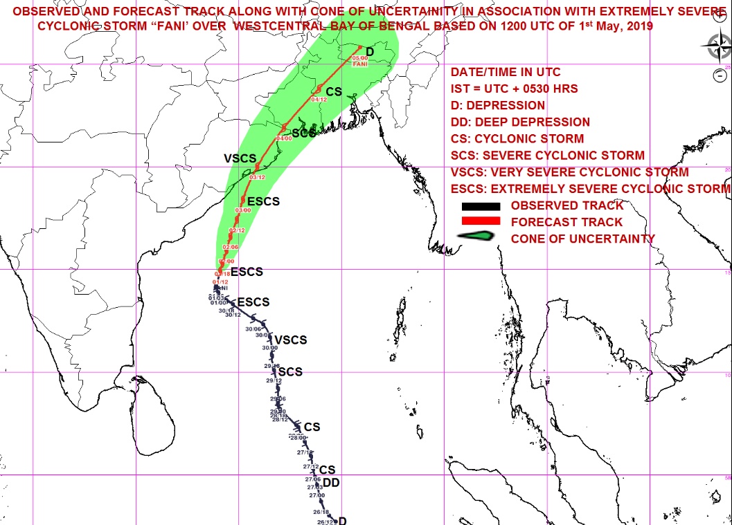
RCMS New Delhi, authority for this region, expects Fani to continue moving NNE and cross Odisha coast between Gopalpur and Chandbali, around Puri between 09:00 and 12:00 UTC on May 3, 2019 (14:30 – 17:30 IST May 3) with maximum sustained wind speed between 160 – 180 km/h (100 – 112 mph) and gusts to 200 km/h (124 mph) – Category 3 hurricane equivalent.
The Odisha government closed all educational institutions on Thursday and Friday, April 2 and 3, canceled the leaves of doctors, health officials and energy department officials.
Operations at Paradip Port in Odisha are suspended.
Over 800 000 residents have been or are in the process of being evacuated, with nearly 100 000 alone from the city of Puri.
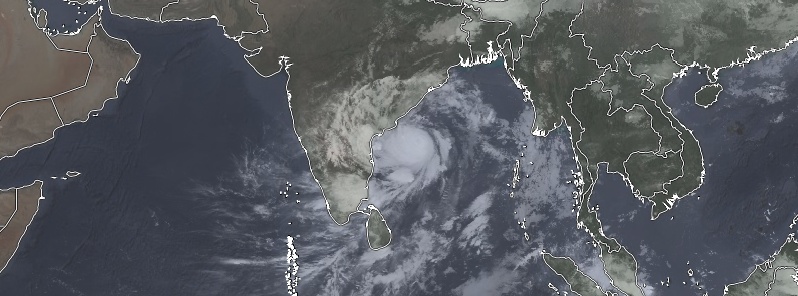
Extremely Severe Cyclonic Storm "Fani" at 19:00 UTC on May 1, 2019. Credit: UW-CIMSS, TW

Extremely Severe Cyclonic Storm "Fani" at 19:00 UTC on May 1, 2019. Credit: UW-CIMSS, TW
Warnings in place
Heavy rainfall warning
North Andhra Pradesh: Light to moderate rainfall at most places with heavy to very heavy rainfall at a few places and extremely heavy falls (>20 cm / 7.9 inches) at isolated places very likely over north coastal Andhra Pradesh (Srikakulam, Visakhapatnam and Vijayanagaram Districts) on May 2 and with heavy to very heavy rainfall at isolated places on May 3.
Odisha: Light to moderate rainfall at most places with heavy to very heavy rainfall at isolated places very likely over south coastal Odisha on May 2. It is likely to increase with moderate rainfall at most places and heavy to very heavy rainfall at a few places and extremely heavy falls (>20 cm / 7.9 inches) at isolated places over coastal Odisha and adjoining districts of interior Odisha on May 3. Light to moderate rainfall at most places with heavy to very heavy falls at isolated places over north Odisha on May 4.
West Bengal: Light to moderate rainfall at most places with heavy falls at isolated places very likely over coastal and adjoining districts of West Bengal on May 3 and with heavy to very heavy rainfall at a few places and extremely heavy falls at isolated places over Gangetic West Bengal on May 4. Light to moderate rainfall at most places with heavy falls at isolated places over Sub-Himalayan West Bengal and Sikkim on May 4.
Arunachal Pradesh and Assam and Meghalaya: Light to moderate rainfall at most places with isolated heavy to very rainfall very likely over Arunachal Pradesh and Assam and Meghalaya on May 4 and 5.
Wind warning
Gale wind speed reaching 180 – 190 km/h (112 – 118 mph) gusting to 210 km/h (130 mph) is very likely to prevail over west central Bay of Bengal around system center during next 24 hours and decrease thereafter.
Squally wind speed reaching 40 – 50 km/h (25 – 31 mph) gusting to 60 km/h (37 mph) is very likely to commence along and off north Andhra Pradesh and Odisha Coasts from the morning of May 2 and become gale wind speed reaching 60 – 70 km/h (up to 44 mph) gusting to 85 km/h (53 mph) from May 2 night. It is very likely to become 170 – 180 km/h (105 – 112 mph) gusting to 200 km/h (124 mph) along and off south Odisha and adjoining north Andhra Pradesh (Srikakulam District) coasts; and 90 – 100 km/h (56 – 62 mph) gusting to 115 km/h (72 mph) along and off remaining districts of coastal Odisha and north Andhra Pradesh (Visakhapatnam and Vijayanagaram Districts) by the noon on May 3 noon for subsequent 12 hours and decrease thereafter.
Squally wind speed reaching 40 – 50 km/h (25 – 31 mph) gusting to 60 km/h (37 mph) is very likely along and off West Bengal coast on May 2. It would become gale wind speed reaching 60 – 70 km/h (up to 44 mph) gusting to 85 km/h (53 mph) from May 3 evening and become 90 – 100 km/h (56 – 62 mph) gusting to 115 km/h (71 mph) from May 4 early morning for subsequent 12 hours and decrease thereafter.
Sea condition
The sea condition is phenomenal over the west-central Bay of Bengal, off north Andhra Pradesh Coasts until May 3 and over Northwest Bay of Bengal off Odisha and West Bengal during May 2 – 4.
Sea conditions very likely to be very rough to high off north Tamilnadu, Puducherry, along and off south Andhra Pradesh Coasts until May 3.
Storm surge warning
Storm surge of about 1.5 m (4.9 feet) height above astronomical tide is very likely to inundate low lying areas of Ganjam, Khurda, Puri and Jagatsinghpur Districts of Odisha at the time of landfall.
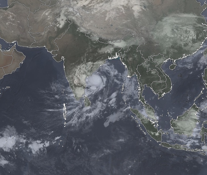
Extremely Severe Cyclonic Storm "Fani" on May 1, 2019. Credit: NASA Terra/MODIS
GFS forecast models
Featured image: Extremely Severe Cyclonic Storm "Fani" at 19:00 UTC on May 1, 2019. Credit: UW-CIMSS, TW
Commenting rules and guidelines
We value the thoughts and opinions of our readers and welcome healthy discussions on our website. In order to maintain a respectful and positive community, we ask that all commenters follow these rules.