
Rapidly intensifying and large scale storm expected to develop across the Central U.S.
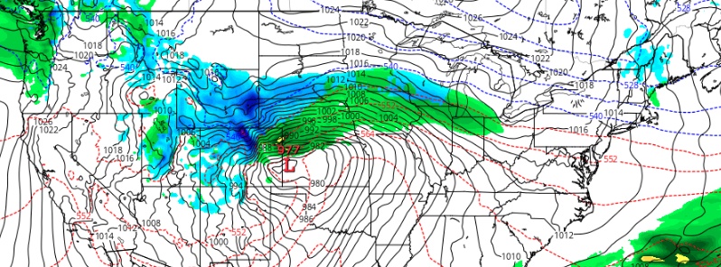
Featured image: Winter storm "Wesley" April 11 GFS model. Credit: TropicalTidbits, GFS
A rapidly intensifying and large scale storm is expected to develop across the Central U.S. by midweek featuring heavy snow, some icing, strong winds, locally heavy rainfall and severe thunderstorms. The Weather Channel named this storm Wesley. Winter storm watches have been posted from central Montana to southwest Minnesota and more are expected.
A rapidly intensifying major winter storm is expected to bring heavy snows through the Northern Rockies, heavy snows and blizzard conditions to portions of the Northern/Central Plains into the Upper Mississippi Valley Tuesday, April 9 through Thursday, April 11, 2019, NWS forecaster Oravec noted 19:29 UTC (15:29 EDT) April 8.
200 million people lie in the path of this storm, AccuWeather meteorologist Renee Duff said. "Temperatures can plummet upwards of 30 °F [17 °C] from Tuesday to Wednesday across the northern Plains, forcing residents to trade in short sleeves and sunglasses for winter gear and snow shovels in a hurry."
Heavy precipitation, that has been focused into portions of the Pacific Northwest over the past few days will be pushing inland into the Northern Great Basin/Northern Rockies tonight.
Increasing areal coverage and intensity of snow is likely through the Northern Rockies Tuesday, spreading into portions of the Northern to Central Plains into the Upper Mississippi Tuesday night into Wednesday, continuing into Thursday across portions of the Central to Northern Plains into the Upper Mississippi Valley.
Widespread heavy are snows likely from this storm over the next few days, with amounts in excess of a foot likely through the Northern Rockies and across portions of the Northern to Central Plains and Upper Mississippi Valley.
This storm is expected to intensify rapidly late Tuesday into Wednesday. This will produce increasing winds across large regions from the Southwest, Great Basin and across much of the middle section of the nation from the Southern Plains to the Northern Plains.
These potentially high winds will produce life-threatening travel conditions with blizzard conditions possible over portions of the Central/Northern Plains into the Upper Mississippi Valley late Tuesday into Thursday.
To the south of the region of heavy snows, damaging winds likely from the Southwest, across portions of the Great Basin on Tuesday and into the Southern and Central Plains during Wednesday.
Sustained winds of 48 – 80 km/h (30 to 50 mph), with gusts over hurricane force possible across these regions.
The setup for this storm is a classic mix of April ingredients, TWC's Jonathan Erdman said. "A powerhouse jet stream is expected to punch out of the West, triggering the development of strong surface low pressure over the Plains by Wednesday. Sufficient cold air will be in place to the north of that low for a swath of snow in parts of the Plains and Midwest.
This setup may sound familiar, as it has some rough similarities to last month's Plain's bomb cyclone, Erdman said.
I'm a dedicated researcher, journalist, and editor at The Watchers. With over 20 years of experience in the media industry, I specialize in hard science news, focusing on extreme weather, seismic and volcanic activity, space weather, and astronomy, including near-Earth objects and planetary defense strategies. You can reach me at teo /at/ watchers.news.
Thanks for the update on Storm Whoopass, er, Wesley. Unusual weather courtesy of deepening Eddy Grand Solar Minimum. Ask Al Gore for a refund!