
Very cold Arctic air reaches as far south as southern Texas and central Florida
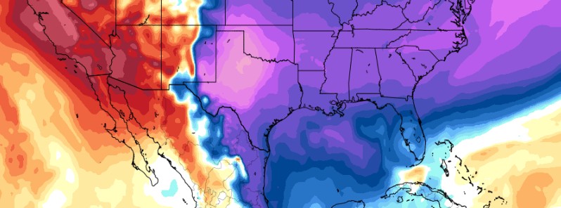
Featured image: 850 hPa temperature anomaly GFS model January 3, 2018. Credit: TropicalTidbits
After breaking numerous record, very cold Arctic cold air reached all the way to southern Texas and central Florida on Monday, January 1, 2018. Freeze warnings are in place from Texas to the Atlantic Coast and up to the Northeastern US as another cold wave is expected by the end of the week.
On Monday, January 1, temperatures across the US east of the Rocky Mountains were 11 to 17 °C (20 to 30 °F) below average. From the Southern Plains to the Ohio Valley, temperatures of 8 – 14 °C (15 to 25 °F) below average are expected 'with very high probability of record lows' on Tuesday, January 2.
There is a threat of rain/freezing rain along the Southeast Coast, heavy snow along the southern coast of Lake Superior and possible snow over parts of the Southern Mid-Atlantic Coast.
Wow, you don't see temps below zero this far south very often. #frigid #ArcticBlast pic.twitter.com/aB2SF88RMW
— Tom Niziol (@TomNiziol) January 1, 2018
As-live from potent lake effect #snow band in Oswego, NY coverage for @accuweather #ArcticBlast #snowchasing pic.twitter.com/2FVoaWHyy0
— Reed Timmer (@ReedTimmerAccu) January 1, 2018
The air at 3,300' above our heads today was in the Arctic back on Wednesday. #ArcticBlast #cltwx pic.twitter.com/s5FwvpFQWI
— Brad Panovich (@wxbrad) January 2, 2018
Cold high pressure over the Middle Mississippi/Ohio Valleys will slowly continue to modify through Thursday, January 4. In addition, upper-level energy over Eastern Ontario will aid in producing lake-effect snow downwind from the Lower Great Lakes through Wednesday morning.
Additionally, easterly flow off the Atlantic will aid in producing light rain showers over the east coast of Florida, NWS forecaster Ziegenfelder noted.
Meanwhile, another area of upper-level energy over Southern Manitoba will move southeastward aiding in the development of an upper-level trough over the Great Lakes/Ohio Valley on Wednesday into Thursday. The associated front will move into the Upper Midwest on Tuesday advancing south and eastward to the Southern Plains/Lower Mississippi Valley into the Ohio Valley/Lower Great Lakes by Wednesday evening.
The system will develop snow over parts of the Upper Mississippi Valley/Upper Great Lakes on Tuesday afternoon into Tuesday evening that will move into the Great Lakes overnight Tuesday continuing into Wednesday evening.
A third area of upper-level energy over the Central High Plains will move southeastward to the Southeast Coast by Wednesday evening developing an area of low pressure off the East-Central Coast of Florida on Wednesday afternoon.
The area of low pressure will begin to quickly deepen overnight Wednesday while moving northeastward to off the Southern Mid-Atlantic Coast. Circulation around the low will aid in streaming moisture into the Southeast by Wednesday afternoon and into the Mid-Atlantic Coast by overnight Wednesday.
There is a slight risk of rain/freezing rain developing over parts of the Southeast Coast on Wednesday afternoon into evening. Wednesday evening into Thursday, snow will develop over parts of the Southern and Northern Mid-Atlantic Coast. Also, rain will end over Florida by Wednesday evening.
Elsewhere, an upper-level low that is southeastward off the California Coast over the Pacific will move northeastward and weaken to Northern California by overnight Wednesday. Moisture associated with the low will move onshore over California by Wednesday afternoon into Thursday. The system will produce light rain over parts of Northern/Central California on Wednesday afternoon into Thursday, too.
Several blasts of very cold Arctic air affecting North America for over a week now are blamed for the deaths of at least 7 people in the United States. A list of broken records is here.
I'm a dedicated researcher, journalist, and editor at The Watchers. With over 20 years of experience in the media industry, I specialize in hard science news, focusing on extreme weather, seismic and volcanic activity, space weather, and astronomy, including near-Earth objects and planetary defense strategies. You can reach me at teo /at/ watchers.news.
Commenting rules and guidelines
We value the thoughts and opinions of our readers and welcome healthy discussions on our website. In order to maintain a respectful and positive community, we ask that all commenters follow these rules.