
Very M6.9 earthquake hits Java, Indonesia – 4 dead, 36 injured, 3 290 homes damaged
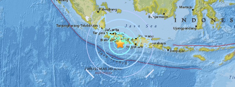
Image credit: USGS
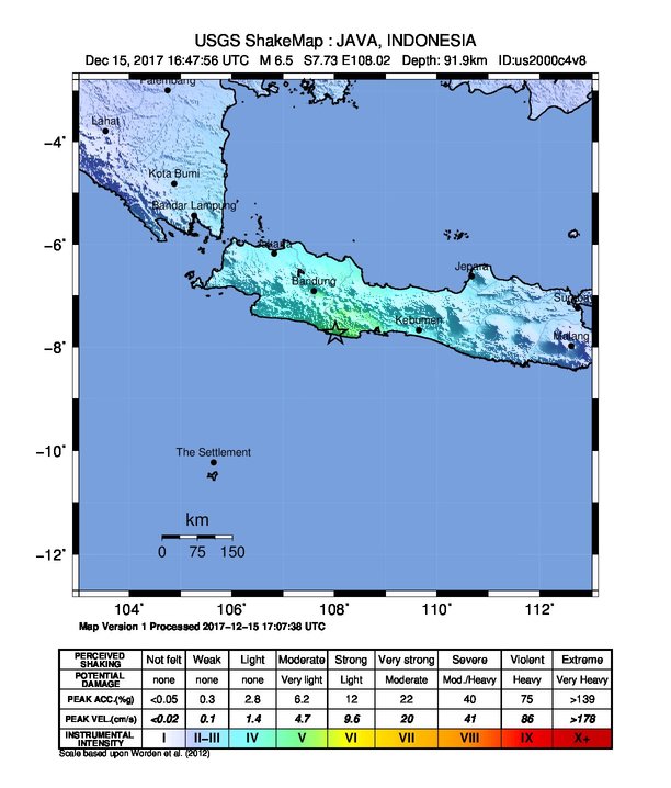
A very strong earthquake registered by the BMKG as M6.9 hit the coast of West Java province, Indonesia at 16:47 UTC (23:47 local time) on December 15, 2017. The agency is reporting a depth of 107 km (66 miles). The USGS initially reported M7.3 and downgraded to M6.5 at a depth 91.9 km (57 miles). EMSC is reporting M6.5 at a depth of 112 km (70 miles). Australia Geoscience is reporting M6.7 at a depth of 93 km (57.8 miles).
According to the USGS, the epicenter was located 0.3 km (0.3 miles) ESE of Cipatujah (population 0), 43.4 km (27 miles) SSW of Singaparna (population 48 882), 44 km (27.4 miles) SSW of Kawalu (population 50 541), 50 km (31.1 miles) SSW of Tasikmalaya (population 271 143), and 102.1 km (63.5 miles) SSE of Bandung (population 1 699 719), Indonesia.
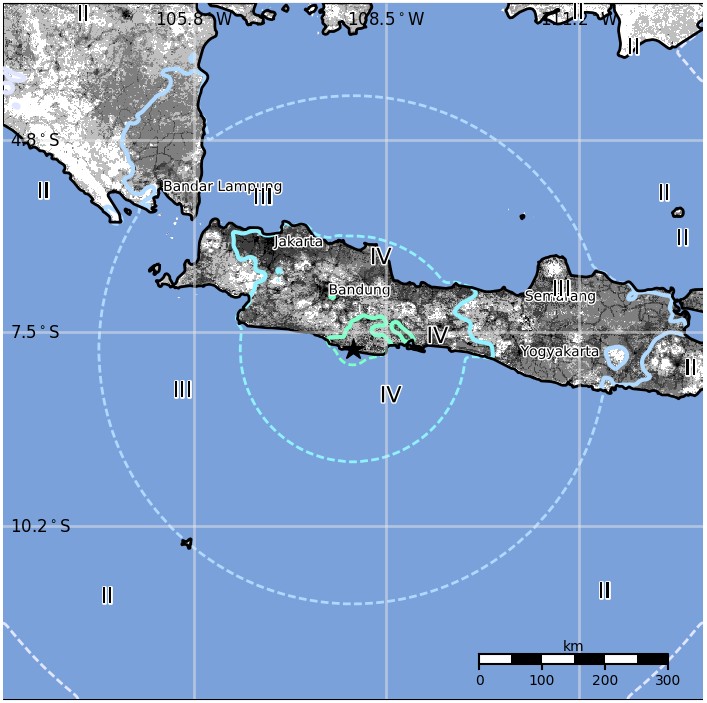
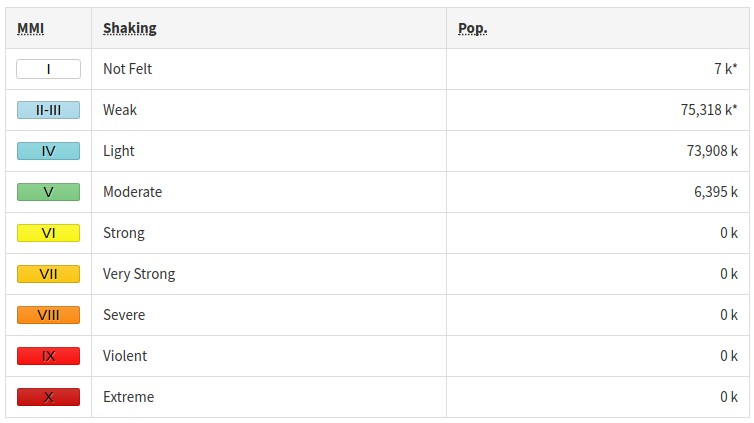
There are 13 020 000 living within 100 km (6.2 miles).
6 395 000 people are estimated to have felt moderate shaking, 73 908 000 light and 75 318 000 weak.
The quake was felt for about 20 seconds in the capital of Jakarta.
 The USGS issued a green alert for shaking-related fatalities and economic losses. There is a low likelihood of casualties and damage.
Overall, the population in this region resides in structures that are vulnerable to earthquake shaking, though resistant structures exist. The predominant vulnerable building types are unreinforced brick with concrete floor and precast concrete frame with wall construction.
Update
Authorities issued a tsunami warning for parts of Java's coastline, saying there is a potential for waves between 0.3 and 0.5 m (1 – 1.6 feet). The warning ended 02:30 local time, December 16 (19:39 UTC, December 13).
There are reports of people running out of buildings and heavy traffic on roads as people left coastal areas.
According to Sutopo Purwo Nugroho, a National Disaster Mitigation Agency spokesman, a 62-year-old man was killed in Ciamis region and there are reports of more deaths and injuries in the same region.
Houses and buildings are damaged in many areas, he said.
Plafon Pendopo Kabupaten Cilacap ambrol akibat gempa 6,9 SR. pic.twitter.com/sfMA3vpkrx
— Sutopo Purwo Nugroho (@Sutopo_BNPB) December 15, 2017
Kerusakan bangunan di RSUD Banyumas. Tembok dan plafon rusak. Lebih dari 50 pasien dievakuasi keluar banguna pascagempa 6,9 SR. pic.twitter.com/RPJlwZbW51
— Sutopo Purwo Nugroho (@Sutopo_BNPB) December 15, 2017
Kerusakan bangunan di RSUD Banyumas. Tembok dan plafon rusak. Lebih dari 50 pasien dievakuasi keluar banguna pascagempa 6,9 SR. pic.twitter.com/RPJlwZbW51
— Sutopo Purwo Nugroho (@Sutopo_BNPB) December 15, 2017
Beberapa rumah di Kabupaten Ciamis rusak akibat gempa. Terdapat korban jiwa dan luka. Masyarakat di pesisir mengungsi ke tempat yang lebih tinggi yang aman dari tsunami. pic.twitter.com/gBvwejKlv7
— Sutopo Purwo Nugroho (@Sutopo_BNPB) December 15, 2017
December 19
The quake is now blamed for the deaths of 4 people. 36 have been injured and 3 290 homes damaged.
Estimated population to earthquake shaking
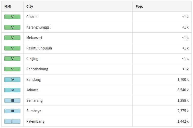
Selected cities exposed
Regional seismicity
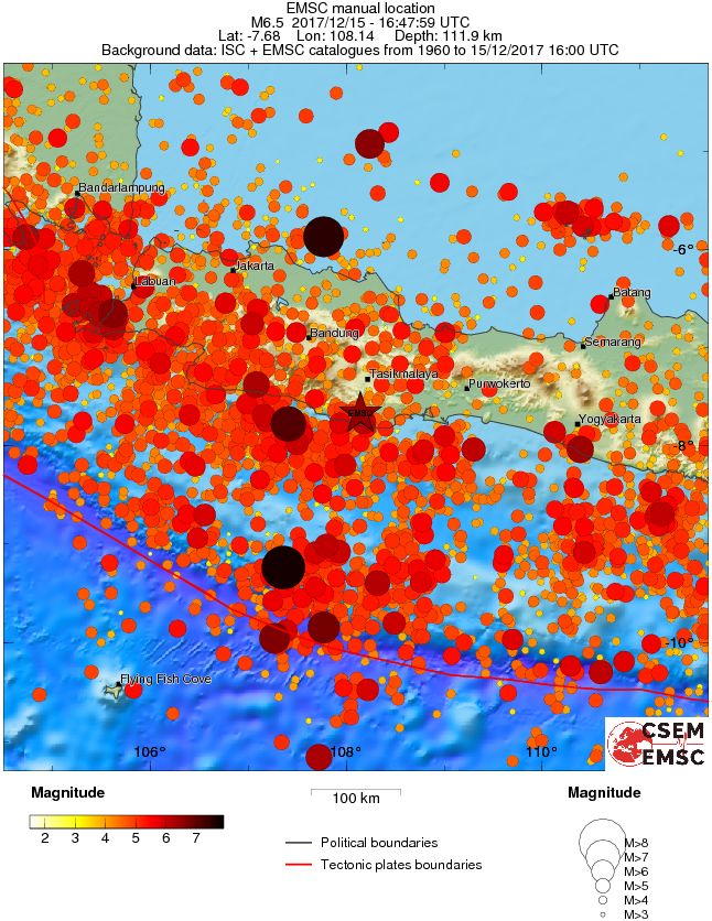
Seismotectonics of the Java region
The Sunda convergent margin extends for 5,600 km from the Bay of Bengal and the Andaman Sea, both located northwest of the map area, towards Sumba Island in the southeast, and then continues eastward as the Banda arc system. This tectonically active margin is a result of the India and Australia plates converging with and subducting beneath the Sunda plate at a rate of approximately 50 to 70 mm/yr. The main physiographic feature associated with this convergent margin is the Sunda-Java Trench, which stretches for 3,000 km parallel to the Java and Sumatra land masses and terminates at 120° E. The convergence of the Indo-Australia and Sunda plates produces two active volcanic arcs: Sunda, which extends from 105 to 122° E and Banda, which extends from 122 to 128° E. The Sunda arc results solely from relatively simple oceanic plate subduction, while the Banda arc represents the transition from oceanic subduction to continental collision, where a complex, broad deforming zone is found.
Based on modern activity, the Banda arc can be divided into three distinct zones: an inactive section, the Wetar Zone – bound by two active segments, the Flores Zone in the west and the Damar Zone in the east. The lack of volcanism in the Wetar Zone is attributed to the collision of Australia with the Sunda plate. The gap in volcanic activity is underlain by a gap in intermediate depth seismicity, which is in contrast to nearly continuous deep seismicity below all three sections of the arc. The Flores Zone is characterized by down-dip compression in the subducted slab at intermediate depths and late Quaternary uplift of the forearc. These unusual features, along with GPS data interpretations, show that the Flores Zone marks the transition between subduction of oceanic crust in the west and the collision of continental crust in the east.
The Java section of the Sunda arc is considered relatively aseismic historically when compared to the highly seismically active Sumatra section, despite both areas being located along the same active subduction margin. Shallow (0-20 km) events have occurred historically in the overlying Sunda plate, causing damage to local and regional communities. A recent example was the May 26, 2006 M6.3 left-lateral strike-slip event, which occurred at a depth of 10 km in central Java, and caused over 5,700 fatalities. Intermediate depth (70-300 km) earthquakes frequently occur beneath Java as a result of intraplate faulting within the Australia slab. Deep (300-650 km) earthquakes occur beneath the Java Sea and the back-arc region to the north of Java. Similar to other intermediate depth events these earthquakes are also associated with intraslab faulting. However, this subduction zone exhibits a gap in seismicity from 250-400 km, interpreted as the transition between extensional and compressional slab stresses. Historic examples of large intraplate events include: the 1903 M8.1 event, 1921 M7.5 event, 1977 M8.3 event, and August 2007 M7.5 event.
Large thrust earthquakes close to the Java trench are typically interplate faulting events along the slab interface between the Australia and Sunda plates. These earthquakes also generally have high tsunamigenic potential due to their shallow hypocentral depths. In some cases, these events have demonstrated slow moment-release, and have been defined as ‘tsunami’ earthquakes, where rupture is large in the weak crustal layers very close to the seafloor. These events are categorized by tsunamis that are significantly larger than predicted by the earthquake’s magnitude. The most notable tsunami earthquakes in the Java region occurred on June 2, 1994 (M7.8) and July 17, 2006 (M7.7). The 1994 event produced a tsunami with wave run-up heights of 13 m, killing over 200 people. The 2006 event produced a tsunami of up to 15 m, and killed 730 people. While both of these tsunami earthquakes were characterized by rupture along thrust faults, they were followed by an abundance of normal faulting aftershocks. These aftershocks are interpreted to result from extension within the subducting Australia plate, while the mainshocks represented interplate faulting between the Australia and Sunda plates. (USGS)
I'm a dedicated researcher, journalist, and editor at The Watchers. With over 20 years of experience in the media industry, I specialize in hard science news, focusing on extreme weather, seismic and volcanic activity, space weather, and astronomy, including near-Earth objects and planetary defense strategies. You can reach me at teo /at/ watchers.news.
Commenting rules and guidelines
We value the thoughts and opinions of our readers and welcome healthy discussions on our website. In order to maintain a respectful and positive community, we ask that all commenters follow these rules.