
43 000 homes without power as Bay Area sets record highs, California

Image credit: NWS Bay Area
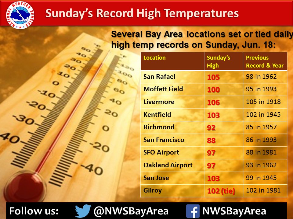
According to data provided by the National Weather Service, nine cities in San Francisco Bay Area have set daily high temperature records on Sunday, June 18, 2017. Although temperatures remained high through Monday and meteorologists said more records might be broken by the end of the week, Sunday was the best day for that.
The hottest city yesterday was Livermore in Alameda County with 106 °F (41.1 °C). This broke its previous record of 105 °F (40.5 °C) set in 1918.
San Rafael in Marin County was the second hottest city in the region. The temperature there reached 105 °F (40.5 °C), breaking the record of 98 °F (36.7 °C) set in 1962.
Moffett Field registered 100 °F (37.8 °C), which broke the record of 95 °F (35 °C) set in 1993.
Kentfield recorded 103 °F (39.4 °C), breaking the previous record of 102 °F (38.9 °C) set in 1945.
The temperature in Richmond rose to 92 °F (33.3 °C), breaking the old record of 85 °F (29.4 °C) in 1957.
In San Francisco, the temperature reached 88 °F (31.1 °C), which broke the record of 86 °F (30 °C) set in 1993.
At San Francisco International Airport the temperature reached 97 °F (36.1 °C), breaking the previous record of 88 °F (31.1 °C) set in 1981.
At Oakland International Airport, the temperature also reached 97 °F (36.1 °C), breaking the record of 93 °F (33.9 °C) set in 1962.
In San Jose, the temperature reached 103 °F (39.4 °C), breaking the old record of 99 °F (37.2 °C) in 1945.
According to Pacific Gas & Electric Company, thousands of Bay Area residents lost power during the day due heat gripping the region. At one point, more than 43 000 customers were effected by the outages. By around 23:00, the number of affected households had been reduced by half.
The hardest hit areas included East San Jose and a number of cities in the East Bay including Pleasanton, Fremont, Antioch and Livermore.
Isolated showers developed in the East Bay around midnight Sunday Night, moving to the NNW. Expected to end by daybreak Monday. #cawx pic.twitter.com/BLoYcLVVlP
— NWS Bay Area (@NWSBayArea) June 19, 2017
Wondering why the isolated #bayarea thunderstorm ⛈ tonight? It's impressive blowoff from Sierra thunderstorms making it all the way here: pic.twitter.com/VV6njG9p2E
— Jeff Ranieri (@JeffRanieri) June 19, 2017
GOES 16 visible satellite imagery showing today's thunderstorms over the Sierra#CAwx pic.twitter.com/6te4JNNCff
— NWS Bay Area (@NWSBayArea) June 19, 2017
By the end of the day, isolated thunderstorms formed around the Bay Area, bringing a little bit of moisture and instability that moved in from the south to the southeast.
NWS Meteorologist Charles Bells says the first storm cell hit Alameda County, south of Pleasanton, a little after 23:00 local time, and moved near Castro Valley before dissipating. A stronger cell formed in southern Alameda County in unincorporated territory and swooped into Pleasanton around midnight. That storm continued onto Castro Valley around 00:30 and then Berkeley at 01:00 and headed up to San Rafael at 01:30. The cell eventually moved west of Petaluma and then fell apart.
"Now we have more stable air," Bell says. "We're not expecting any showers the rest of the week."
Bells says thunderstorms of this nature aren't common in California in the late spring, but can occur several times a year.
"Heat helps produce more energy," he said. "In Las Vegas, you have the classic example where you can have temps in the high-90s and low-100s and during the monsoon season and thunderstorms come through and you can get flash-flooding."
I'm a dedicated researcher, journalist, and editor at The Watchers. With over 20 years of experience in the media industry, I specialize in hard science news, focusing on extreme weather, seismic and volcanic activity, space weather, and astronomy, including near-Earth objects and planetary defense strategies. You can reach me at teo /at/ watchers.news.
Commenting rules and guidelines
We value the thoughts and opinions of our readers and welcome healthy discussions on our website. In order to maintain a respectful and positive community, we ask that all commenters follow these rules.