
Tropical Storm “Beatriz” to make landfall over Oaxaca, Mexico

Featured image: Tropical Storm "Beatriz" at 17:30 UTC. Credit: NOAA/GOES, CONAGUA
Tropical Depression 02E located just off the western coast of Mexico has further strengthened today and was named Beatriz at 18:00 UTC. Landfall over Oaxaca, Mexico is expected later today or tomorrow, June 2, 2017. This storm is a heavy rain producer so the main hazards are flash floods and mudslides. Beatriz is the second named storm of the 2017 Pacific Hurricane Season.
At 18:00 UTC on June 1, 2017 (13:00 CDT), the center of Tropical Storm "Beatriz" was located about 60 km (40 miles) WSW of Puerto Angel and 335 km (220 miles) of Acapulco, Mexico.
The storm is moving to the NNE near 9 km/h (6 mph) and this motion is expected to continue through Friday, June 2. On this forecast track, NHC warns, the center of tropical cyclone Beatriz is expected to move inland across the state of Oaxaca later today or tonight (CDT time).
La #DepresionTropical Tropical 2-E ahora como #TormentaTropicalBeatriz al sur de las costas de #Oaxaca pic.twitter.com/1UAE3uArkp
— CONAGUA Clima (@conagua_clima) June 1, 2017
Recent satellite wind data indicate that maximum sustained winds were near 70 km/h (45 mph) at 18:00 UTC. The estimated minimum central pressure is 1004 hPa.
Little change is likely before landfall. After landfall, Beatriz is expected to weaken and dissipate on Friday over the mountains of southeastern Mexico.

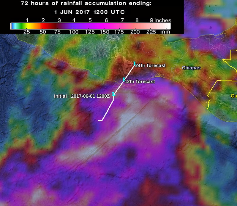
Credit: NASA/JAXA GPM
Beatriz is expected to produce total rainfall accumulations of 203 – 304 m (8 – 12 inches) across the Mexican state of Oaxaca with isolated maximum totals of 508 mm (20 inches) possible.
Lighter amounts in the 25.4 mm to 76.2 mm (1 to 3 inches) range are possible across the southern portion of the state of Veracruz.
This rainfall is likely to produce life-threatening flash floods and mudslides.

Teo Blašković founded The Watchers in 2011 and edited it until 2026, covering seismic and volcanic activity, extreme weather, space weather and near-Earth objects. Articles on this page are his archive.
Published in the last 24 hours
- Cyclone Akvan crossed the north Andhra Pradesh and south Odisha coasts close to Gopalpur on November 20 with 70-80 km/h winds gusting to 90, and has weakened into a deep depression
- High Risk of excessive rainfall covers Florida’s Space Coast as St. Johns River near Cocoa reaches 5.67 m
- Asteroid 2026 WJ to pass Earth at 1.7 lunar distances at 04:20 UTC on November 22, with 2026 WD following at 4.4 lunar distances on November 23
- A broad low over southeastern Florida and the northwestern Bahamas has a 30 percent chance of subtropical or tropical development within 48 hours and a 50 percent chance within 7 days, the National Hurricane Center says

Global Warming is Dead! Global tax to control are lives dead at Paris! Be ready for mini ice age for the next 2 decades. Food shortage, floods, earthquake, volcanic activity, Wild weather, colder winters, shorter growing seasons. More cloud cover to come due to increase in cosmic rays.