
Historic flooding hits Missouri and Arkansas, more heavy rain on the way
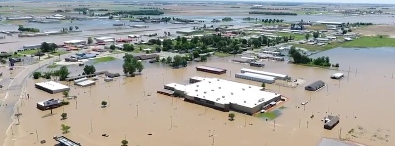
Image credit: Flooding in Pocahontas, Arkansas - May 2017.
Parts of Missouri and Arkansas are experiencing historic flooding after a powerful storm produced deadly tornadoes, strong winds and heavy rain, leaving at least 20 people dead and dozens injured. Although flooding in some areas already reached historic levels, this event is still not over as another storm is set to drop heavy rain on already soaked Missouri, Arkansas, Oklahoma, Illinois and Indiana through the rest of the week.
Hundreds of roads were closed in Missouri, Arkansas and Illinois over the weekend as dangerous weather system rolled in with strong winds and heavy rain. Some areas saw as much as 280 mm (11 inches). The rain caused a sudden rise in rivers, some of which already reached historic levels before the next round of heavy rain hits the region. The nation's biggest rivers are flooding, too.
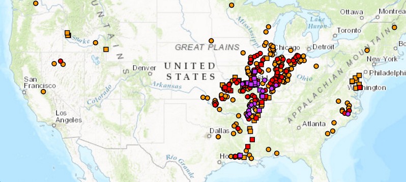
As of 21:00 UTC on May 3, 31 river gauges reported major flooding, 96 moderate, 160 minor and 233 near flood stage. Most of them in Missouri, Arkansas, and Illinois.
A mandatory evacuation order was issued Tuesday, May 2, 2017, for the east part of the town of Pocahontas (population 6 500) in Arkansas, some 201 km (125 miles) northeast of Little Rock, as the Black River rose to nearly 9 m (29 feet), a record.
"This is a historical crest. The levees weren't designed for overtopping," Randolph County Judge David Jansen said. "When they go, we're going to have a wall of water pouring out." On Wednesday, the levee on the Black River at Pocahontas failed and water gushed into the town.
Significant flooding is expected by the end of the week on the Mississippi River south of St. Louis, Missouri, including the towns of Cape Girardeau, Missouri, and Cairo, Illinois, as the massive amounts of water move downstream. Forecasters say the Mississippi River at Cape Girardeau is on track to crest at just over 15 m (48 feet) on May 6, which would be a near record.
Several points on the Missouri River in eastern Missouri are expected to rise 3 m (10 feet) above flood stage or higher by the end of the week.
St. Louis County officials say 200 homes along the Meramec have been damaged in the flooding and another 1 500 are potentially in harm's way.
Residents of West Alton (population 500), 32 km (20 miles) north of St. Louis on the Missouri River are being asked to evacuate today as authorities fear a breach of a nearby levee.
Another levee breached in Franklin County, southwest of the city, early Wednesday, but flooding mostly affected farmland, The Weather Channel reported.
The flooding has forced Missouri transportation officials to close Interstate 55, along with other major routes Wednesday, effectively cutting off St. Louis from any roads to the southeast.
According to Missouri transportation officials, I-55 closed at 12:00 local time Wednesday after rising water levels on the Meramec River inundated numerous roads. MoDot says the roads will remain closed for the remainder of the week. A 92-km (57 miles) stretch of I-44 from central to southern Missouri is also closed, along with a 37-km (23 miles) stretch in suburban St. Louis.
Along the Meramec River, in suburban St. Louis, thousands of sandbags are protecting homes and businesses in Eureka, and authorities fear a breach on a levee in nearby Valley Park where the river crested at just over 13 m (43 feet) on May 2, just shy of a record.
"After flooding smashed records that had stood for over 100 years, more heavy rain is headed toward the Ozarks and mid-Mississippi Valley, bringing a threat of renewed flash flooding and adding to already swollen rivers and reservoirs," says weather.com senior meteorologist Jon Erdman. So far, 14 flooding records have been broken and several more are expected in the coming days, Erdman said.
Forecast
A slow moving and intensifying weather system is drawing deep moisture from the Gulf of Mexico, NWS forecasters said today. Heavy rain on top of major-to-record flooding is prolonging and worsening flood conditions, and producing flash floods in some areas.
Heavy rains will move into the southeast Gulf and Ohio Valley Thursday. Severe thunderstorms along the central gulf states moves into the Southeastern US Thursday.
I'm a dedicated researcher, journalist, and editor at The Watchers. With over 20 years of experience in the media industry, I specialize in hard science news, focusing on extreme weather, seismic and volcanic activity, space weather, and astronomy, including near-Earth objects and planetary defense strategies. You can reach me at teo /at/ watchers.news.
Class can anyone say “weather wars” class. class!
Coming out of Chicago on AMTRAK on TX Eagle (Friday May 5) through Missouri to Arkansas….scheduled for departure this afternoon. Hope to make it through the extensive flooding and get home to AR! Haven’t been informed of any cancellations YET. Hoping for the best & praying for the rest…