
Catastrophic flooding unfolding as Hurricane “Sally” makes landfall near the Alabama/Florida border, U.S.
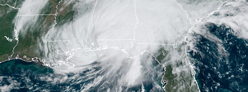
Featured image: Hurricane "Sally" at 15:10 UTC on September 16, 2020. Credit: NOAA/GOES-16, RAMMB/CIRA
Slow-moving Category 2 Hurricane "Sally" made landfall near Gulf Shores, Alabama at 10:00 UTC on September 16, 2020, with maximum sustained winds of 165 km/h (105 mph) and a minimum central pressure of 965 hPa.
- Sally is now the 8th named storm to make continental U.S. (CONUS) landfall so far in 2020. This is the most CONUS landfalling named storms on record through September 16, beating the previous record of 7 landfalls through September 16 in 1916.
- Sally is also the 4th hurricane to make landfall in CONUS so far in 2020. The most recent year with 4 CONUS hurricane landfalls by September 16 is 2004.
Catastrophic and life-threatening flooding is occurring in parts of the northern Gulf Coast and more than 500 000 customers are without power in Alabama and Florida, as of 14:20 UTC.
Sally is an extremely dangerous slow-moving hurricane, able to deliver flooding of historic proportions through the end of the week.
Life-threatening conditions and significant damage reports are coming in from Orange Beach, Alabama, just 11 km (7 miles) E of Gulf Shores, and other nearby towns.
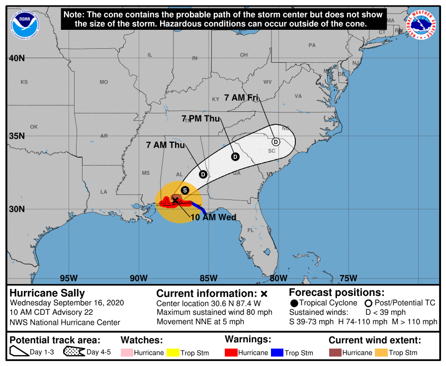
A north-northeastward to northeastward motion at a slightly faster forward speed is expected later today and tonight, followed by a faster northeastward motion on Thursday.
On the forecast track, the center of Sally will move across the extreme western Florida panhandle and southeastern Alabama through early Thursday, and move over central Georgia Thursday afternoon through Thursday night.
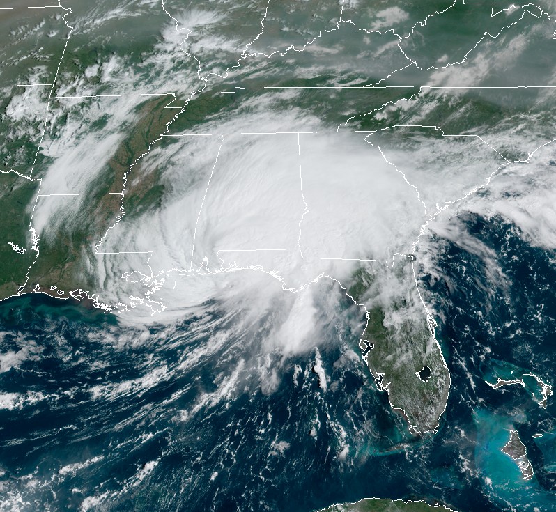
Hurricane "Sally" at 15:10 UTC on September 16, 2020. Credit: NOAA/GOES-16, RAMMB/CIRA
At 14:00 UTC (09:00 CDT), Sally's center was located about 30 km (20 miles) W of Pensacola, Florida. Its maximum sustained winds were 140 km/h (85 mph) and minimum central pressure 972 hPa. The storm was moving NNE at 7 km/h (4 mph). By 15:00 UTC, winds decreased to 130 km/h (80 mph).
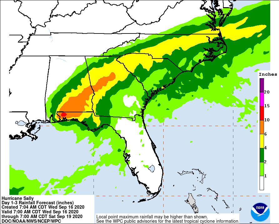
Historic and catastrophic flooding is unfolding along and just inland of the coast from west of Tallahassee, Florida, to Mobile Bay, Alabama, NHC said.
In addition, widespread moderate to major river flooding is forecast.
Significant flash and urban flooding, as well as widespread minor to moderate river flooding, is likely across inland portions Alabama into central Georgia.
Widespread flash and urban flooding is possible, as well as widespread minor to moderate river flooding, across western South Carolina into western and central North Carolina.
Scattered flash and urban flooding is possible, as well as scattered minor river flooding in southeast Virginia.
Life-threatening storm surge is occurring along portions of the coastline from Alabama to the western Florida Panhandle, including Pensacola Bay and southern portions of Mobile Bay.
Hurricane conditions are expected this morning and then continue into this afternoon within portions of the Hurricane Warning area along the Mississippi and Alabama coastlines and the western Florida Panhandle.
I'm a dedicated researcher, journalist, and editor at The Watchers. With over 20 years of experience in the media industry, I specialize in hard science news, focusing on extreme weather, seismic and volcanic activity, space weather, and astronomy, including near-Earth objects and planetary defense strategies. You can reach me at teo /at/ watchers.news.
For all the destruction and pain the American people are suffering, Congress wants to give the people a measly 1,200.00 check. Thanks for nothing Congress.