
Unexpected, powerful eruption of Bogoslof volcano, Alaska
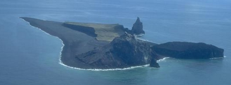
Featured image: Bogoslof Island is the summit of a largely submarine stratovolcano located in the Bering Sea 50 km behind the main Aleutian arc. Credit: Terry Keith (USGS/AVO), 1994.
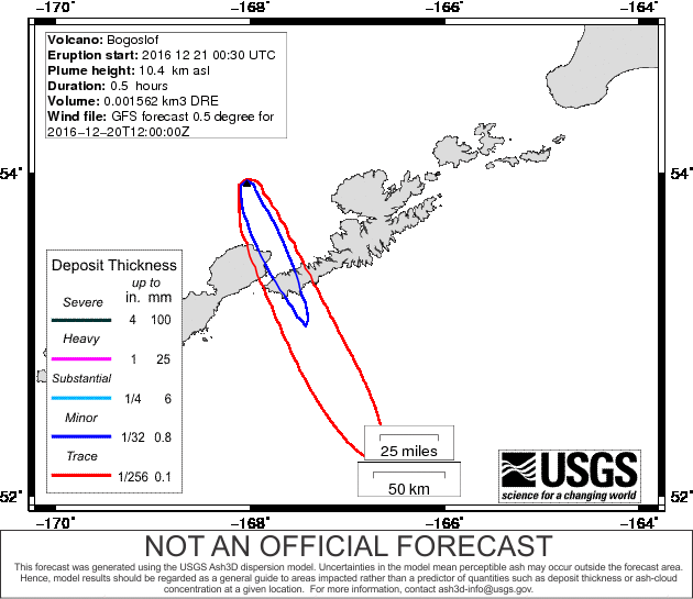
An unexpected, powerful eruption of Bogoslof volcano, Alaska occurred at about 00:35 UTC on December 21, 2016. The eruption lasted about 30 minutes and sent volcanic ash to an estimated altitude of 10.3 km (34 000 feet) above sea level. The Aviation Color Code was briefly raised to Red. The last eruption of this volcano took place in 1992.
According to Alaska Volcano Observatory (AVO), a short-lived explosive eruption was reported by several pilots.
Satellite data showed a discrete explosion that detached and drifted to the south by 01:15 UTC. The Aviation Color Code was increased to Red and the Volcano Alert Level to Warning.
A subsequent pilot report from 01:50 UTC indicated that activity had decreased and the cloud was dispersing.
The ash cloud was carried southward over the Gulf of Alaska and no ash fell on inhabited areas. No further explosions have been detected in seismic and infrasound networks indicating that the activity has subsided.
No activity is apparent in recent nighttime satellite images.
Several hours later, the Aviation Color Code was lowered to Orange and the Volcano Alert Level to Watch.
"There is no ground-based volcano monitoring equipment on Bogoslof volcano so AVO is unable to provide a forecast of future eruptive activity. We will monitor satellite images and data from distant seismic and infrasound instruments for indications of significant explosive activity," the observatory said.
Some previous eruptions of Bogoslof have lasted for weeks to months, and further explosive activity could occur with little warning, the observatory added. Mariners in the area should use caution.
@alaska_avo Index map showing location of #Bogoslof #volcano. https://t.co/bZXM3tfQmf pic.twitter.com/MYQf4orFgF
— Alaska AVO (@alaska_avo) December 21, 2016
Yep, looks like a little poof. Data from Himawari-8 via @UWSSEC in the 7.3um Band (sensitive to SO2) confirms. pic.twitter.com/VPpwrq1XRy
— James Hyde (@wxmeddler) December 21, 2016
The last eruption of this volcano took place from July 6 to 24, 1992. It had Volcanic Explosivity Index (VEI) of 3 and produced a new dome.
The first known eruption of this volcano started in May 1796 and lasted until 1804. Since then, the volcano had at least 9 (VEI 0 – 3) eruptions.
"Only about 4 300 people live within 100 kilometers (62 miles) of the volcano, but as the reports suggest, there is an awful lot of air traffic that crosses the Aleutian Islands, heading from North America to Asia. The quick notices from the Volcano Ash Advisory Centers (VAAC) about eruptions like this one from an unexpected source like Bogoslof are vital for air traffic controllers and airlines to change routes and avoid volcanic ash hazards for aircraft," volcanologist Erik Klemetti said.
Geological summary
Bogoslof is the emergent summit of a submarine volcano that lies 40 km north of the main Aleutian arc. It rises 1500 m above the Bering Sea floor. Repeated construction and destruction of lava domes at different locations during historical time has greatly modified the appearance of this "Jack-in-the-Box" volcano and has introduced a confusing nomenclature applied during frequent visits of exploring expeditions.
The present triangular-shaped, 0.75 x 2 km island consists of remnants of lava domes emplaced from 1796 to 1992. Castle Rock (Old Bogoslof) is a steep-sided pinnacle that is a remnant of a spine from the 1796 eruption. Fire Island (New Bogoslof), a small island located about 600 m NW of Bogoslof Island, is a remnant of a lava dome that was formed in 1883.
The Watchers team and our contributors bring the latest on extreme weather, earthquakes, volcanic eruptions, space weather, and all things science. We're all about making sense of the natural world and keeping you informed on what’s happening. Got a tip or a question? Hit us up using the form at newstips!
Commenting rules and guidelines
We value the thoughts and opinions of our readers and welcome healthy discussions on our website. In order to maintain a respectful and positive community, we ask that all commenters follow these rules.