
Significant explosive eruption at Bogoslof, Aviation Color Code Red
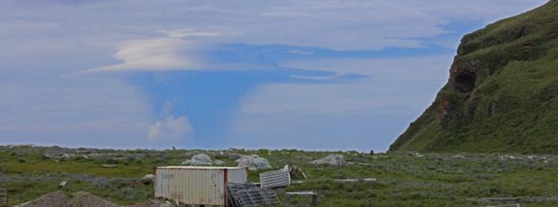
Image credit: Volcanic cloud rising above Bogoslof Volcano on June 23, 2017. View is from Mutton Cove on southwest Unalaska Island about 67 km (41 miles) southeast of the volcano. Photo by Masami Sugiyama courtesy of Allison Everett. AVO estimated the volcanic cloud reached about 11 km (36 000 feet) above sea level.
A significant explosive eruption began at Bogoslof volcano at about 18:00 UTC (10:00 AKDT) on August 7, 2017. The eruption continued through about 21:00 UTC as indicated in seismic, satellite and lightning data.
A pilot report at 18:45 UTC indicates that the ash cloud had reached 9.7 km (32 000 feet) above sea level. Thus, AVO is raising the Aviation Color Code to RED and Alert level to WARNING for Bogoslof volcano.
Winds are currently to the south. Seismic and infrasound data suggest that the ash emissions are continuing.
The eruption is longer-lived than most of the events in the eruptive sequence that started in December 2016. Satellite images show that ash from the eruption is forming a continuous cloud, still attached at the volcano, that is being carried by strong winds south over Umnak Island and then out over the Pacific.
The National Weather Service Alaska Aviation Weather Unit has issued a SIGMET warning message to aviation for the volcanic cloud up to an altitude of 10.4 km (34 000 feet) asl.
Geological summary
Bogoslof is the emergent summit of a submarine volcano that lies 40 km (24.8 miles) north of the main Aleutian arc. It rises 1 500 m (4 920 feet) above the Bering Sea floor. Repeated construction and destruction of lava domes at different locations during historical time has greatly modified the appearance of this "Jack-in-the-Box" volcano and has introduced a confusing nomenclature applied during frequent visits of exploring expeditions.
The present triangular-shaped, 0.75 x 2 km (0.46 x 1.2 miles) island consists of remnants of lava domes emplaced from 1796 to 1992. Castle Rock (Old Bogoslof) is a steep-sided pinnacle that is a remnant of a spine from the 1796 eruption. Fire Island (New Bogoslof), a small island located about 600 m (1 970 feet) NW of Bogoslof Island, is a remnant of a lava dome that was formed in 1883. (GVP)
I'm a dedicated researcher, journalist, and editor at The Watchers. With over 20 years of experience in the media industry, I specialize in hard science news, focusing on extreme weather, seismic and volcanic activity, space weather, and astronomy, including near-Earth objects and planetary defense strategies. You can reach me at teo /at/ watchers.news.
Commenting rules and guidelines
We value the thoughts and opinions of our readers and welcome healthy discussions on our website. In order to maintain a respectful and positive community, we ask that all commenters follow these rules.