
Bulusan covers nearby communities in ash, Philippines
Featured image: Satellite image of the Bulusan volcano, October 23, 2016. Image credit:
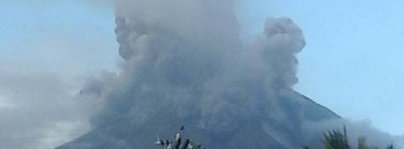
The seismic network of the Bulusan volcano, Philippines, recorded 33 volcanic earthquakes over the last 24 hours (by 00:00 UTC on October 24), preceding two phreatic eruptions. The eruptions, accompanied by rumbling sounds and sulfur smells, covered nearby communities in ash. A 4-km (2.5 miles) radius of Permanent Danger Zone and Extended Danger Zone remains in place, along with appropriate warnings for residents and aviation.
The first of the events was recorded at 07:31 UTC on October 23 while the second followed at 07:39 UTC, according to PHIVOLCS. Both eruptions lasted about 15 minutes. A noticeable increase in sulfur dioxide was measured prior to the eruptions.
The first one originated from the summit crater and it generated a 2.5 km (8 202 feet) high dirty-white to grayish column of ashes, which drifted west-southwestward. The eruption caused a small pyroclastic flow, that cascaded about 2 km (1.2 miles) down the slope the volcano summit.
Ash traces were reported in Gabao, Bulawan, Gulang-gulang, Monbon, Cogon, and Tinampo of Irosin town. A 0.5 mm (0.02 inches) thick ash layer was observed in Bolos, Irosin, and Caladgao in the Juban municipality.
The thickest ash (1 mm (0.04 inches)) was reported in Puting Sapa, Juban.
LOOK: Mt. Bulusan generated another phreatic eruption today that lasted for 15 minutes. (@helenmflores) | Photos by Jeric de la Rosa pic.twitter.com/UWLtK4Igbj
— The Philippine Star (@PhilippineStar) October 23, 2016
The second, smaller eruption, originated from the southeast vent and generated a 500 m (1 640 feet) high dirty-white to grayish ash column above the vent.
Rumbling sounds were heard in Gulang-gulang, Tinampo, Monbon, and Mapaso in Irosin town, and similar sounds accompanied by sulfur smells were reported in Aniog and Putting Sapa, Juban.
Over the last 24 hours, 33 volcanic earthquakes were reported, most of which preceded the eruptions.
On the morning of October 23 (local time), an increase in sulfur dioxide to 578 tons per day was recorded, before the eruptions. Leveling data from the period between October 17 and 23 suggested inflationary changes of the edifice relative to August 2016.
The inflation was also revealed in the continuous GPS measurements, collected since September 30, which indicates an occurrence of pressurization beneath the volcano edifice.
Video credit: Courtesy of Facebook/Dandeth Luna Banua/Storyful news
The current status of the Bulusan volcano is at Alert Level 1, signaling the hydrothermal processes which may cause steam-driven or phreatic eruptions. A 4-km (13 123 feet) radius of Permanent Danger Zone (PDZ) has been established, where entry is strictly forbidden due to a risk of sudden and hazardous phreatic eruptions. Vigilance in the Extended Danger Zone (EDZ) should be exercised due to a risk of sudden and hazardous phreatic eruptions.
Pilots should avoid the volcano's summit, as ashes from the eruption can be hazardous to aircraft. Residents on the southeast, southwest, and northwest sector should be cautious against sediment-laden stream flows and lahars in a case of prolonged and/or heavy rainfall.
According to PHIVOLCS, in the period between October 12 and 16, the Bulusan's seismic network recorded between two and six volcanic earthquakes a day. Steam plumes rose up to 500 m (1 640 feet) above the active vents and drifted southeast and south-southeast during October 12 and 13. 24 volcanic earthquakes were reported between October 16 and 17. On October 17, a 24 minute-long phreatic explosion at the southeast vent produced a 1 km (3 280.8 feet) high ash plume.
While the southeast vents are located within the 4 km (2.5 miles) radius of Permanent Danger Zone (PDZ), they are a part of a fissure, extending 2 km (1.2 miles) down the upper southern flank. Eruptions from this region pose a greater risk to the populated barangays of Mapaso and Patag in Irosin, and San Roque, according to GVP.
As of October 18, the Extended Danger Zone (EDZ) was increased and stretched additional 2 km (6 561.7 feet) past the PDZ. The Alert Level remained at 1, indicating abnormal conditions and a 4 km (1.2 miles) radius Permanent Danger Zone (PDZ).
Geological summary
Luzon's southernmost volcano, Bulusan, was constructed along the rim of the 11-km-diameter (6.8 miles) dacitic-to-rhyolitic Irosin caldera, which was formed about 36 000 years ago. Bulusan lies at the SE end of the Bicol volcanic arc occupying the peninsula of the same name that forms the elongated SE tip of Luzon. A broad, flat moat is located below the topographically prominent SW rim of Irosin caldera; the NE rim is buried by the andesitic Bulusan complex.
Bulusan is flanked by several other large intracaldera lava domes and cones, including the prominent Mount Jormajan lava dome on the SW flank and Sharp Peak to the NE. The summit of 1 565-m-high (5 134.5 feet) Bulusan volcano is unvegetated and contains a 300-m-wide (984.2 feet), 50-m-deep (164 feet) crater. Three small craters are located on the SE flank. Many moderate explosive eruptions have been recorded at Bulusan since the mid-19th century. (GVP)
Commenting rules and guidelines
We value the thoughts and opinions of our readers and welcome healthy discussions on our website. In order to maintain a respectful and positive community, we ask that all commenters follow these rules.