
Minor phreatic eruption at Bulusan volcano – Luzon, Philippines
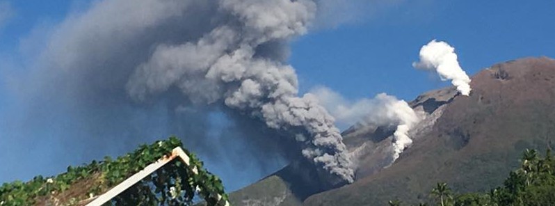
Featured image: Bulusan volcano eruption - October 16/17 2016. Credit: Drew Zuniga
Bulusan, Luzon's southernmost volcano, generated a minor phreatic eruption at 23:36 UTC on October 16, 2016 (07:36 PHT on October 17). At 00:11 UTC, ash plume was reaching an altitude of 2.7 km (9 000 feet) above sea level, the Tokyo VAAC reported.
According to the PHIVOLCS, the event lasted for approximately 24 minutes. The eruption originated from the southeast vent and produced a dirty-white to grayish ash column that reached a height of 1 km (3 280 feet) above the crater.
Bulusan’s seismic monitoring network recorded a total of 24 volcanic earthquakes between 01:00 UTC on October 16 and 17. Sulfur dioxide (SO2) emission was measured at an average of 79 tonnes/day on October 12, 2016. Precise leveling data obtained on August 16 – 25, 2016 indicated slight inflationary changes of the edifice relative to May 2016.
Moreover, ground deformation data from continuous GPS measurements as of September 30, 2016 showed inflationary trends since July 2016.
Alert Level 1 (abnormal) remains in effect, indicating that hydrothermal processes are underway beneath the volcano that may lead to more steam-driven eruptions, PHIVOLCS said.
"Local government units and the public are reminded that entry to the 4-kilometer [2.5 miles] radius Permanent Danger Zone (PDZ) is strictly prohibited due to the possibility of sudden and hazardous steam-driven or phreatic eruptions."
People living within valleys and along river/stream channels especially on the southwest and northwest sector of the edifice should be vigilant against sediment-laden stream flows and lahars in the event of heavy and prolonged rainfall.
I.5 km ash plume from the steam driven "phreatic" eruption of #Bulusan volcano at 4:54 PM today 16 Sept. 2016 pic.twitter.com/rtnjbFLJZo
— jaime s. sincioco (@jaimessincioco) September 16, 2016
Minor #phreatic eruption from SE vent of #Bulusan volcano at 7:36 AM 10/17/16 ejecting 1 km grayish ash column – Ocdv Jose Dee-five' photo pic.twitter.com/Dk3XSAbbfn
— jaime s. sincioco (@jaimessincioco) October 17, 2016
Geologic summary
Luzon's southernmost volcano, Bulusan, was constructed along the rim of the 11-km-diameter dacitic-to-rhyolitic Irosin caldera, which was formed about 36 000 years ago. Bulusan lies at the SE end of the Bicol volcanic arc occupying the peninsula of the same name that forms the elongated SE tip of Luzon. A broad, flat moat is located below the topographically prominent SW rim of Irosin caldera; the NE rim is buried by the andesitic Bulusan complex.
Bulusan is flanked by several other large intracaldera lava domes and cones, including the prominent Mount Jormajan lava dome on the SW flank and Sharp Peak to the NE. The summit of 1565-m-high Bulusan volcano is unvegetated and contains a 300-m-wide, 50-m-deep crater. Three small craters are located on the SE flank. Many moderate explosive eruptions have been recorded at Bulusan since the mid-19th century. (GVP)
The Watchers team and our contributors bring the latest on extreme weather, earthquakes, volcanic eruptions, space weather, and all things science. We're all about making sense of the natural world and keeping you informed on what’s happening. Got a tip or a question? Hit us up using the form at newstips!
Commenting rules and guidelines
We value the thoughts and opinions of our readers and welcome healthy discussions on our website. In order to maintain a respectful and positive community, we ask that all commenters follow these rules.