
PHIVOLCS raises alert status of Bulusan volcano, Philippines
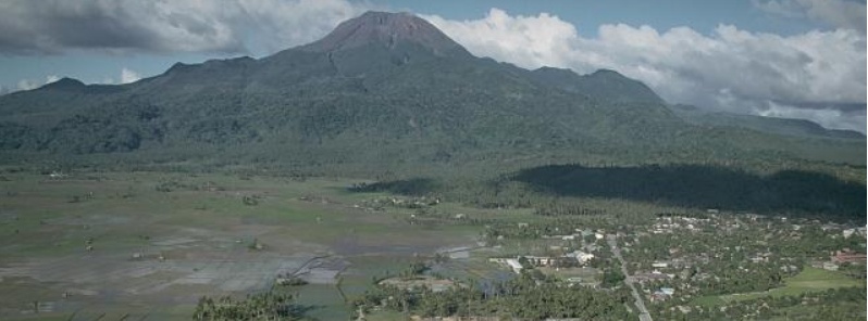
Image credit: USGS, Chris Newhall
The Philippine Institute of Volcanology and Seismology has raised the alert status of Bulusan volcano from Alert Level 0 (normal) to Alert Level 1 (abnormal) on July 6, 2020. The decision was made due to increased seismic activity under the volcano.
Bulusan's monitoring network recorded a total of 53 volcanic earthquakes from July 3 to 6, 2020 including 43 low-frequency events that are associated with weak and shallow hydrothermal or magmatic gas activity within the edifice.
The increased seismicity could be succeeded by steam-driven or phreatic eruptions at the summit crater or from flank vents on the upper to middle slopes, despite the absence of visible degassing or steaming from the active vents this year, experts at the institute noted.
Ground deformation data from continuous GPS measurements also indicate a short-term inflation of the edifice since late February 2020. These parameters indicate that volcanic processes are underway beneath the edifice that may be caused by deep-seated degassing or hydrothermal activity or magmatic intrusion.
Alert Level 1 (abnormal) status means that the volcano is currently in an abnormal condition.
Local government units and the public are reminded that entry into the 4 km (2.5 miles) radius Permanent Danger Zone (PDZ) is strictly prohibited and that vigilance within the 2 km (1.2 miles) Extended Danger Zone (EDZ) on the southeastern sector must be exercised due to the increased possibilities of sudden and hazardous phreatic eruptions.
Pilots are advised to avoid flying close to the volcano’s summit as ash from any sudden phreatic eruption can be hazardous to aircraft.
Furthermore, people living within valleys and along river/stream channels especially on the southeast, southwest and northwest sector of the edifice should be vigilant against sediment-laden stream flows and lahars in the event of heavy and prolonged rainfall.
Geological summary
Luzon's southernmost volcano, Bulusan, was constructed along the rim of the 11-km-diameter (6.8 miles) dacitic-to-rhyolitic Irosin caldera, which was formed about 36 000 years ago. Bulusan lies at the SE end of the Bicol volcanic arc occupying the peninsula of the same name that forms the elongated SE tip of Luzon. A broad, flat moat is located below the topographically prominent SW rim of Irosin caldera; the NE rim is buried by the andesitic Bulusan complex.
Bulusan is flanked by several other large intracaldera lava domes and cones, including the prominent Mount Jormajan lava dome on the SW flank and Sharp Peak to the NE. The summit of 1 565-m-high (5 134 feet) Bulusan volcano is unvegetated and contains a 300-m-wide (984 feet), 50-m-deep (164 feet) crater. Three small craters are located on the SE flank. Many moderate explosive eruptions have been recorded at Bulusan since the mid-19th century. (GVP)
I'm a dedicated researcher, journalist, and editor at The Watchers. With over 20 years of experience in the media industry, I specialize in hard science news, focusing on extreme weather, seismic and volcanic activity, space weather, and astronomy, including near-Earth objects and planetary defense strategies. You can reach me at teo /at/ watchers.news.
Commenting rules and guidelines
We value the thoughts and opinions of our readers and welcome healthy discussions on our website. In order to maintain a respectful and positive community, we ask that all commenters follow these rules.