
Extreme heat triggers heavy thunderstorms, UK
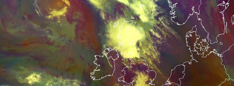
Image credit: EUMETSAT / Meteosat-10 RGB Airmass at 09:00 UTC on July 20, 2016
Colloquially, British summer is described as three nice days then a thunderstorm. It proved so again this week when the UK's hottest day of the year, July 19 (33.5 °C / 92.3 °F in Brize Norton, Oxfordshire), ended in heavy thundery weather in the country's north and west. At least three persons have lost their lives.
Although UK's record maximum temperature was measured on August 10, 2003, at Faversham in Kent at 38.5 °C (101.3 °F), the hottest day of the year so far, July 19, ended as everybody could expect, with dangerous thunderstorms and flooding.
Met Office issued a yellow warning across all regions other than southwest England, London, and southeast England. "Hot, moist air spreading north and north-east is expected to produce thunderstorms, with some places seeing around 30 mm (1.2 inches) of rainfall in an hour, and more than 50 mm (2 inches) in a few hours," the Office warned.
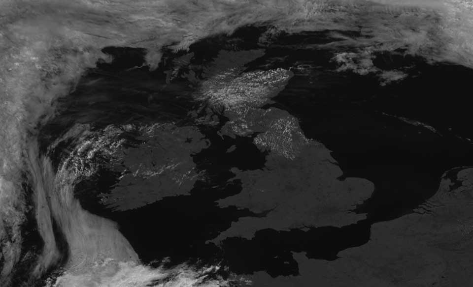
Meteosat-10 image taken at 10:45 UTC on July 19, 2016. Credit: EUMETSAT
In the Meteosat-10 HRV image taken at 10:45 UTC on July 19 (above), small convective clouds can be seen over northern England and Scotland. In the southwest corner of the image, an area of cirrus moved north, heralding some heavy thunderstorms which spread north during the night.
The Airmass RGB animation (below), from 18:00 UTC on July 19 to 09:00 UTC on July 20, shows a cold front moving northeast across the UK with heavy rain and thunderstorms breaking out over the northwest of England, Wales and Scotland.
Credit: EUMETSAT
Rainfall totals exceeded 50 mm (2 inches) in areas of Wales and northwest England, and more than 30 mm (1.2 inches) in places in Scotland.
A large mesoscale convective system (MCS) can be seen developing in the Irish sea and moving northeast over Scotland.
In Scotland's Denny, Stirlingshire, a church was hit by a bolt that sounded like a bomb and in Cove, Aberdeenshire, a house was badly damaged by a lightning strike. Thousands of drivers were forced to battle through floods in many areas of the country. Hailstones the size of golf balls fell in Gretna, Express.co.uk reports.
In Glasgow, the water hit such levels that shop staff on the south side of the city had to use sandbags to protect the properties. "It's horrendous. In the space of about 15 minutes the street was flooded," one witness said.
The Watchers team and our contributors bring the latest on extreme weather, earthquakes, volcanic eruptions, space weather, and all things science. We're all about making sense of the natural world and keeping you informed on what’s happening. Got a tip or a question? Hit us up using the form at newstips!
Commenting rules and guidelines
We value the thoughts and opinions of our readers and welcome healthy discussions on our website. In order to maintain a respectful and positive community, we ask that all commenters follow these rules.