
Magnitude 6.1 earthquake struck Luzon, Philippines
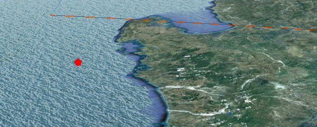
Image credit: Google Earth + USGS
Strong earthquake with magnitude 6.1 struck Luzon, Philippines on June 16, 2012 at 22:18 UTC according to USGS. Epicenter was located 94 km (58 miles) SW of Dagupan, Luzon, Philippines (15.574°N, 119.609°E). Recorded depth was 35.3 km (21.9 miles).
Philippine Institute of Volcanology and Seismology – PHIVOLCS is reporting 6.0 earthquake. No damage is expected from this one. Aftershocks are expected.
| Magnitude | 6.1 |
|---|---|
| Date-Time |
|
| Location | 15.574°N, 119.609°E |
| Depth | 35.3 km (21.9 miles) |
| Region | LUZON, PHILIPPINES |
| Distances | 94 km (58 miles) SW of Dagupan, Luzon, Philippines 109 km (67 miles) NW of Olongapo, Luzon, Philippines 115 km (71 miles) WNW of Angeles, Luzon, Philippines 182 km (113 miles) NW of MANILA, Philippines |
| Location Uncertainty | horizontal +/- 11.1 km (6.9 miles); depth +/- 6.6 km (4.1 miles) |
| Parameters | NST=294, Nph=299, Dmin=817.1 km, Rmss=0.96 sec, Gp= 22°, M-type=regional moment magnitude (Mw), Version=B |
| Source |
|
| Event ID | usb000ahkr |

Shake map

Population exposure

Selected cities exposed from GeoNames database of cities with 1,000 or more residents.
| MMI | City | Population |
|---|---|---|
| IV | Bani | 3k |
| IV | Bolitoc | 3k |
| IV | Lipay | 3k |
| IV | Taltal | 5k |
| IV | Palauig | 3k |
| IV | Lucapon | 6k |
| III | Manila | 10,445k |
| III | Makati | 0 |
| III | Pasig | 0 |
| III | Tabuk | 27k |
| III | Kabugao | 2k |

Historical seismicity – 2012

This area is on the Manila Trench, an oceanic trench in the South China Sea, located west of the islands of Luzon and Mindoro in the Philippines. The trench reaches a depth of about 5,400 metres (17,700 ft), in contrast with the average depth of the South China Sea of about 1,500 metres (4,900 ft). It is created by subduction, in which the Sunda Plate (part of Eurasian Plate) is subducting under the Philippine Mobile Belt, producing this almost N-S trending trench. Theconvergent boundary is terminated to the north by the Taiwan collision zone, and to the south by the Mindoro terrane (Sulu-Palawan block colliding with SW Luzon). It is an area pervaded by negative gravity anomalies.
The Manila Trench is associated with frequent earthquakes, and the subduction zone is responsible for the belt of volcanoes on the west side of the Philippine island of Luzon, which includes Mount Pinatubo.
Convergence between the Philippine Mobile Belt and the Sunda Plate have been estimated using GPS measurements, and this value ranges from ~ 50+ mm/yr in Taiwan, to 100 mm/yr near N. Luzon, and ~ 50 mm/yr near Zambales and ~20+mm/yr near Mindoro island. Plate locking between the Sunda Plate and Luzon is about 1% coupled, almost unlocked as determined by elastic block models, suggesting that the trench absorbs the Philippine Mobile Belt-Eurasian Plate convergence.

I'm a dedicated researcher, journalist, and editor at The Watchers. With over 20 years of experience in the media industry, I specialize in hard science news, focusing on extreme weather, seismic and volcanic activity, space weather, and astronomy, including near-Earth objects and planetary defense strategies. You can reach me at teo /at/ watchers.news.
Commenting rules and guidelines
We value the thoughts and opinions of our readers and welcome healthy discussions on our website. In order to maintain a respectful and positive community, we ask that all commenters follow these rules.