
Shallow M7.6 earthquake hits near the coast of Mindanao, Philippines – tsunami waves produced
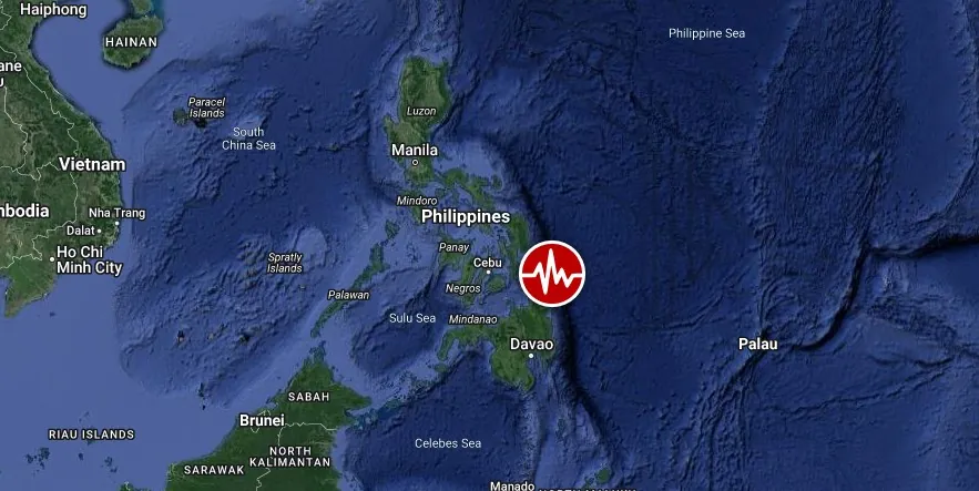
Image credit: TW/SAM, Google
A powerful earthquake registered by the USGS as M7.6 hit near the coast of Mindanao, Philippines at 14:37 UTC (22:37 local time) on December 2, 2023. The agency is reporting a depth of 32.8 km (20.4 miles). EMSC is reporting M7.5 at a depth of 63 km (39 miles); PHIVOLCS M7.4 a ta depth of 26 km (15 miles).
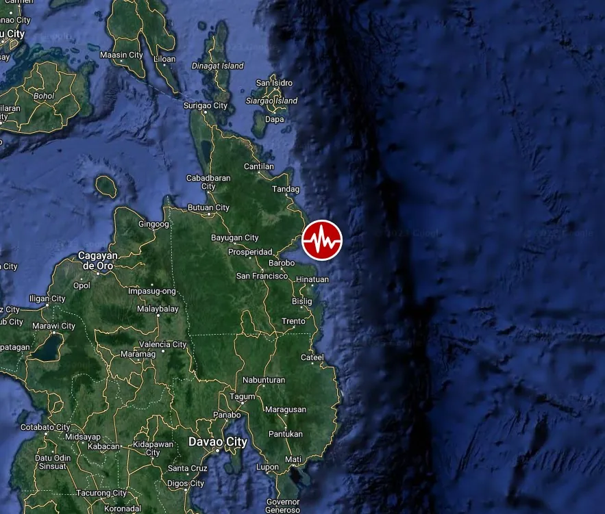
The epicenter was located 21.3 km (13.2 miles) NE of Hinatuan (population 10 055), 31.6 km (19.7 miles) ENE of Tagbina (population 10 672), 37.6 km (23.4 miles) NNE of Bislig (population 67 567), 40.7 km (25.3 miles) ESE of Lianga (population 13 623), and 110.1 km (68.4 miles) ESE of Butuan (population 309 709), Caraga, Philippines.
1.7 million people are living within 100 km (62 miles).
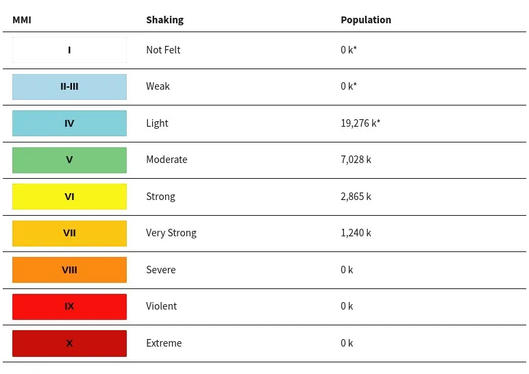
1 240 000 people are estimated to have felt very strong shaking, 2 865 000 strong, 7 028 000 moderate and 19 275 000 light.
Based on preliminary earthquake parameters, hazardous tsunami waves are possible for coasts located within 1 000 km (620 miles) of the earthquake epicenter, NWS PTWC in Honolulu said at 14:44 UTC.
Estimated times of arrival -ETA- of the initial tsunami wave for places with a potential tsunami threat. (Actual arrival times may differ and the initial wave may not be the largest. A tsunami is a series of waves and the time between waves can be five minutes to one hour.)
| Location | Region | Coordinates | ETA (UTC) |
|---|---|---|---|
| Davao | Philippines | 6.8N 125.7E | 1520 12/02 |
| Geme | Indonesia | 4.6N 126.8E | 1520 12/02 |
| Berebere | Indonesia | 2.5N 128.7E | 1533 12/02 |
| Tabukan Tengah | Indonesia | 3.6N 125.6E | 1535 12/02 |
| Legaspi | Philippines | 13.2N 123.8E | 1538 12/02 |
| Cotabuto City | Philippines | 7.2N 124.2E | 1556 12/02 |
| Manado | Indonesia | 1.6N 124.9E | 1557 12/02 |
| Patani | Indonesia | 0.4N 128.8E | 1602 12/02 |
| Malakal | Palau | 7.3N 134.5E | 1618 12/02 |
| Maimbung | Philippines | 5.9N 121.0E | 1650 12/02 |
| Zamboanga | Philippines | 7.0N 122.3E | 1650 12/02 |
| Puerto Princesa | Philippines | 9.8N 118.8E | 1749 12/02 |
| Iloilo | Philippines | 10.7N 122.5E | 1802 12/02 |
| Sandakan | Malaysia | 5.9N 118.1E | 1840 12/02 |
| Manila | Philippines | 14.6N 121.0E | 1929 12/02 |
| Lahad Datu | Malaysia | 4.9N 118.4E | 1931 12/02 |
- A tsunami is a series of waves. The time between wave crests can vary from 5 minutes to an hour. The hazard may persist for many hours or longer after the initial wave.
- Impacts can vary significantly from one section of coast to the next due to local bathymetry and the shape and elevation of the shoreline.
- Impacts can also vary depending upon the state of the tide at the time of the maximum tsunami waves.
- Persons caught in the water of a tsunami may drown, be crushed by debris in the water, or be swept out to sea.
In an update posted at 15:35 UTC, NWS PTWC said tsunami waves reaching 1 to 3 m (3.3 – 10 feet) above the tide level are possible along some coasts of the Philippines. Tsunami waves reaching 0.3 to 1 m (1 – 3.3 feet) are possible for some coats of Palau.
Tsunami waves are forecast to be less than 0.3 m (1 feet) above the tide level for the coasts of American Samoa, China, Chuuk, Cook Islands, Fiji, French Polynesia, Guam, Hawaii, Howland and Baker, Indonesia, Japan, Jarvis Island, Johnston Atoll, Kiribati, Kosrae, Malaysia, Marshall Islands, Midway Island, Nauru, Northern Marianas, Northwestern Hawaiian Islands, Palmyra Island, Papua New Guinea, Pohnpei, Republic of Korea, Samoa, Solomon Islands, Taiwan, Tokelau, Tonga, Tuvalu, Vanuatu, Wake Island, Wallis and Futuna, and Yap.
In an update posted at 16:45 UTC, PTWC said the tsunami threat from this earthquake has now passed. “There is no longer a tsunami threat from this earthquake.” However, residents in the affected region are recommended to remain observant and exercise normal caution near the sea.
The USGS issued a Green alert for shaking-related fatalities. There is a low likelihood of casualties.
A Yellow alert was issued for economic losses. Some damage is possible and the impact should be relatively localized. Estimated economic losses are less than 1% of GDP of Philippines. Past events with this alert level have required a local or regional level response.
Overall, the population in this region resides in structures that are a mix of vulnerable and earthquake-resistant construction. The predominant vulnerable building types are unknown/miscellaneous types and heavy wood frame construction.
Recent earthquakes in this area have caused secondary hazards such as tsunamis and landslides that might have contributed to losses.
Liquefaction triggered by this earthquake is estimated to be extensive in severity and (or) spatial extent, according to the USGS. The number of people living near areas that could have produced liquefaction in this earthquake is extensive (≥ 1 000 000). This is not a direct estimate of liquefaction fatalities or losses.
Little or no landsliding is expected, but some landslides could have occurred in highly susceptible areas.
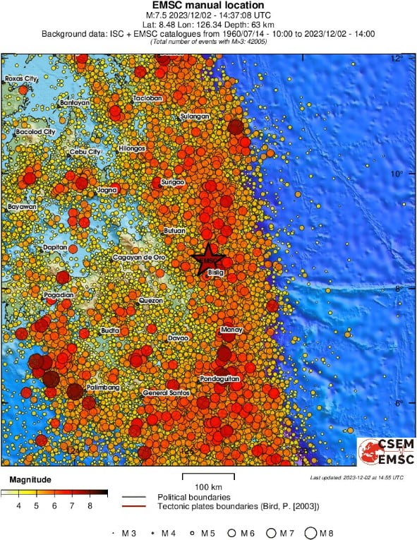
PHIVOLCS said the quake was associated with the subduction along the Philippine Trench.
Waves of 40 cm (1.3 feet) were observed on Japan’s Hachijojima island, some 290 km (180 miles) south of Tokyo, according to the Japan Meteorological Agency (JMA).
Raymark Gentallan, the police chief in Hinatuan (population 44 000), a coastal town situated approximately 30 km (19 miles) from the epicenter of the earthquake, reported a power outage in the area since the quake struck.
Significant damage was reported in places, but the full extent of the damage is still being assessed.
Reports on Sunday, December 3, mention at least one fatality — a woman who was killed when a wall collapsed as she and her family were fleeing their home in search of safety in Tagum City. At least 4 people were injured and 9 are missing.
According to Defence Secretary Gilbert Teodoro, 529 families were affected.
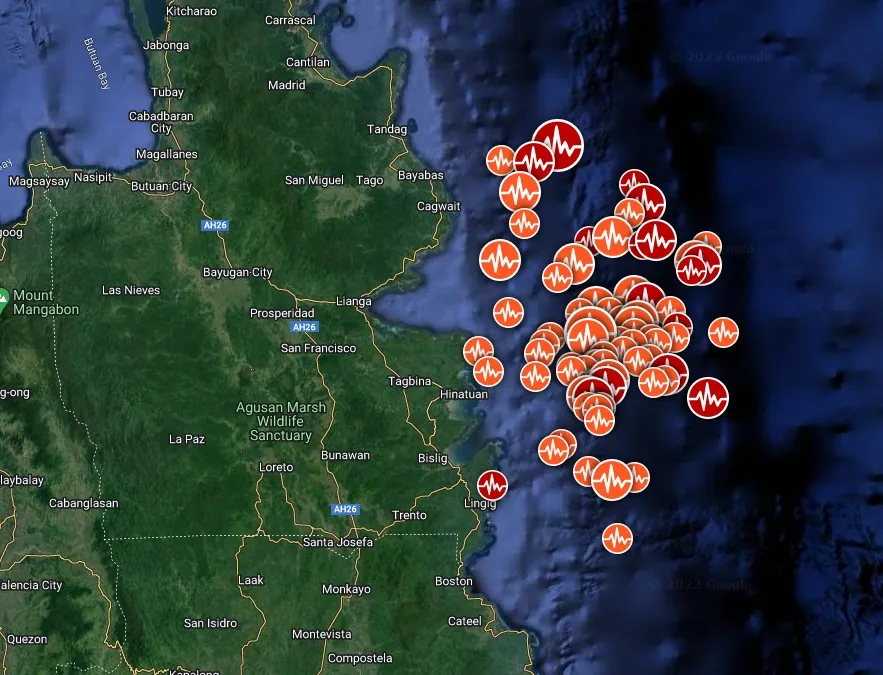
Aftershocks
At least 71 aftershocks with magnitudes above 4.5 were registered until 06:18 UTC on December 3. The strongest ones included an M5.8 at 15:06 UTC, M6.4 at 16:03, M6.2 at 17:40, M6.2 at 18:09, and M6.0 at 20:52.
PHIVOLCS registered hundreds of smaller earthquakes.
M6.6 aftershock was recorded by the USGS at 10:35 UTC on December 3. This one was followed by numerous M4.5 -5.6 until M6.9 hit at 19:49 UTC.
By 21:00 UTC on December 3, the USGS registered a total of 80 aftershocks with magnitudes above 4.5.
Moderate to strong aftershocks could persist for several days to months, PHIVOLCS said.
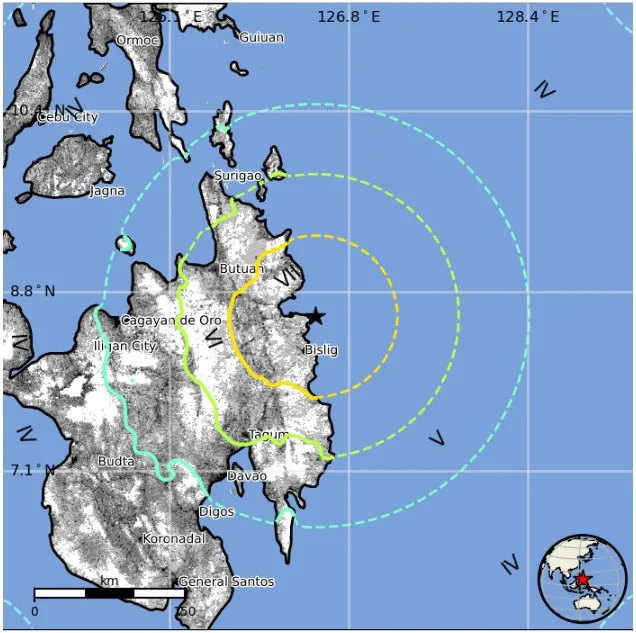
Estimated population exposure to earthquake shaking
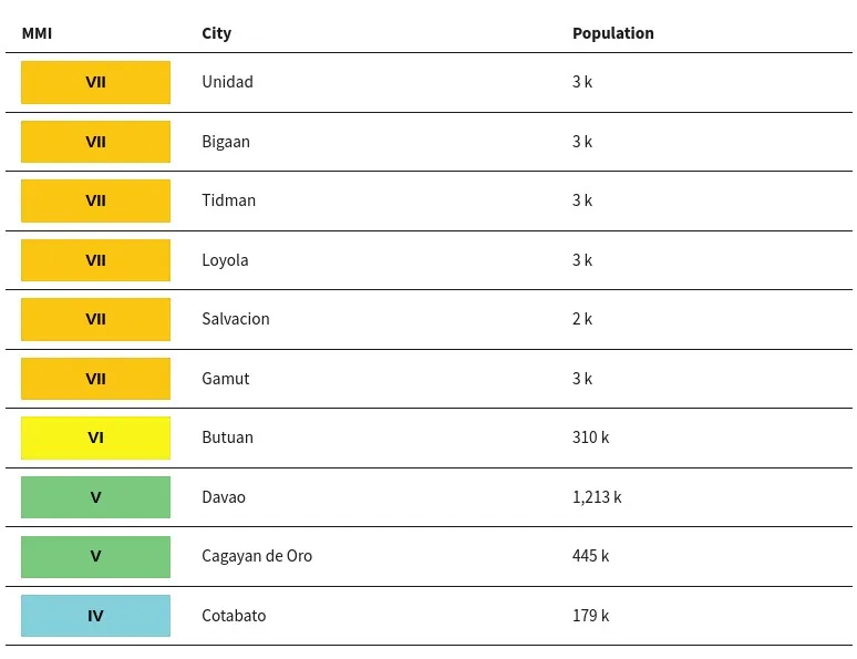
Selected cities exposed
Regional seismicity
Multimedia
#VIDEO| Momento de cómo se sintió el #sismo magnitud 7.6 en zonas públicas de #Mindanao, #Filipinas.
— quiero tv (@quierotv_gdl) December 2, 2023
📹: Redes Sociales. pic.twitter.com/VAUfNg3dEH
Video shows the strength of tremors in #Philippines as south east Asian is rocked by series of earthquakes.
— Gautam Varma (@IamGautamVarma) December 2, 2023
More and more videos are pouring in revealing the intensity of massive shocks above reading 7 on Richter scale.
#EarthquakePH #earthquake #Tsunami pic.twitter.com/nIXdP8Ym3m
PHIVOLCS has issued a #Tsunami Warning for the #Philippines after the powerful #earthquake (#lindol) in #Mindanao. People in the Philippines and nearby countries need to check local authorities for local tsunami information and the aftershocks of the earthquake. #sismo #quake https://t.co/YEsbKT3sVs pic.twitter.com/TlCo8Y0lsR
— 🌊 Earthquake Updates Worldwide – #StopWar 🎗️ (@InfoEarthquakes) December 2, 2023
I'm a dedicated researcher, journalist, and editor at The Watchers. With over 20 years of experience in the media industry, I specialize in hard science news, focusing on extreme weather, seismic and volcanic activity, space weather, and astronomy, including near-Earth objects and planetary defense strategies. You can reach me at teo /at/ watchers.news.
Commenting rules and guidelines
We value the thoughts and opinions of our readers and welcome healthy discussions on our website. In order to maintain a respectful and positive community, we ask that all commenters follow these rules.