
Flooding in Southeastern Australia
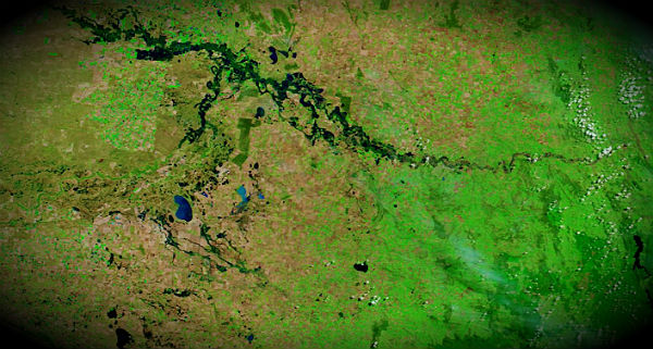
Image credit: TW
Rising waters flooded parts of New South Wales and Victoria, Australia, in March 2012, forcing some residents to evacuate their homes. On March 15, evacuation orders were lifted for the northern Victoria town of Nathalia, which had faced possible inundation. Although allowed to return home, residents were warned to stay vigilant for rapidly rising waters, news reports said.

In late February, most of the area pictured in these scenes was relatively dry, with little standing water. By mid-March, the situation had changed significantly. High water not only surrounded Nathalia in Victoria, but also swelled the Murrumbidgee River in New South Wales. The widespread flooding followed a prolonged regional drought, known as Big Dry, lasting from 1997 to 2011. (EarthObservatory)
The weather bureau has forecast rains of 30mm to 50mm for the state’s northeast catchments on Thursday and into Friday, with higher totals possible on the ranges. Although water levels are receding slowly in the Broken Creek catchment, areas of flooding are expected to continue into next week.
Commenting rules and guidelines
We value the thoughts and opinions of our readers and welcome healthy discussions on our website. In order to maintain a respectful and positive community, we ask that all commenters follow these rules.