
Magnitude 6.2 – Xinjiang, China
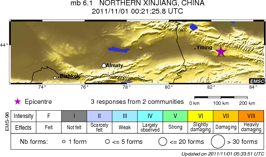
Image credit: TW
USGS has recalculated the magnitude and reports now a 5.4 magnitude earthquake located 95 km (59 miles) ESE of Yining, 289 km (179 miles) SW of Karamay, Xinjiang, 302 km (187 miles) WSW of Shihezi, Xinjiang, China at depth of 27.9 km (17.3 miles).


EMSC registered magnitude 6.1 at depth of 10 km. GFZ reports a 6.0 magnitude at depth of 10 km. CEN ‘China Earthquake Network) has also updates its data and reports now a magnitude of 6.0 at depth of 28 km, far less dangerous than the initial values mainly because of the deeper hypocenter.
The preliminary epicenter location looks to be very close to Walixiang and Qinghuan. The preliminary magnitude of this Xinjiang earthquake has been set to 6.2 at a depth of 10 km . 92 km E Yining (pop 257,671)
Google satellite map showing the epicenter and the surrounding area
A landslide has blocked a section of a highway, schools have been temporarily closed in the area. There was damage to agricultural facilities. (EarthquakeReport)
In 1976 a 6.4 magnitude earthquake at a distance of 104 km from the current epicenter killed 41 people.

XinhuaNews Agency reports earthquake measuring 5.4 on the Richter scale located at the border area of Sichuan and Gansu provinces in western China at 5:58 a.m. Tuesday Beijing Time, according to the China Earthquake Networks Center.
The epicenter, with a depth of 20 km, was monitored at about 32.6 degrees north latitude and 105.3 degrees east longitude, the center said in a statement. The epicenter was located at the border area of Qingchuan County in the city of Guangyuan in Sichuan and Wenxian County in the city of Longnan in Gansu.

All villages in Wenxian County with communication services have reported no casualties, said Liu Huiping, head of Zhongmiao Township in Wenxian. In a related development, another earthquake measuring 6.0 on the Richter scale jolted Kazak Autonomous Prefecture of Ili, northwest China’s Xinjiang Uygur Autonomous Region at 8:21 a.m. Tuesday Beijing Time. The epicenter, with a depth of 10 km, was monitored at about 43.6 degrees north latitude and 82.4 degrees east longitude, according to the China Earthquake Networks Center.
Commenting rules and guidelines
We value the thoughts and opinions of our readers and welcome healthy discussions on our website. In order to maintain a respectful and positive community, we ask that all commenters follow these rules.