
Swarm of earthquakes shakes Turkey
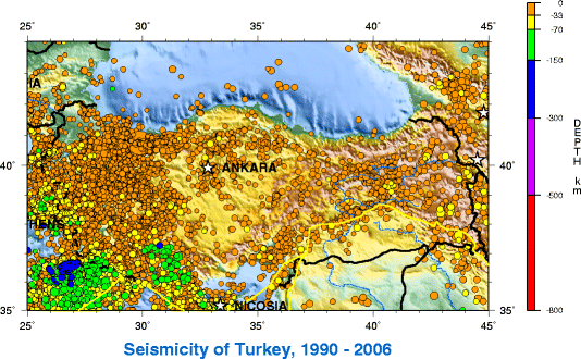
Image credit: TW
A 5.9-magnitude earthquake partially collapsed buildings in western Turkey on Friday, killing at least five people and injuring more than 70, according to authorities.
Close to a hundred aftershocks have followed a M5.9 earthquake. Turkey is the fulcrum point of several conjoining tectonic plates. The stresses on the landmass is inordinately great and this region will only grow more seismically unstable and dangerous with time.

Turkey's varied landscapes are the product of complex earth movements that have shaped Anatolia over thousands of years and still manifest themselves in fairly frequent earthquakes and occasional volcanic eruptions. Except for a relatively small portion of its territory along the Syrian border that is a continuation of the Arabian Platform, Turkey geologically is part of the great Alpine belt that extends from the Atlantic Ocean to the Himalaya Mountains. This belt was formed during the Tertiary Period (about 65 million to 1.6 million B.C.), as the Arabian, African, and Indian continental plates began to collide with the Eurasian plate, and the sedimentary layers laid down by the prehistoric Tethyan Sea buckled, folded, and contorted.
The intensive folding and uplifting of this mountain belt was accompanied by strong volcanic activity and intrusions of igneous rock material, followed by extensive faulting during the Quaternary Period, which began about 1.6. million B.C. This folding and faulting process is still at work, as the Turkish and Aegean plates, moving south and southwest, respectively, continue to collide. As a result, Turkey is one of the world's more active earthquake and volcano regions.

Earthquakes range from barely perceptible tremors to major movements measuring five or higher on the open-ended Richter scale. Earthquakes measuring more than six can cause massive damage to buildings and, especially if they occur on winter nights, numerous deaths and injuries. Turkey's most severe earthquake in the twentieth century occurred in Erzincan on the night of December 28-29, 1939; it devastated most of the city and caused an estimated 160,000 deaths. Earthquakes of moderate intensity often continue with sporadic aftershocks over periods of several days or even weeks. The most earthquake-prone part of Turkey is an arc-shaped region stretching from the general vicinity of Kocaeli to the area north of Lake Van on the border with Armenia and Georgia.
Turkey's terrain is structurally complex. A central massif composed of uplifted blocks and downfolded troughs, covered by recent deposits and giving the appearance of a plateau with rough terrain, is wedged between two folded mountain ranges that converge in the east. True lowland is confined to the Ergene Plain in Thrace, extending along rivers that discharge into the Aegean Sea or the Sea of Marmara, and to a few narrow coastal strips along the Black Sea and Mediterranean Sea coasts.

Nearly 85 percent of the land is at an elevation of at least 450 meters; the median altitude of the country is 1,128 meters. In Asiatic Turkey, flat or gently sloping land is rare and largely confined to the deltas of the Kizilirmak River, the coastal plains of Antalya and Adana, and the valley floors of the Gediz River and the Büyükmenderes River, and some interior high plains in Anatolia, mainly around Tuz Gölü (Salt Lake) and Konya Ovasi (Konya Basin). Moderately sloping terrain is limited almost entirely outside Thrace to the hills of the Arabian Platform along the border with Syria.
More than 80 percent of the land surface is rough, broken, and mountainous, and therefore is of limited agricultural value. The terrain's ruggedness is accentuated in the eastern part of the country, where the two mountain ranges converge into a lofty region with a median elevation of more than 1,500 meters, which reaches its highest point along the borders with Armenia, Azerbaijan, and Iran. Turkey's highest peak, Mount Ararat (Agri Dagi)–about 5,166 meters high–is situated near the point where the boundaries of the four countries meet. (CountryStudies)
I have kept USGS up in real time for several months. Until a week ago we were averageing 1.2- 6.0+ quakes per day. The last event of this magnitude in six days was the India quake on the 18th. Total number 2.5 or greater has fallen off dramaticly as well. Has anyone else noticed this?
…hope it isn’t the calm before the storm…
The Shift is certainy happening. May those who seek P E A C E, find it. And for goodness sake raise your vibrations !!!!