Skip to content !– Comets and asteroids –>
Support global hazard monitoring — Join 112 supporters
Go ad-free
0% 25% 50% 75% 100%
watchers.news
  • EarthExpand
    • Earth system monitoring

      Earth

      Monitoring significant geologic, atmospheric, hydrological, and surface hazards worldwide.

      View Earth coverage →
      Geologic hazards
      • Earthquakes
      • Volcanoes
      • Tsunami
      • Landslides
      • Sinkholes
      Severe weather
      • Severe storms
      • Tropical cyclones
      • Tornadoes
      • Blizzards
      • Heat waves
      Surface hazards
      • Floods
      • Drought
      • Wildfires
      • Avalanches
      • Ice & snow
      Support Watchers
      Support our monitoring and reporting work.
      Subscribe →
      Newsletter
      Get curated updates on global hazards.
      Join newsletter →
      Report an event
      Share local event information with our editors.
      Send report →
      Article archive
      Browse the full article archive.
      View archive →
  • SpaceExpand
    • Space environment

      Space

      Monitoring near-Earth space, celestial objects and orbital activity.

      View Space coverage →
      Solar System objects
      • Comets and asteroids
      • Near-Earth Objects
      Sky observation
      • Meteor activity
      • Night Sky
      Support Watchers
      Support our monitoring and reporting work.
      Subscribe →
      Newsletter
      Get curated updates on global hazards.
      Join newsletter →
      Report an event
      Share local event information with our editors.
      Send report →
      Article archive
      Browse the full article archive.
      View archive →
  • Space weatherExpand
    • Solar-terrestrial monitoring

      Space weather

      Monitoring solar activity, geomagnetic storms, radiation events, and near-Earth space conditions.

      View Space weather coverage →
      Space weather
      • Solar activity
      • Geomagnetic storms
      • Solar radiation storms
      SWX monitor

      Track solar activity, geomagnetic conditions, radiation storms, and near-Earth space weather signals in one place.

      Open SWX monitor →
      Support Watchers
      Support our monitoring and reporting work.
      Subscribe →
      Newsletter
      Get curated updates on global hazards.
      Join newsletter →
      Report an event
      Share local event information with our editors.
      Send report →
      Article archive
      Browse the full article archive.
      View archive →
  • Epicenter
  • ToolsExpand
    • Watchers tools

      Monitoring tools

      Operational tools supporting Watchers reporting, monitoring, and situational awareness.

      watchers.LIVE

      Near real-time hazard monitoring and situational intelligence.

      Open platform →

      SWX

      Space weather, solar activity, and geomagnetic conditions.

      Open SWX →

      SAM

      Earthquake monitoring and seismic signal tracking.

      Open SAM →

      StormWall

      Curated stormchaser videos documenting severe weather.

      Open StormWall →
  • ConnectExpand
    • Connect

      Support, updates, and contact

      Ways to support Watchers, receive updates, send event reports, and reach the editorial team.

      Subscribe

      Support our monitoring and reporting work.

      Choose support level →

      Newsletter

      Get curated updates on global hazards.

      Join newsletter →

      Report an event

      Share local event information with our editors.

      Report an event →

      Feeds and contact

      Follow Watchers by RSS or contact our editorial team.

      RSS feeds → Contact →
watchers.news
Home / us weather - Page 48

us weather

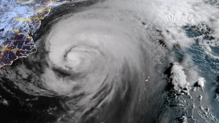
  • Satellite image of Hurricane Erin as of 10:20 UTC on August 21, 2025. Credit GOES-19, RAMMB/CIRA, The Watchers

    North Carolina highway closed following Hurricane Erin’s closest approach to U.S. Coast

    ByRishav Kothari Thursday, August 21, 2025Thursday, August 21, 2025

    Hurricane Erin made its closest approach to the U.S. coast overnight on August 19–20, 2025, closing part of North Carolina Highway 12 and prompting evacuations in coastal counties. Over 70 rip current rescues were reported along North Carolina beaches as the system brought storm surge, coastal flooding, and overwash to the Outer Banks.

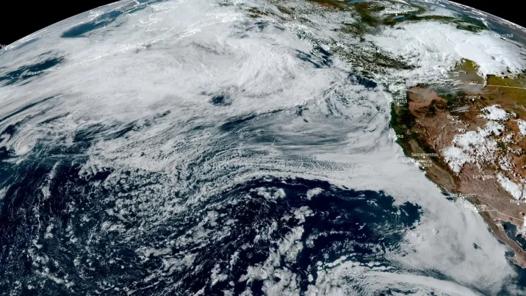
  • satellite image of atmospheric river impacting pacific northwest on august 14 2025

    Unusually strong summer atmospheric river brings heavy rainfall to Washington

    ByTeo Blašković Wednesday, August 20, 2025Wednesday, August 20, 2025

    An unusually strong summer atmospheric river made landfall over the Pacific Northwest late on August 14, 2025, reaching AR 3 along the Washington coast and producing 75–200 mm (3–8 inches) of rain across parts of western Washington.

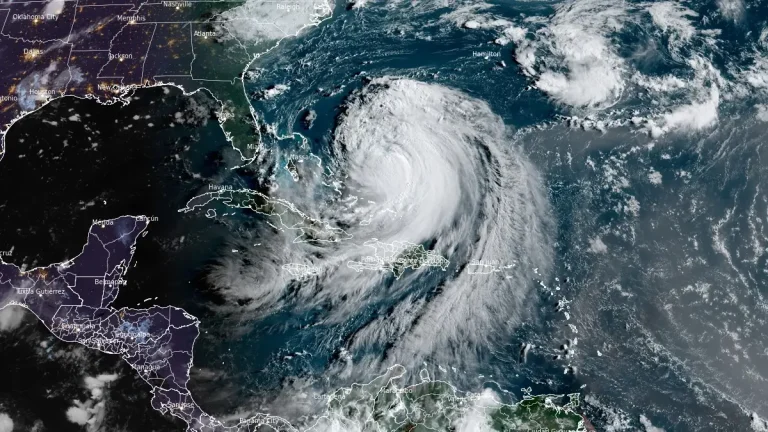
  • Satellite image of Hurricane Erin at 11:40 UTC on August 19, 2025

    Dangerous rip currents expected along U.S. East Coast as Hurricane Erin grows in size

    ByReet Kaur Tuesday, August 19, 2025Tuesday, August 19, 2025

    Tropical Storm Erin is forecast to grow substantially over the western Atlantic this week, producing dangerous surf, rip currents, and a possible storm surge of 0.6 to 1.2 m (2–4 feet) from Cape Lookout to Duck, North Carolina, as it approaches the U.S. East Coast, the Bahamas, Bermuda, and Atlantic Canada.

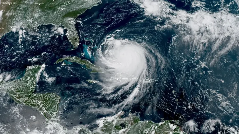
  • hurricane erin 1850z august 18 2025

    Category 4 Hurricane Erin located just east of southeast Bahamas, life-threatening surf expected along U.S. East Coast

    ByReet Kaur Monday, August 18, 2025Monday, August 18, 2025

    Category 4 Hurricane Erin was located 220 km (140 miles) north-northeast of Grand Turk Islands at 18:00 UTC (14:00 EDT) on August 18, 2025, with maximum sustained winds of 220 km/h (140 mph), maintaining Category 4 strength while moving northwest at 20 km/h (13 mph).

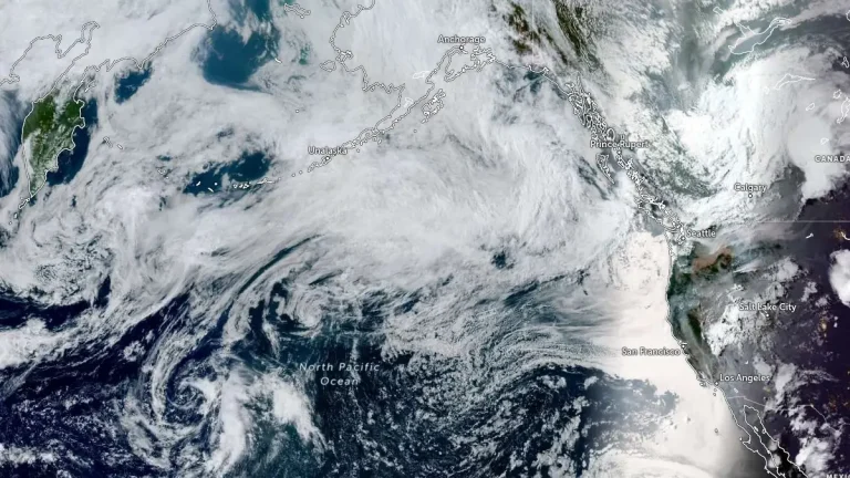
  • pacific ocean satellite image 0120 utc august 14 2025

    Moderate-to-strong atmospheric river to impact Pacific Northwest and southern British Columbia

    ByTeo Blašković Thursday, August 14, 2025Thursday, August 14, 2025

    An atmospheric river (AR) with moderate-to-strong integrated vapor transport (IVT) exceeding 500 kg m⁻¹ s⁻¹ is forecast to make landfall over the Pacific Northwest and southern British Columbia on the evening of August 14, 2025, bringing sustained AR conditions for about 24 hours and significant precipitation through August 16.

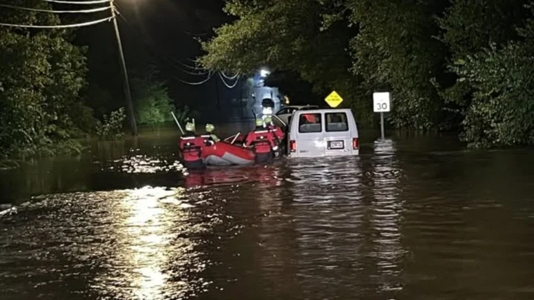
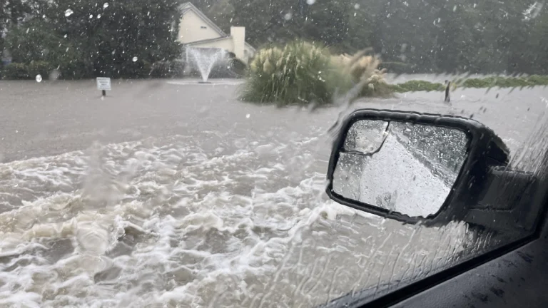
  • Flooded road in Tennessee on August 12 2025

    Three killed, one missing as flash flooding prompts state of emergency in Chattanooga, Tennessee

    ByReet Kaur Wednesday, August 13, 2025Wednesday, August 13, 2025

    Widespread flash flooding struck Chattanooga, Tennessee, on August 12, 2025, after 160 mm (6.4 inches) of rain fell in a single day, prompting a local state of emergency, multiple rescues, and resulting in three fatalities and one missing person.

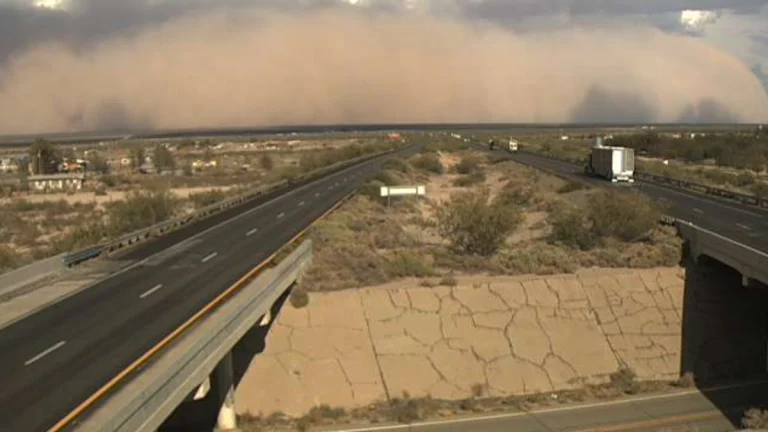
  • new mexico dust storm august 12 2025

    Severe dust storm with near-zero visibility closes section of Interstate 10 in New Mexico

    ByReet Kaur Wednesday, August 13, 2025Wednesday, August 13, 2025

    A severe dust storm produced near-zero to zero visibility along Interstate 10 between Lordsburg and Deming, New Mexico, at about 17:30 local time (LT) on August 12, 2025, prompting a full closure of the corridor between mile markers 20 and 81, roughly 98 km (61 miles). Conditions improved in the area by 18:30 LT.

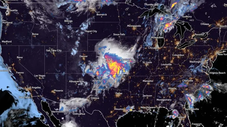
  • usa satellite image with rainfall radar at 1010 utc on august 11 2025

    Severe thunderstorms and excessive rainfall forecast across the central Plains, Midwest, and Southeast, U.S.

    ByReet Kaur Monday, August 11, 2025Monday, August 11, 2025

    Severe thunderstorms with large hail and damaging winds are forecast to impact parts of the central and southern Plains, U.S., this morning, August 11, 2025, as an upper-level disturbance from the central Rockies interacts with a slow-moving frontal boundary.

  • Nebraska storm damage

    One dead, one critically injured after large tree falls on vehicle during severe storms in Waterloo, Nebraska

    ByReet Kaur Sunday, August 10, 2025Sunday, August 10, 2025

    A woman was killed and a man critically injured on August 9, 2025, when a large tree fell on their vehicle at Two Rivers State Park near Waterloo, Nebraska, during severe storms.

  • satellite image with rainfall radar usa milwaukee 1340 utc on august 10 2025

    Historic flooding hits Milwaukee region after record-breaking rainfall, Wisconsin

    ByTeo Blašković Sunday, August 10, 2025Sunday, August 10, 2025

    Milwaukee recorded its second-wettest day on August 9, 2025, with 146 mm (5.74 inches) of rain causing historic flooding across the city and nearby areas.

  • Page navigation

    Previous PagePrevious 1 … 46 47 48 49 50 … 174 Next PageNext

    Subscribe


    Support our work — subscribe to unlock all articles and apps, ad-free. View all benefits.

    Latest articles

    Scientists find evidence of early continental rifting beneath Zambia

    May 13, 2026

    Series of tremors near Tehran renews focus on capital’s seismic risk, Iran

    May 13, 2026

    Rare tornado damages flower nurseries and greenhouses in Fujian, China

    May 13, 2026

    Asteroid 2026 JH2 to fly past Earth at 0.24 lunar distances

    May 13, 2026

    Rare volcanic ash emission detected from submarine volcano in Central Bismarck Sea, Papua New Guinea

    May 13, 2026

    Major spring storm forecast over parts of Alberta and Saskatchewan, Canada

    May 13, 2026

    Long dormant Methana volcano was accumulating magma for over 100 000 years

    May 12, 2026

    From the same category

    Tornadoes

    EF-3 tornado confirmed near Cream, Wisconsin during April 17, 2026 outbreak; NWS La Crosse issues record 26 warnings

    April 19, 2026
    Featured articlesSevere storms

    Tornadoes damage homes and infrastructure across multiple Midwest states on April 17

    April 18, 2026
    Severe storms

    Tornado Watch issued for parts of Iowa, Illinois, Minnesota, Missouri and Wisconsin

    April 17, 2026
    Featured articlesSevere storms

    Strong tornadoes, large hail and damaging winds expected from Plains to Great Lakes on April 17

    April 17, 2026

    Most read

    • 24 hours
    • 7 days
    • 30 days

    Subscribe to our newsletter

    Use the form below to have our daily news roundup delivered to your inbox every day at midnight UTC.

    The newsletter is free and you can unsubscribe anytime.


    Thank you!

    You have successfully joined our subscriber list.

    .

    • About us
    • Contact us
    • Updates & announcements
    • Terms & conditions
    • Privacy policy
    • Cookie policy
    • Editorial policy
    • Advertise
    • Support
    RSS X Facebook Telegram YouTube

    The Watchers — Watching the world evolve and transform

    Except where otherwise noted, content on this site is licensed under a Creative Commons Attribution-NonCommercial 4.0 International License - 2026

    Lost your password?


    Don't have an account yet? Sign up


    The Watchers
    Categories
    Earth
    Earthquakes Volcanoes Tsunami Landslides SinkholesSevere storms Tropical cyclones Tornadoes Blizzards Heat wavesFloods Drought Wildfires Avalanches Ice & snowView all Earth →
    Space
    Comets and asteroids Near-Earth Objects Meteor activity Night SkyView all Space →
    Space weather
    Solar activity Geomagnetic storms Solar radiation stormsView all Space weather →
    Epicenter
    Monitoring tools
    watchers.LIVE Near real-time hazard monitoring SWX Space weather monitoring SAM Seismic activity monitoring StormWall Severe weather video layer
    Get involved
    Report an event Report an event Share local event information with our editors. › Support Watchers Support Watchers Support our monitoring and reporting work. ›
    Email RSS X Facebook Telegram YouTube
    Search