• Strong East Coast atmospheric river forecast to bring heavy rain and snowmelt to Northeast

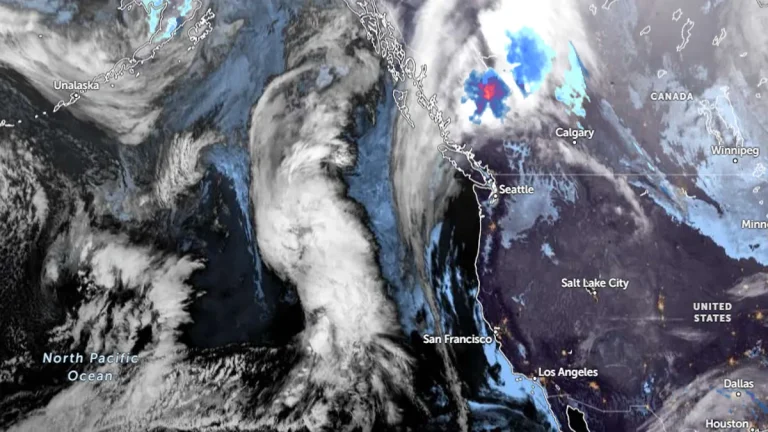
    A strong atmospheric river (AR) is set to impact the Southeastern and Northeastern U.S. this week, bringing anomalously high moisture levels and the potential for heavy rainfall and rapid snowmelt. Forecasts indicate the system will strengthen between December 10 and 11, driven by a plume of tropical moisture from the Gulf of Mexico and a cold front.

  • Atmospheric river forecast to make landfall over Washington and Oregon this weekend

    An atmospheric river is forecast to bring significant precipitation to Washington and Oregon between Friday and Saturday, December 6 and 7, 2024, with the Olympic Peninsula and North Cascades expecting up to 127 mm (5 inches) of rainfall and AR2 conditions likely in southern Washington and northern Oregon. While confidence is high regarding the occurrence of the event, uncertainties remain in its duration, intensity, and precise timing due to variability among GEFS ensemble model predictions.

  • Powerful atmospheric river hits Pacific Northwest, forecast to remain stationary over Northern California through November 22

    A powerful AR4 atmospheric river made landfall in the Pacific Northwest and Northern California on November 19, 2024, bringing prolonged rainfall, heavy snowfall, and significant flooding risks that are expected to worsen through November 22. Meteorologists warn that the storm could bring up to 380 mm (15 inches) of rain to the Coast Ranges and Sierra Nevada, with some areas potentially receiving more.

  • Atmospheric river may stall, causing long-duration moderate to heavy rain over parts of Oregon

    The National Weather Service (NWS) in Medford, Oregon, is warning residents that the incoming atmospheric river could stall across the region, leading to a prolonged period of moderate to heavy rainfall. The highest amounts are expected in Curry County, with a potential threat that the Coquille River at Coquille could reach a minor flood stage.

  • Model predicts major atmospheric river for Pacific Northwest and Northern California

    The latest model guidance suggests a major atmospheric river could hit the Pacific Northwest and Northern California early next week, with the ECMWF EPS control member forecasting AR3-4 conditions from central Oregon to Northern California. Although timing and duration remain uncertain, 70% of EPS members predict AR4 or AR5 conditions in coastal southern Oregon, according to the Center for Western Weather and Water Extremes (CW3E).

  • Significant rain and snow event expected for Northern California and Pacific Northwest

    A strong Atmospheric River is set to bring significant low-elevation rain and high-elevation snow to the Pacific Northwest and Northern California beginning Tuesday evening, November 12, 2024. The system will continue moving eastward, impacting a wide swath of the western and central United States with varied precipitation, including rain, snow, and thunderstorms.

  • Pacific Northwest and Northern California brace for incoming atmospheric rivers

    Two atmospheric rivers are set to bring heavy rainfall and flood risks to the Pacific Northwest and Northern California from November 10 to November 14. The storms are expected to bring significant precipitation, with the heaviest rainfall forecast for the Olympic Peninsula and Cascade Mountains. The peak rainfall is predicted to occur between November 10 and November 13.