
Why climate models disagree about the Pacific’s future may come down to the trade winds
A new Science Advances study finds that much of the disagreement among climate models over late-century eastern equatorial Pacific warming can be traced to two background properties: the strength of Pacific trade winds and effective climate sensitivity. Together, they explain about 74% of the model spread, offering a clearer physical reason why some models produce a much stronger El Niño-like shift than others.
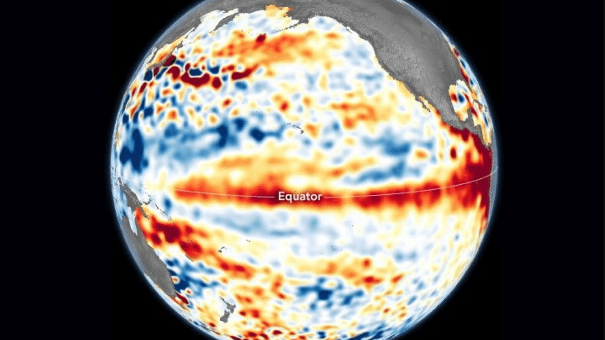
A new study links differences in Pacific trade-wind strength and effective climate sensitivity to much of the disagreement among climate models over the strength of future El Niño-like warming in the eastern equatorial Pacific. Credit: NASA Earth Observatory image by Lauren Dauphin, using modified Copernicus Sentinel data (2023) processed by the European Space Agency and further processed by Josh Willis, Severin Fournier, and Kevin Marlis (NASA/JPL-Caltech).
Jacob Stuivenvolt-Allen and Alexey V. Fedorov focused on a problem that has persisted across climate-model projections. Models broadly produce stronger relative warming in the eastern equatorial Pacific over the long term, creating what researchers call an El Niño-like mean state, but they disagree considerably over how large that east-west change becomes. The new study asks what inside the models controls that spread.
The result matters because the east-west temperature difference across the tropical Pacific helps organize one of the planet’s most influential ocean-atmosphere systems. Trade winds normally push warm surface water toward the western Pacific while cooler water rises farther east. Changes in that temperature contrast alter atmospheric circulation and are closely tied to the behavior of the El Niño-Southern Oscillation (ENSO), whose shifts can affect rainfall, drought, storms, and seasonal weather far beyond the tropical Pacific.
The first major control identified by the researchers is the background strength of the Pacific trade winds.

Under normal tropical Pacific conditions, easterly trade winds push warm surface water westward toward Asia. Cooler subsurface water rises in the eastern Pacific to replace it, helping maintain a pronounced temperature difference between the warmer west and cooler east. NOAA describes the same wind-driven circulation as a basic part of the physical setup behind ENSO.
In the models analyzed by Stuivenvolt-Allen and Fedorov, stronger background trade winds produced larger east-west contrasts in both sea-surface temperature and low-cloud cover. When the models were subjected to radiative forcing, those larger starting contrasts produced a greater weakening of the east-west temperature gradient.
Physically, a model with stronger normal trade winds starts with a more sharply divided tropical Pacific, with warm conditions concentrated farther west and cooler conditions maintained farther east. That initial state affects how strongly the ocean and atmosphere respond later.
The researchers traced part of the response to two interacting processes: low-cloud feedback and the Bjerknes feedback. The Bjerknes feedback is a self-reinforcing connection between Pacific temperatures and winds. A change in the east-west temperature difference alters the trade winds; the altered winds then change ocean circulation, upwelling, and sea-surface temperatures, feeding back into the original temperature pattern.
Stronger initial trade winds produced conditions in the experiments that allowed a larger reduction in the east-west temperature difference once the system was forced. The authors’ perturbation experiments were designed to test that physical mechanism rather than relying only on a statistical relationship across different models.
Trade winds were not the only control. The second was effective climate sensitivity (EffCS), a model-based estimate of how strongly global surface temperature responds to increased carbon dioxide before the climate system has fully reached equilibrium.
Background trade-wind strength and effective climate sensitivity together accounted for about 74% of the differences in projected eastern equatorial Pacific warming across the models examined.
The 74% result gives the study its main quantitative weight. Instead of leaving most of the spread among models unexplained, the analysis links it to two identifiable model characteristics with clear physical meaning.
The authors also used the relationship as what climate scientists call an emergent constraint. An emergent constraint connects something models simulate in the present climate with how strongly they respond in the future. If the present-day quantity can be measured in the real world, it can help narrow the range of model outcomes.
For this calculation, the researchers used an observation-based easterly wind stress of 0.043 newtons per square meter together with an effective climate sensitivity of 3.0°C under the SSP5-8.5 forcing scenario. The result concerns a reduction in the temperature difference between the western and eastern equatorial Pacific, not an equivalent amount of absolute warming at one location.
The phrase “El Niño-like” requires an important distinction. The study describes the average spatial pattern of the modeled tropical Pacific: the eastern side warms more strongly relative to the west, reducing the normal east-west temperature difference. It does not mean that one continuous El Niño event develops, nor does the 74% result by itself establish how frequently individual El Niño events will occur.
ENSO is an oscillation involving changes in both the ocean and atmosphere on much shorter timescales. During an actual El Niño, weakened trade winds allow warm surface water to spread eastward and suppress some of the normal cold-water upwelling in the eastern Pacific. The new study instead addresses how the background state of the Pacific evolves in long-term model experiments.
The result sits inside a broader unresolved Pacific-model problem. Long-term models generally produce a weakened east-west temperature gradient and stronger relative warming in the eastern equatorial Pacific, but the response can evolve differently over shorter timescales. A separate 2026 modeling study found that the gradient can initially strengthen before weakening decades later, with changing trade winds playing an important role in the transition.
That time dependence means the new result should not be treated as a direct forecast of what the observed Pacific must do over the next several years. Stuivenvolt-Allen and Fedorov identify a strong relationship inside climate models and support it with targeted perturbation experiments, but translating an emergent model relationship into the real ocean still depends on how accurately the models reproduce the relevant physical feedbacks.
The remaining scientific question is how faithfully models represent the trade winds, clouds, and coupled ocean-atmosphere feedbacks that determine the size and timing of the response. Those processes also shape ENSO, making improved representation of the tropical Pacific relevant to understanding one of the major sources of year-to-year weather variability worldwide.
References:
1 Stuivenvolt-Allen, J., & Fedorov, A. V. (2026). Background trade winds and climate sensitivity control the eastern equatorial Pacific warming pattern. Science Advances, 12(40), eaec5746. https://doi.org/10.1126/sciadv.aec5746

I’m a science journalist and researcher at The Watchers, contributing to the Epicenter edition, where I cover peer-reviewed scientific research and emerging discoveries across Earth and space sciences. With a background in astronomy and a passion for environmental science, I’ve worked in shark and coral conservation in Fiji, conducting reef and shark-behavior research, contributing to mangrove restoration, and earning PADI Open Water and Coral Reef Certifications. I bring a blend of scientific rigor and storytelling to illuminate the discoveries shaping our planet and beyond.
