
Hydraulic fracturing triggered 12 slow-slip events in northeast B.C. between 2017 and 2023
Satellite radar observations revealed 12 aseismic slow-slip events triggered during hydraulic fracturing of the Montney Formation in northeast British Columbia between 2017 and 2023. The events extended along more than 100 km (62 miles) of the Northern Rocky Mountain Fold and Thrust Belt; nine resolved events had equivalent moment magnitudes of Mw 4.71–5.06, but produced no felt shaking.
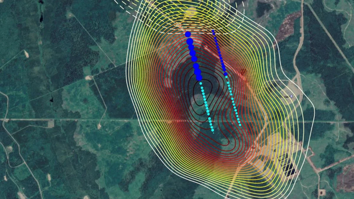
Location of modeled slip; contours show slip (2017 event—solid lines; 2018 event—dashed lines). Hydraulic fracturing stages are shown as circles, scaled to volume injected (cyan = 2017, blue = 2018). Credit: Eyre, T.S., Samsonov, S., Feng, W. et al. InSAR data reveal that the largest hydraulic fracturing-induced earthquake in Canada, to date, is a slow-slip event. Sci Rep 12, 2043 (2022)
The findings were published in Geophysical Research Letters on September 2, 2026, by Mirko van der Baan of the University of Alberta and colleagues from the University of Alberta, Natural Resources Canada, the University of Calgary, and other institutions. The study expands two previously reported slow-slip episodes in the Montney region into a sequence of 12 events distributed along the subsurface deformation limit, or wedge toe, of the Northern Rocky Mountain Fold and Thrust Belt.
Slow-slip events differ fundamentally from ordinary earthquakes. Earthquake rupture develops over milliseconds to seconds, while aseismic slip unfolds over days to weeks, allowing a fault to release substantial seismic moment without producing comparable seismic radiation or felt ground shaking. Intraplate slow-slip events are significantly rarer than slow slip observed near tectonic plate boundaries, making the northeast British Columbia sequence unusual in both setting and scale.
The researchers used interferometric synthetic aperture radar, or InSAR, which measures changes in satellite-to-ground distance between successive radar passes with sub-centimeter accuracy.

Geological cross-sections of the Rocky Mountain Fold and Thrust Belt show an internal tectonic wedge bounded by roof and floor detachments. Seismic-reflection data and the interpreted profile indicate slow slip along the near-horizontal roof thrust, while induced earthquakes occur on inclined thrust faults below. Credit: van der Baan et al. (2026), Geophysical Research Letters. Panel 1a was adapted from Hayes et al. (2021); panels 1b and 1c were adapted from Riazi and Eaton (2020). Credit: van der Baan, M., Samsonov, S., Vasyura-Bathke, H., Pradisti, R., Eaton, D. W., & Han, H. (2026). Fluid injection triggers large-scale slow-slip activation of the Rocky Mountain Fold and Thrust Belt.

Map of northeastern British Columbia showing 12 detected slow-slip events, induced earthquakes, hydraulic-fracturing treatments and active saltwater-disposal wells from 2017 to 2023. The accompanying graph shows that the resolved slow-slip events released far more cumulative seismic moment than the region’s recorded earthquakes. Credit: van der Baan, M., Samsonov, S., Vasyura-Bathke, H., Pradisti, R., Eaton, D. W., & Han, H. (2026). Fluid injection triggers large-scale slow-slip activation of the Rocky Mountain Fold and Thrust Belt.

Satellite InSAR maps show line-of-sight ground displacement associated with 12 slow-slip events detected in northeastern British Columbia between 2017 and 2023. Every event occurred near hydraulic-fracturing operations, while only some were accompanied by induced earthquakes of local magnitude 1.5 or greater. Credit: van der Baan, M., Samsonov, S., Vasyura-Bathke, H., Pradisti, R., Eaton, D. W., & Han, H. (2026). Fluid injection triggers large-scale slow-slip activation of the Rocky Mountain Fold and Thrust Belt.

Map and cross-section showing the bottom-hole depths of hydraulically fractured wells targeting the Montney Formation. Estimated slow-slip events occurred at depths of 1,640–2,410 m (5,380–7,910 feet), closely matching the depths of nearby wells and reported casing deformation. Credit: van der Baan et al. (2026), Geophysical Research Letters. Credit: van der Baan et al. (2026), Geophysical Research Letters. Panel 1a was adapted from Hayes et al. (2021); panels 1b and 1c were adapted from Riazi and Eaton (2020). Credit: van der Baan, M., Samsonov, S., Vasyura-Bathke, H., Pradisti, R., Eaton, D. W., & Han, H. (2026). Fluid injection triggers large-scale slow-slip activation of the Rocky Mountain Fold and Thrust Belt
Sentinel-1 interferograms processed over an area approximately 200 × 300 km (124 × 186 miles) revealed the 12 events within a roughly 90 × 60 km (56 × 37 miles) subregion. Only 12-day interferograms were used because vegetation caused rapid loss of radar coherence, and the events were identified through manual inspection for adjacent positive and negative displacement lobes characteristic of subsurface shear.
Bayesian source inversion resolved fault geometry for nine of the 12 events. Their equivalent moment magnitudes ranged from Mw 4.71 to 5.06, with median source depths of 1 640–2 410 m (5 380–7 910 feet) and typical depth uncertainties of about ±400 m (±1 310 feet). Average modeled slip reached 10–20 cm (4–8 inches) across fault areas spanning several km2. Three events were detected in the InSAR observations but did not yield resolved source mechanisms.
The resolved sources were generally near-horizontal, with a median fault dip of 9.9°. Regional geological formations dip about 1–4°, supporting the authors’ interpretation that sustained slip occurred mainly along a bedding-parallel roof detachment within a duplex thrust system rather than on the steeper thrust faults responsible for some conventional seismic rupture in the region. Two source solutions carried substantial uncertainty in fault dip.
A duplex is a stack of thrust-bounded rock slices between detachment surfaces. The roof detachment forms the upper boundary of that structure, while the wedge toe marks the subsurface leading edge of the fold-and-thrust deformation system. The study places the slow-slip events close to this wedge toe, where tectonic stresses remain stored in faults inherited from formation of the Canadian Rocky Mountains.
BC Energy Regulator records examined in the study contained more than 1 200 hydraulic-fracturing treatments in the area from 2017 to 2023, generally at bottom-hole depths of 1 500–2 500 m (4 920–8 200 feet). The depths overlap the estimated 1 640–2 410 m (5 380–7 910 feet) slow-slip sources, and all 12 events occurred during and near hydraulic-fracturing operations.
For a single slow-slip event, the researchers calculated a 6.4% probability of occurring within a 5 × 5 km area and within one month of a hydraulic-fracturing treatment. Applying the same criterion to all 12 events produced a chance probability of about 10^-13%, which the authors considered sufficient to rule out coincidence.
Pore-pressure diffusion provides one mechanism consistent with the association. Using an effective diffusivity of 0.13 m2/s representative of the Montney Formation, the researchers calculated that a pressure perturbation would travel about 1.0 km (0.62 miles) during a one-week treatment. Increased pore pressure lowers the effective normal stress holding a critically stressed fault closed; the paper also considers static stress transfer from opening hydraulic fractures, or a combination of both processes.
Saltwater disposal cannot be excluded as a contributing factor for individual events. All but the three northern slow-slip events occurred within 5 km (3.1 miles) of active brine-disposal wells, but hydraulic fracturing remained the common factor across the entire sequence. The study also found that injected treatment volume alone did not determine whether slow slip occurred, with events associated with both relatively modest and larger treatments.
The InSAR displacement cannot be explained by the accompanying earthquakes alone. The paper calculates that an Mw 4.7 slow-slip source at 2.5 km (1.6 miles) depth would produce about 1.9 cm (0.75 inches) of maximum surface displacement, while an Mw 3.6 earthquake at comparable depth would produce approximately 1.5 mm (0.06 inches). The contrast supports the interpretation that the observed deformation originated from sustained aseismic shear rather than co-seismic displacement from the recorded earthquakes.
Approximately 2 300 ML≥1.5 earthquakes were recorded in the region between 2005 and 2023, including about 800 during the 2017–2023 InSAR observation period. Despite their much smaller number, the detected slow-slip events released cumulative seismic moment orders of magnitude greater than the earthquake population, making slow slip the dominant component of total modeled fault displacement in the comparison.
About half of the 12 slow-slip events occurred without accompanying ML≥1.5 earthquakes, and none was associated with an ML≥4 earthquake. Where slow slip and earthquakes occurred together, the authors identify stress transfer from slow movement along the roof detachment to velocity-weakening fault patches in underlying competent rock as one plausible earthquake-triggering mechanism. Because about half of the slow-slip events occurred without ML≥1.5 seismicity, that stress transfer was neither systematic nor necessary for earthquake occurrence.
 Schematic interpretation. Cross-section showing the structure of the Rocky Mountain foreland thrust belt in the region, based on. Glide planes form in weaker and/or overpressured sedimentary layers; the inferred glide plane for the SSEs is shown in magenta. HF hydraulic fracturing wells, BF Blueberry Fault, UF unnamed fault; ~ 28 × vertical exaggeration. Credit: Eyre, T.S., Samsonov, S., Feng, W. et al. InSAR data reveal that the largest hydraulic fracturing-induced earthquake in Canada, to date, is a slow-slip event. Sci Rep 12, 2043 (2022)
 Modelled slow slip events and spatiotemporal relationship to hydraulic fracturing. (A) Location of modelled slip; contours show slip (2017 event—solid lines; 2018 event—dashed lines). Hydraulic fracturing stages are shown as circles, scaled to volume injected (cyan = 2017, blue = 2018). Strike, dip, slip vector and SHmax are labelled. (B) Cumulative fluid volume injected for the Middle and Lower Montney wells and InSAR data acquisition times (black circles) for 2017 (L) and 2018 (R) spanning periods of measurable deformation used to help constrain SSE timing. Credit: Eyre, T.S., Samsonov, S., Feng, W. et al. InSAR data reveal that the largest hydraulic fracturing-induced earthquake in Canada, to date, is a slow-slip event. Sci Rep 12, 2043 (2022)
 Seismicity in the region recorded on the regional network. (a) Map of events during the period 2014–2021 colored by time and scaled by magnitude. No major events were recorded, including during the slip episodes in 2017 and 2018. Horizontal wells are shown in red. (b) Seismicity over the time period 2017–2020 plotted versus distance to the wellpad and scaled by magnitude. Times shaded in grey correspond to the approximate times at which the SSEs occurred; there appears to be no spatiotemporal correlation with significant seismic events. Credit: Eyre, T.S., Samsonov, S., Feng, W. et al. InSAR data reveal that the largest hydraulic fracturing-induced earthquake in Canada, to date, is a slow-slip event. Sci Rep 12, 2043 (2022)


Equivalent moment magnitude does not imply equivalent shaking. The largest event, Mw 5.06, was modeled with a duration of roughly 1–10 days, compared with about 3 seconds for an earthquake of similar magnitude. Its moment rate was therefore five to six orders of magnitude smaller, accounting for the absence of felt shaking despite the large total seismic moment.
Subsurface infrastructure showed the clearest documented operational effect. BC Energy Regulator records showed casing deformation during all but four coincident hydraulic-fracturing treatments. The study describes the deformation as bending or shearing of thick-walled steel casing cemented inside the wells, while the modeled 10–20 cm (4–8 inches) average fault slip is comparable to well diameters.
The authors assess risk to surface infrastructure from the detected slow slip as limited but identify a hazard and economic risk for underground infrastructure, including hydrocarbon boreholes. They describe the scale of the sequence — 12 InSAR-detectable events distributed over more than 100 km (62 miles), with resolved equivalent magnitudes reaching Mw 5.06 — as, to their knowledge, unprecedented among other shale plays.
Two of the events had been reported previously in a 2022 Scientific Reports study by Thomas S. Eyre and colleagues. The 2026 analysis incorporates those cases and adds 10 detected slow-slip events, changing the observational picture from two localized episodes to a multi-year sequence extending along the regional fold-and-thrust system.
The geological interpretation extends beyond the modern injection operations. Van der Baan and colleagues propose that the roof detachment near the wedge toe may have advanced episodically through slow slip during development of the Rocky Mountain Fold and Thrust Belt, with modern fluid injection reactivating faults that retain stored tectonic stress. That interpretation concerns the fault system’s geological history and remains an interpretation derived from the observed modern deformation rather than a directly observed ancient process.
Induced seismicity was already regulated in northeast British Columbia before publication of the new paper. The BC Energy Regulator strengthened its Kiskatinaw requirements in February 2025 and established a North Montney monitoring and mitigation area. The Kiskatinaw order requires hydraulic-fracturing operations to suspend following an ML3.00 or greater event, while the North Montney threshold is ML4.00 or greater, alongside pre-assessment and real-time seismic monitoring requirements.
The slow-slip observations do not carry the same short-term hazard implications as earthquakes of equivalent moment magnitude. The authors conclude that release of stored tectonic energy through the detected events has so far had little-to-no impact on short-term earthquake hazard models, while casing deformation shows that slow slip can pose a direct hazard to underground infrastructure.
References:
1 Mirko van der Baan, M., Samsonov, S., Vasyura-Bathke, H., Pradisti, R., Eaton, D. W., & Han, H. (2026). Fluid injection triggers large-scale slow-slip activation of the Rocky Mountain Fold and Thrust Belt. Geophysical Research Letters, 53, e2026GL122295. https://doi.org/10.1029/2026GL122295
2 Eyre, T. S., Samsonov, S., Feng, W., Kao, H., & Eaton, D. W. (2022). InSAR data reveal that the largest hydraulic fracturing-induced earthquake in Canada, to date, is a slow-slip event. Scientific Reports, 12, 2043. https://doi.org/10.1038/s41598-022-06129-3

I’m a science journalist and researcher at The Watchers, contributing to the Epicenter edition, where I cover peer-reviewed scientific research and emerging discoveries across Earth and space sciences. With a background in astronomy and a passion for environmental science, I’ve worked in shark and coral conservation in Fiji, conducting reef and shark-behavior research, contributing to mangrove restoration, and earning PADI Open Water and Coral Reef Certifications. I bring a blend of scientific rigor and storytelling to illuminate the discoveries shaping our planet and beyond.

Commenting rules and guidelines
We value the thoughts and opinions of our readers and welcome healthy discussions on our website. In order to maintain a respectful and positive community, we ask that all commenters follow these rules.