
Alaska megatsunami ranks second highest ever recorded
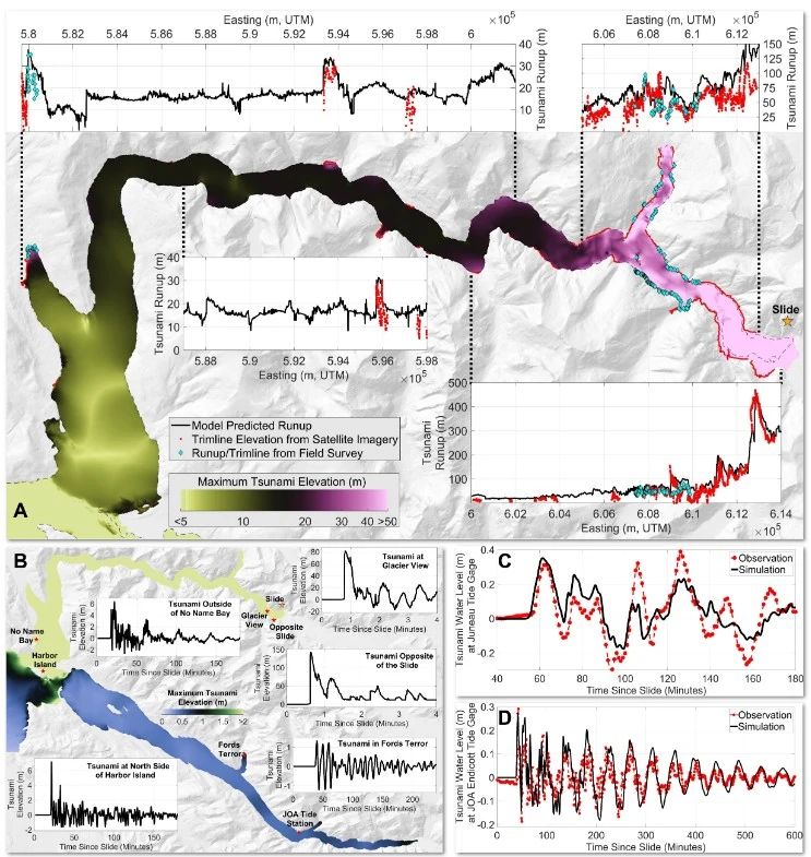
A landslide-generated tsunami in Tracy Arm, Alaska, reached 481 m (1 578 feet) on August 10, 2025, ranking as the second-highest tsunami runup ever recorded, according to a study published in Science on May 6, 2026. More than 64 million m³ (2.3 billion ft³) of rock collapsed near South Sawyer Glacier.
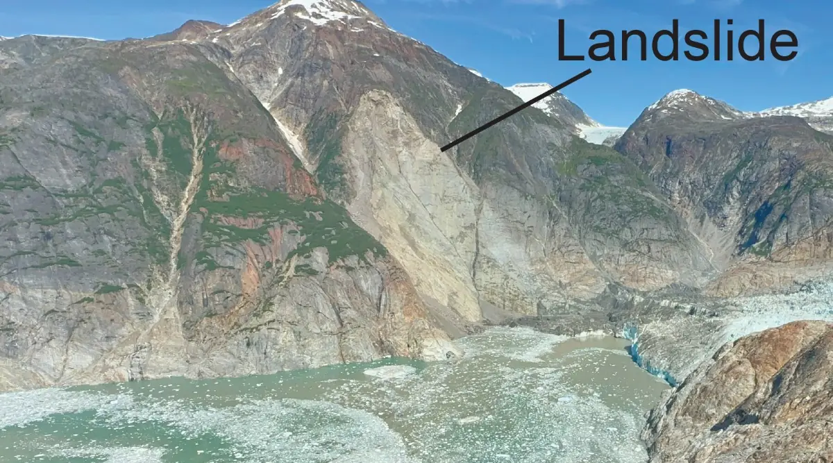
Oblique aerial view of the August 10, 2025 landslide scar above South Sawyer Glacier in Tracy Arm, Alaska. The landslide generated a tsunami runup of 481 m (1 578 feet). Credit: USGS/John Lyons
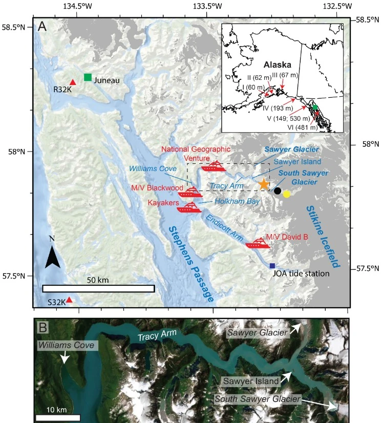
The landslide occurred at 05:26 AKDT (13:26 UTC) in Tracy Arm, southeast of Juneau, after a large section of unstable mountainside failed above the toe of South Sawyer Glacier and plunged into the fjord, according to the U.S. Geological Survey (USGS).
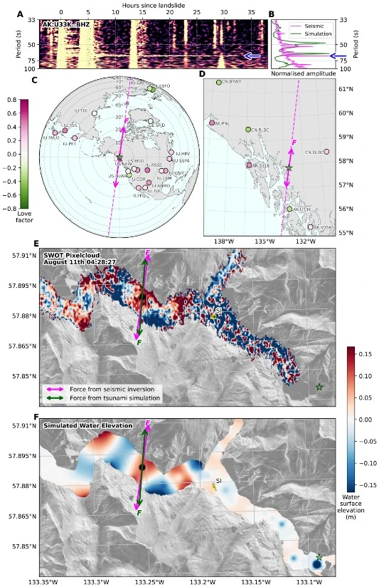
The landslide was preceded by several days of microseismicity, which increased in rate and magnitude until about 1 hour before failure. It produced globally observed long-period seismic waves equivalent in size to a M5.4 earthquake.
The impact displaced a massive volume of water and generated a localized tsunami that stripped vegetation from steep fjord walls and left high-water marks hundreds of meters above sea level.
Researchers reconstructed the event using field observations, seismic records, satellite imagery, and topographic analysis. Their findings placed the Tracy Arm tsunami behind only the 1958 Lituya Bay event in Alaska, where a landslide-triggered wave reached about 524 m (1 720 feet).
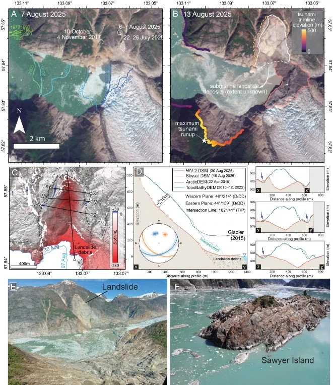
The Alaska Earthquake Center reported that no earthquake was detected near the landslide site. Seismic instruments instead recorded signals consistent with a large rockslide entering the fjord. The center also received reports of tsunami waves measuring 3-4.6 m (10-15 feet) near Harbor Island and at least 30 m (100 feet) at Sawyer Island.
Eyewitness accounts collected by the researchers showed that the tsunami propagated far beyond the immediate landslide area and produced strong surges and hazardous currents throughout Tracy and Endicott arms. Observations documented in the study came from kayakers, small vessels, and a cruise ship located tens of kilometers from the collapse site at the time of the event.
A group of kayakers camped on Harbor Island, about 55 km (34 miles) from the landslide, reported waking at 05:45 AKDT (13:45 UTC), about 20 minutes after the collapse, to water flowing through their campsite. According to the study, one kayak and much of their equipment were swept away as the surge moved across the island.
Additional observations came from No Name Bay, about 50 km (31 miles) from the landslide, where a witness aboard the motor vessel Blackwood described a cresting wave 2-2.5 m (6-8 feet) high moving along the shoreline from the direction of Tracy Arm. The observer reported that the initial wave was followed by another surge about 1 m (3-4 feet) high.
Researchers also documented prolonged water surges in Endicott Arm, where the small cruise vessel David B was anchored in Fords Terror about 85 km (53 miles) from the landslide. Crew members described water pouring across a nearby sandbar and reported the vessel rising about 3 m (10 feet) despite an outgoing tide. According to the study, surging continued for several hours after the collapse.
At about 11:00 AKDT (19:00 UTC), roughly 5.5 hours after the landslide, the crew found that a skiff anchored near shore had been left stranded on dry land within minutes as water levels rapidly changed.
The expedition cruise ship National Geographic Venture, carrying about 150 people, was anchored near the mouth of Tracy Arm when the tsunami occurred. The vessel’s captain reported strong currents and white water near the fjord margins, but no clearly defined wave at the ship’s location. Dense fog limited visibility inside the fjord, although large amounts of floating ice and debris were visible in the water.
The study linked the collapse to slope destabilization in a rapidly changing glacial environment. Researchers reported that the retreat of South Sawyer Glacier had reduced support at the base of the slope before failure occurred.
Tracy Arm is a seasonal cruise destination in Southeast Alaska. Associated Press reported in April 2026 that several cruise operators had stopped sending vessels into the fjord because of continuing concerns over slope instability and localized tsunami hazards.
The event drew renewed attention to landslide-tsunami hazards in glacier-fed fjords, particularly in steep coastal terrain undergoing rapid ice retreat. Researchers and hazard specialists have increasingly monitored such environments in Alaska and Greenland following several large recent collapses.
References:
1 Shugar, D. H., Barnhart, K. R., Berdahl, M., Caplan-Auerbach, J., Ekström, G., Fathian, A., Geertsema, M., Hicks, S. P., Higman, B., Jensen, E. K., Karasözen, E., Lynett, P., Lyons, J., Monahan, T., Roe, G., Svennevig, K., Toney, L., Van Wyk de Vries, M., & West, M. E. (2026). A 481-meter-high landslide-tsunami in a cruise ship–frequented Alaska fjord. Science. Advance online publication. https://doi.org/10.1126/science.aec3187
I'm a dedicated researcher, journalist, and editor at The Watchers. With over 20 years of experience in the media industry, I specialize in hard science news, focusing on extreme weather, seismic and volcanic activity, space weather, and astronomy, including near-Earth objects and planetary defense strategies. You can reach me at teo /at/ watchers.news.
Commenting rules and guidelines
We value the thoughts and opinions of our readers and welcome healthy discussions on our website. In order to maintain a respectful and positive community, we ask that all commenters follow these rules.