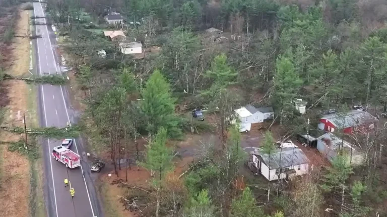
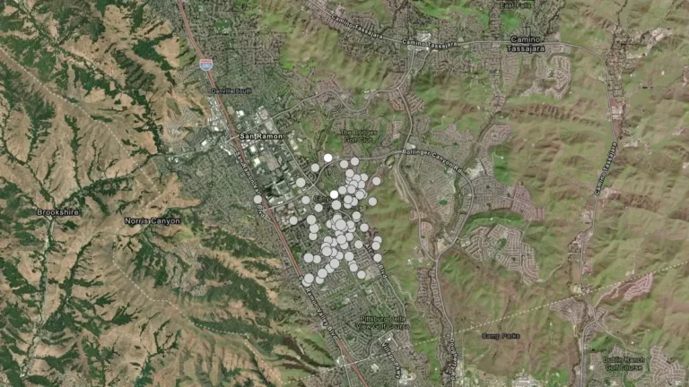
• Severe Tropical Cyclone Narelle forecast to briefly reach Category 5 before Queensland landfall, Australia

    Severe Tropical Cyclone Narelle is forecast to intensify to Category 5 peak intensity over the Coral Sea before approaching the Far North Queensland coast between Lockhart River and Cooktown on March 20, 2026. Destructive winds of over 250 km/h (155 mph), along with rainfall totals over 350 mm (14 inches), are expected to triggere flash flooding, significant storm surges, and coastal flooding.

  • Historic March blizzard buries parts of Michigan’s Upper Peninsula under up to 132 cm (52 inches) of snow

    A late-season blizzard affected northern Michigan between March 15 and 17, 2026, dropping up to 132.1 cm (52 inches) of snow in parts of the Upper Peninsula and breaking snowfall records at the National Weather Service office in Marquette. Governor Gretchen Whitmer declared a state of emergency on March 17 for seven counties in the Upper Peninsula and northern Lower Peninsula as heavy snow, ice, and strong winds disrupted travel and power service.

  • El Niño forecast in 2026 as La Niña weakens and Pacific subsurface heat increases

    La Niña conditions persisted across the equatorial Pacific Ocean during February 2026, but forecasters expect the pattern to transition to ENSO-neutral within the next month. The Climate Prediction Center said on March 12, 2026, that El Niño is likely to emerge during June–August 2026 with a probability of 62% and could persist through at least the end of the year.

  • Magma accumulation beneath Svartsengi now largest since eruption sequence began, Iceland

    More than 23 million m³ (812 million feet³) of magma have accumulated beneath the Svartsengi volcanic system on Iceland’s Reykjanes Peninsula since the July 2025 eruption. Monitoring data released March 17, 2026, by the Icelandic Meteorological Office show this is the largest magma accumulation between eruptions since activity began on the Sundhnúksgígar crater row in December 2023. The official hazard assessment for the area remains unchanged and is valid until March 31.

  • Spain sees wettest January–February in 47 years as Atlantic storms soak Iberian Peninsula

    Spain experienced an exceptionally wet winter between December 2025 and February 2026 as repeated Atlantic storms brought prolonged rainfall across the Iberian Peninsula. AEMET reported 323.2 mm (12.7 inches) of precipitation across peninsular Spain, equal to 171% of the 1991–2020 average, making it the country’s eighth wettest winter since 1961 and third wettest of the 21st century.

  • Prolonged atmospheric river brings Flood Watch and high avalanche danger to British Columbia as some areas face up to 400 mm (15.7 inches) of rain

    A prolonged atmospheric river is affecting British Columbia this week, with Flood Watch, multiple rainfall warnings, and Special Weather Statements in effect across parts of the province. Some coastal areas could receive up to 400 mm (15.7 inches) of rain, while heavy rain on existing snowpack is increasing the risk of flooding, washouts, landslides and dangerous avalanche conditions.

  • Atmospheric river forecast to stall over Washington, raising flood risk through March 20

    A stalled atmospheric river over the Pacific Northwest is forecast to deliver 127–254 mm (5–10 inches) of precipitation to parts of Washington between March 17 and 20, 2026. High freezing levels above 2 100 m (7 000 feet) will result in rainfall across most elevations, accelerating snowmelt and increasing the likelihood of riverine flooding.

  • Tropical Cyclone Narelle forms in Coral Sea, forecast to intensify before Queensland impact, Australia

    ropical Cyclone Narelle developed in the northern Coral Sea on Tuesday, March 17, 2026, with sustained winds of 85 km/h (53 mph) and gusts to 120 km/h (75 mph). The system is moving west-southwest toward Far North Queensland and is forecast to intensify to severe tropical cyclone strength before approaching the coast later this week, with damaging winds, heavy rainfall, and coastal flooding being forecast.

  • Dust storm triggers multi-vehicle crash on U.S. 287 in northern Texas

    A multi-vehicle crash occurred on U.S. Highway 287 near Quanah in Hardeman County, northern Texas, on March 15, after strong winds generated blowing dust that rapidly reduced visibility and created dangerous driving conditions. Video footage recorded in the area shows dense dust moving across the highway as vehicles traveled through the corridor. Visibility deteriorated rapidly…