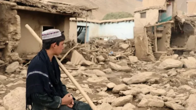
• More than 300 mm (11.8 inches) of rain triggers flooding, evacuations, and dam overflow in South Africa

    More than 301 mm (11.9 inches) of rain fell in parts of South Africa’s Garden Route after an intense cut-off low brought flooding, evacuations, road closures, and infrastructure damage across the Western and Eastern Cape from May 5–7, 2026. At least one person died in Knysna, hundreds were affected in Garden Route shelter operations, and emergency shelters were opened across flood-affected parts of Nelson Mandela Bay and the Eastern Cape.

  • Tornado Emergency issued as large tornado hits Brookhaven area, Mississippi

    A large, destructive tornado moved through the Brookhaven area of southern Mississippi during the evening of May 6, 2026, after the National Weather Service in Jackson issued a Tornado Emergency for communities including Brookhaven and Bogue Chitto. The event developed within an SPC Enhanced Risk severe weather setup and produced repeated radar-confirmed Tornado Debris Signatures as the storm moved from Franklin County into Lincoln County and toward Lawrence County.

  • Multiple tornadoes reported in southeastern Türkiye during deadly severe weather outbreak

    The European Severe Weather Database (ESWD) listed multiple tornado reports across southeastern Türkiye on May 3, 2026, during a severe storm episode that caused casualties, injuries, widespread damage, power disruption, and localized flooding. The Şanlıurfa Governorate confirmed 1 death and 40 injuries in Birecik and Viranşehir during the outbreak, while a later report quoted Governor Hasan Şıldak as saying the death toll had risen to 2.

  • Enhanced Risk of severe thunderstorms from Louisiana through Mississippi into Alabama on May 6

    An Enhanced Risk (Level 3/5) of severe thunderstorms has been issued for parts of the Lower Mississippi Valley on May 6, 2026, as forecasters warned that storms capable of producing damaging winds, large hail, and tornadoes are expected to develop from the Southern Plains into the Southeast. Heavy rainfall rates of 25 to 50 mm (1 to 2 inches) per hour may also accompany stronger storms across the region.

  • Heavy, wet May snow disrupts Colorado’s Front Range

    A heavy, wet late-season snowstorm affected Colorado’s Front Range, foothills, mountains, and I-25 urban corridor from Tuesday, May 5, into Wednesday, May 6, 2026, closing schools, prompting travel advisories and shelter activation, delaying flights at Denver International Airport, and causing scattered power outages. NWS Denver/Boulder forecast 13-20 cm (5-8 inches) along the I-25 corridor, with local totals up to 30 cm (12 inches) near the foothills and Palmer Divide. Heavier mountain snow was also forecast along and north of I-70, where CDOT warned of hazardous travel conditions.

  • Kīlauea episode 46 ends after 9 hours of lava fountaining, tephra reaches Highway 11, Hawaii

    Episode 46 of the ongoing Halemaʻumaʻu eruption at Kīlauea ended at 17:22 HST on May 5, 2026 (03:22 UTC on May 6), after about 9 hours of continuous lava fountaining from the north vent at the summit. USGS lowered the Volcano Alert Level from Watch to Advisory and the Aviation Color Code from Orange to Yellow after ground and aviation hazards decreased.

  • Lava flow from Stromboli’s North crater reaches coastline, Italy

    Lava overflow activity increased at Stromboli from 21:20 LT (19:20 UTC) on May 4, 2026, sending a flow from the North crater area down the Sciara del Fuoco to the coastline by about 03:00 LT (01:00 UTC) on May 5. INGV reported average volcanic tremor, a slight increase in explosion-related earthquakes, and no significant GNSS change.