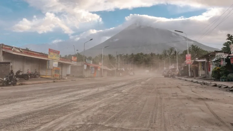
I'm a dedicated researcher, journalist, and editor at The Watchers. With over 20 years of experience in the media industry, I specialize in hard science news, focusing on extreme weather, seismic and volcanic activity, space weather, and astronomy, including near-Earth objects and planetary defense strategies. You can reach me at teo /at/ watchers.news.

  • Red wind warning and widespread severe weather alerts issued as Cyclone Vaianu approaches North Island, New Zealand

    Cyclone Vaianu is forecast to move south across New Zealand’s North Island on Sunday, April 12, 2026, bringing a multi-hazard threat, including damaging winds up to 140 km/h (87 mph), heavy rainfall, and coastal inundation risk. A Red Strong Wind Warning is in force for the Coromandel Peninsula and Great Barrier Island, with widespread Orange warnings and watches covering much of the North Island and upper South Island. Significant disruption to transport, power supply, and communities is expected.

  • Tropical Storm Sinlaku strengthens, rapid intensification forecast as it tracks toward Guam

    Tropical Storm Sinlaku formed on April 9, 2026, in the western Pacific and strengthened to 102 km/h (63 mph) by 15:00 UTC on April 10, approximately 904 km (562 miles) southeast of Andersen Air Force Base, Guam. The system is becoming more organized and is forecast to undergo rapid intensification while tracking toward the Mariana Islands, with a potentially dangerous passage near or over Guam.

  • Tephra up to 25 cm (10 inches) reported in the Volcano Golf Course subdivision during Kīlauea eruption episode 44, Hawaiʻi

    Tephra up to 25 cm (10 inches) was reported in the Volcano Golf Course subdivision near Kīlauea, Hawaiʻi, during episode 44 of the ongoing summit eruption, which ended at 05:41 UTC on April 10, 2026, after 8 hours and 31 minutes of lava fountaining. The eruption generated 5.8 million m³ (7.5 million cubic yards) of lava, while ash and Pele’s hair reached as far as Hilo, prompting warnings and temporary closures.

  • Large landslide reactivation blocks A14 motorway and Adriatic rail line in Molise, Italy

    A large landslide reactivated in Petacciato, Campobasso Province, Italy, on April 7, 2026, after more than 200 mm (7.9 inches) of rainfall within a few days, blocking a 4 km (2.5 miles) section of the A14 motorway and the Adriatic railway line and forcing precautionary evacuations. Approximately 50 people were evacuated as authorities activated emergency response measures and rerouted traffic across the region.

  • Daylight fireball seen from New Jersey, New York, and Pennsylvania

    A daylight fireball was observed across multiple northeastern U.S. states at 18:34 UTC on April 7, 2026, producing 260 eyewitness reports and multiple videos and photographs. The object entered the atmosphere above the Atlantic Ocean and disintegrated over New Jersey after traveling more than 180 km (112 miles).

  • Tropical Cyclone Vaianu expected to bring damaging winds and heavy rain to New Zealand this weekend

    Severe Tropical Cyclone Vaianu was located south of Fiji on April 8, 2026, producing localized flooding while weakening under strong wind shear. The system is forecast to transition into an extra-tropical system before moving toward New Zealand, where damaging winds, heavy rain, and hazardous coastal conditions are expected during the weekend of April 11-12.

  • Severe Tropical Cyclone Maila tracks toward Papua New Guinea and Queensland, Australia

    Severe Tropical Cyclone Maila remained over the Solomon Sea at 06:00 UTC on April 8, 2026, with sustained winds of 165 km/h (103 mph) and a central pressure of 941 hPa, while beginning a gradual weakening trend after recent rapid intensification. The system is moving slowly northward at 6 km/h (3.7 mph) and is forecast to track west to southwest toward southeastern Papua New Guinea before entering the Coral Sea later this week.

  • Flood Watch issued across Hawaii as kona low system brings risk of heavy rain and flood

    The National Weather Service has issued a Flood Watch for all Hawaiian islands as a developing low-pressure system, described as a kona low, brings increasing moisture and instability to the region from Wednesday, April 8, through Friday, April 10, 2026. Excessive rainfall may lead to flash flooding, runoff impacts, and landslides across all major islands.