
Hurricane Nolo forecast to cross International Date Line into western North Pacific, transitioning into a typhoon
Hurricane Nolo was forecast to cross 180° longitude on October 4, 2026, and enter the western North Pacific at typhoon strength. At 23:00 HST on October 3 (09:00 UTC on October 4), the National Hurricane Center (NHC) placed Nolo 390 km (240 miles) southwest of Lisianski Island with maximum sustained winds of 175 km/h (110 mph).

Nolo’s center was located about 655 km (405 miles) west-southwest of Maro Reef. The cyclone was moving west at 30 km/h (18 mph), with an estimated minimum central pressure of 963 hPa.
Hurricane-force winds extended as far as 55 km (35 miles) from the center, while tropical-storm-force winds extended up to 240 km (150 miles).
NHC forecast Nolo near 24.0°N, 179.2°W at 18:00 UTC on October 4, with maximum sustained winds of 195 km/h (120 mph). The forecast placed the cyclone west of 180° near 24.8°N, 177.6°E at 06:00 UTC on October 5, with winds of 205 km/h (125 mph), followed by a peak near 215 km/h (130 mph) at 18:00 UTC that day.
No coastal watches or warnings were in effect at 09:00 UTC on October 4. Large swells associated with Nolo were affecting Papahānaumokuākea Marine National Monument, and NHC said surf would likely inundate some low-lying atolls from Maro Reef to Lisianski Island during the following several days.
For tropical-cyclone monitoring, 180° longitude separates the central North Pacific from the western North Pacific. A tropical cyclone with maximum sustained winds of at least 119 km/h (74 mph) is termed a hurricane in the central North Pacific and a typhoon in the western North Pacific.
Nolo will remain the same physical cyclone and retain its name after crossing the basin boundary. Regional advisory responsibility will shift from the Central Pacific Hurricane Center/NHC to the Japan Meteorological Agency’s Regional Specialized Meteorological Center in Tokyo. Official wind estimates issued before and after the crossing may differ because NHC and JMA use different sustained-wind averaging periods.
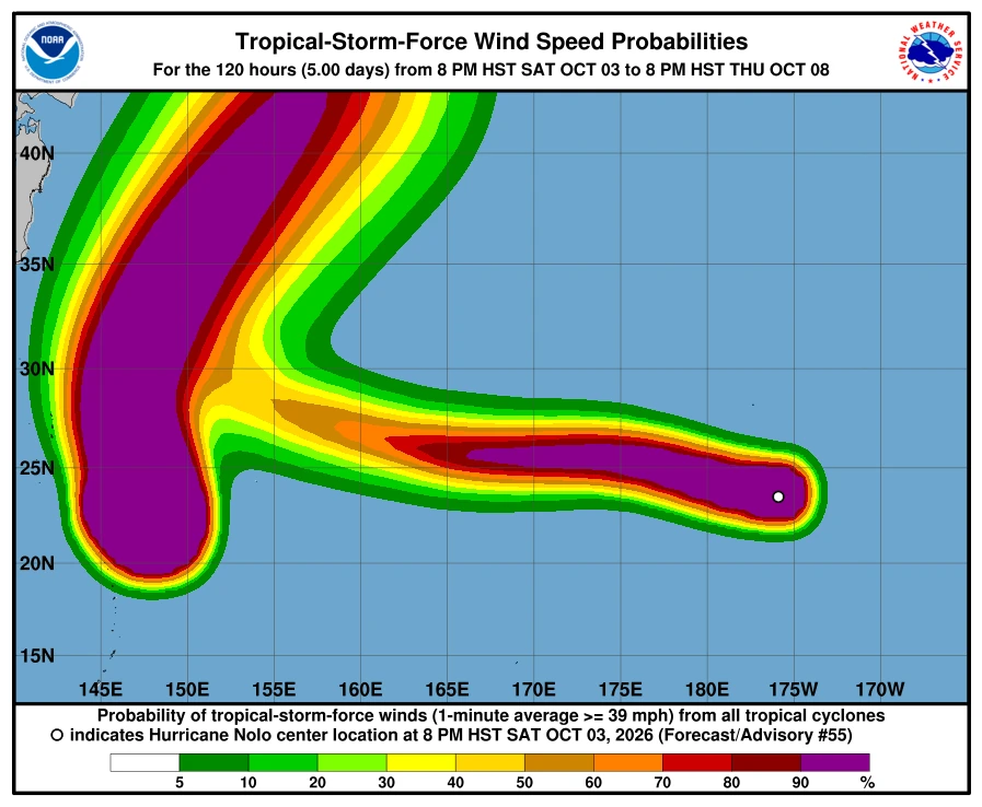
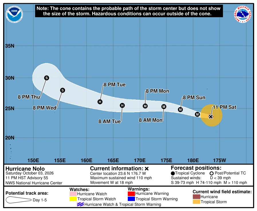
How rare are hurricane crossings of the Date Line?
East-to-west Date Line crossings by organized tropical cyclones occur only once every few years, while crossings at hurricane strength are less common.
NOAA’s HURDAT2 and International Best Track Archive for Climate Stewardship (IBTrACS) records identified 27 completed crossings at U.S. tropical-storm strength or higher from 1949 through 2025: 15 at tropical-storm strength and 12 at hurricane strength.
The hurricane-strength cases were Della in 1957, Patsy in 1959, Peke in 1987, Uleki in 1988, Keoni in 1993, John in 1994, Ele and Huko in 2002, Ioke in 2006, Genevieve in 2014, Kilo in 2015 and Dora in 2023.
If Nolo crosses 180° with one-minute sustained winds of at least 119 km/h (74 mph), it would become the 28th tropical-storm-or-stronger crossover and the 13th hurricane-strength crossover in that record.
The analysis counts each cyclone once and estimates its intensity at 180° from adjoining best-track points. It excludes systems that crossed only as tropical depressions, subtropical or post-tropical cyclones, disturbances or remnant lows; totals based on JMA data can differ because JMA uses 10-minute sustained winds, while NHC uses one-minute winds, and some early records lack comparable intensity estimates.
Nolo’s inner core was reorganizing as an eyewall replacement cycle progressed. Satellite imagery showed that the small eye observed earlier had largely decayed while convection formed a broader ring, and microwave imagery at 05:49 UTC on October 4 indicated that the outer eyewall was consolidating after the inner eyewall was no longer visible.
NHC expected renewed strengthening if the eyewall replacement cycle completed cleanly. Nolo was moving over sea-surface temperatures of 28–29°C (82–84°F) in an environment with vertical wind shear near 9 km/h (6 mph), equivalent to 5 kt.
The agency forecast substantial weakening between October 6 and 7 as northeasterly wind shear increased and drew very dry mid-level air into the cyclone’s core. NHC attributed the expected change to an amplified upper-level pattern associated with recurving Typhoon Choi-Wan.
References
1 Hurricane Nolo Advisory Number 55 – NOAA/NHC – October 4, 2026
2 Hurricane Nolo Forecast Advisory Number 55 – NOAA/NHC – October 4, 2026

Rishav Kothari is Editor-in-Chief of The Watchers, where he runs the newsroom and covers earthquakes, volcanoes, severe weather and space weather.
Published in the last 24 hours
- Second nationwide US flight halt since 9/11: how the November 13 FAA ground stop compares with September 2001 and January 2023 Epicenter
- FAA grounds all departing flights across the US after communications outage hits air traffic control centers nationwide
- In September 1859, a solar storm lit up the night sky so brightly that gold miners in the Rocky Mountains woke up after midnight and started cooking breakfast, convinced the aurora glowing over their camp was the sunrise Epicenter
- A patch of warm Pacific water that could become the strongest El Niño in more than 70 years sits thousands of miles from any American town, yet it is already the main reason NOAA expects a wetter winter across the South and a milder one across the North
