
Satellite data show a graben-like formation that cuts through part of Grindavík, Iceland
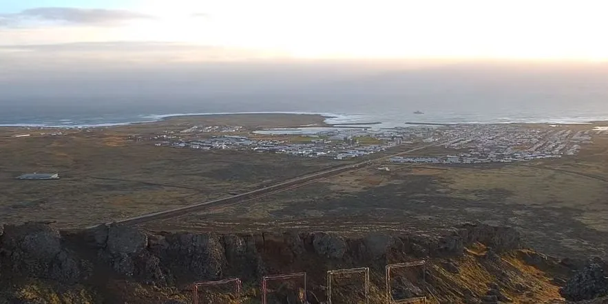
Image credit: Live From Iceland (stillshot)
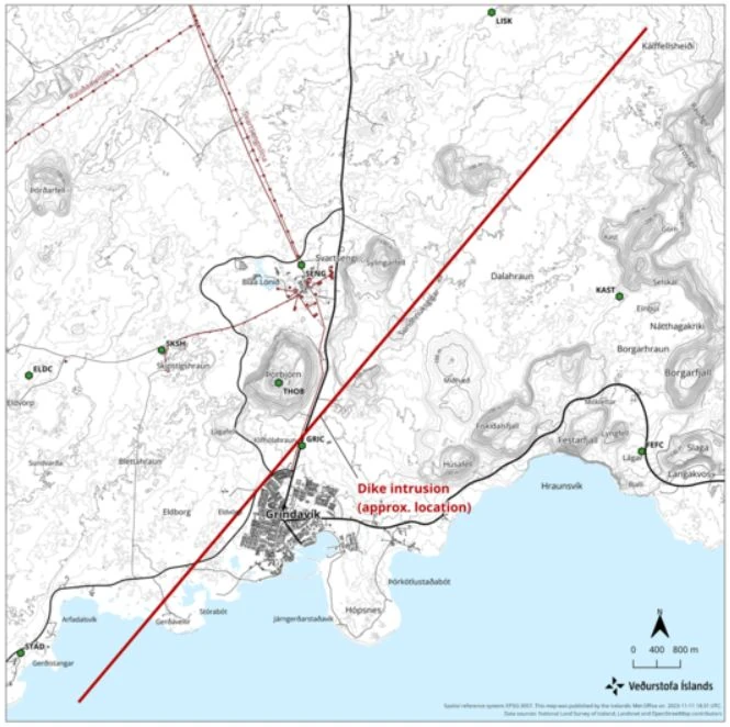
Seismicity along the 15-km (9.3 miles) long magma intrusion in Iceland continues, although the size and intensity of the activity is decreasing, the Icelandic Met Office reported at 13:00 UTC on November 13, 2023
Since midnight UTC today, around 900 earthquakes have been detected. The seismic activity is concentrated on the region of the intrusion, between Sundhnúkur and Grindavík at a depth of about 2 – 5 km (1.2 – 3.1 miles).
While decreasing rates of ground deformation are seen in GPS data from Grindavík, satellite radar results show a graben-like formation that cuts through part of Grindavík. This feature was first identified by IMO in satellite radar imagery early on November 12.
The imagery shows up to 1 m (3.3 feet) of vertical ground displacement in the western part of Grindavík, caused by the propagation of the magma intrusion. “From geodetical modeling results, we infer that (as of November 12) the greatest area of magma upwelling is sourced close to Sundhnúkur, 3.5 km (2.1 miles) north-northeast of Grindavík,” IMO scientists said.
According to their latest estimates, the volcanic hazard assessment in and around Grindavík is unchanged from November 12. All monitoring systems are being monitored closely in real-time, especially near Grindavík, for any indications of sudden change.
The natural hazards monitoring team at IMO is operating at maximum surveillance while the Department of Civil Protection and Emergency Management coordinates short-term, temporary access to Grindavík today, November 13.
Key takeaways from our previous reports about seismo-volcanic activity near Grindavik, Reykjanes peninsula:
- Initial seismic activity detection: The earthquake swarm started on October 25, 2023. The onset of an intense seismic swarm north of Grindavík was first observed at 15:00 UTC on November 10.
- Major earthquake event: The largest earthquake in this swarm, with a magnitude of 5.0, occurred at 18:00 UTC on October 10, located 1 km (0.6 miles) east of Mt. Þorbjörn.
- Dike intrusion confirmation: GPS and satellite imagery subsequently confirmed a dike intrusion extending from Sundhnjúkagig through Grindavík and southwestward.
- Observation of unprecedented ground deformation: Data revealed that the rate of ground deformation in the area is significantly higher than any previously recorded levels on the Reykjanes Peninsula.
- Magma accumulation analysis: It was noted that the volume of magma accumulated has now surpassed that of the previous three eruptions in the area.
- Extent of magma intrusion: Further data analysis indicated that the magma intrusion extends from Stóra-Skógsfell in the north to Grindavík in the south, extending beneath the sea.
- Magma intrusion depth determination: The shallowest depth of the magma intrusion north of Grindavík was identified as 800 m (2 600 feet).
- Magma movement detection: Instruments showed clear signs of magma moving toward the surface.
- Comprehensive hazard assessment: At a status meeting held at 18:00 UTC today, a 15-km (9.3 miles) long dike intrusion was identified just northwest of Grindavík, representing a significant volcanic hazard.
- Emergency response initiation: In response to these findings, the Civil Defense declared a state of emergency on November 10 and ordered the evacuation of Grindavík, with a population of 2 856, to mitigate potential risks.
References:
1 Significant likelihood of a volcanic eruption in the coming days – IMO – Update released at 13:00 UTC on November 13, 2023
2 High risk of eruption near Grindavík: 15-km long magma intrusion identified northwest of town, Iceland – The Watchers – November 11, 2023
3 Emergency declared as record-high magma accumulation and intense earthquake swarm force Grindavík evacuation, Iceland – The Watchers – November 11, 2023
The Watchers team and our contributors bring the latest on extreme weather, earthquakes, volcanic eruptions, space weather, and all things science. We're all about making sense of the natural world and keeping you informed on what’s happening. Got a tip or a question? Hit us up using the form at newstips!
Commenting rules and guidelines
We value the thoughts and opinions of our readers and welcome healthy discussions on our website. In order to maintain a respectful and positive community, we ask that all commenters follow these rules.