
High risk of eruption near Grindavík: 15-km long magma intrusion identified northwest of town, Iceland
A new update from the Icelandic Meteorological Office (IMO) at 18:30 UTC today has raised significant concerns about an imminent volcanic eruption near Grindavík on the Reykjanes Peninsula. The latest data, stemming from a crucial status meeting involving the IMO, the University of Iceland, and the Department of Civil Protection and Emergency Management, points to a substantial risk of volcanic activity in the coming days.
Key takeaways:
- Initial seismic activity detection: The earthquake swarm started on October 25, 2023. The onset of an intense seismic swarm north of Grindavík was first observed at 15:00 UTC on November 10.
- Major earthquake event: The largest earthquake in this swarm, with a magnitude of 5.0, occurred at 18:00 UTC on October 10, located 1 km (0.6 miles) east of Mt. Þorbjörn.
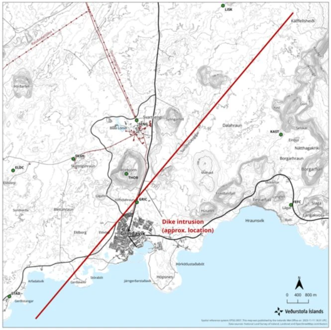
- Dike intrusion confirmation: GPS and satellite imagery subsequently confirmed a dike intrusion extending from Sundhnjúkagig through Grindavík and southwestward.
- Observation of unprecedented ground deformation: Data revealed that the rate of ground deformation in the area is significantly higher than any previously recorded levels on the Reykjanes Peninsula.
- Magma accumulation analysis: It was noted that the volume of magma accumulated has now surpassed that of the previous three eruptions in the area.
- Extent of magma intrusion: Further data analysis indicated that the magma intrusion extends from Stóra-Skógsfell in the north to Grindavík in the south, extending beneath the sea.
- Magma intrusion depth determination: The shallowest depth of the magma intrusion north of Grindavík was identified as 800 m (2 600 feet).
- Magma movement detection: Instruments showed clear signs of magma moving toward the surface.
- Comprehensive hazard assessment: At a status meeting held at 18:00 UTC today, a 15-km (9.3 miles) long dike intrusion was identified just northwest of Grindavík, representing a significant volcanic hazard.
- Emergency response initiation: In response to these findings, the Civil Defense declared a state of emergency on November 10 and ordered the evacuation of Grindavík, with a population of 2 856, to mitigate potential risks.
The focus of the meeting was to analyze the most recent measurements of seismicity and ground deformation in the Grindavík region, as well as to review current geophysical models and hazard assessments. A key finding from the combined assessments, which included satellite radar imagery, ground-based GPS measurements, and seismic data, is the identification of a 15-km (9.3 miles) long dike intrusion, located just northwest of Grindavík. This dike intrusion presents a significant volcanic hazard.
Geophysical modeling of the intrusion suggests that the magma is propagating upwards, currently estimated to be at a depth of approximately 800 m (2 600 feet) beneath the surface.
The exact location for a potential eruption site remains uncertain. However, the length and orientation of the dike provide strong indicators of possible eruption points. The meeting concluded with a consensus that the likelihood of a volcanic eruption is high, potentially occurring within a matter of days.
Given the extent of the dike, there is a possibility that magma could emerge south of the dike, just outside Grindavík. This scenario raises the prospect of a submarine eruption, which could lead to explosive volcanic activity due to the interaction of magma with seawater. Preparations are underway to address this increased risk.
A hazard area has been delineated based on the location of the dike, and authorities are closely monitoring the situation. This map, issued by the IMO, illustrates the area of concern and is critical for emergency planning and public safety:
Residents and visitors in the affected areas are urged to remain vigilant and to follow all safety instructions issued by local authorities.
“It is clear that we are dealing with events that we Icelanders have not experienced before, at least not since the eruption in the Westman Islands [1973. VEI 3]. We faced that together, we will face this together, and we will not be disheartened,” Víðir Reynisson, the Head of the Department of Civil Protection and Emergency Management said at a press conference held after 23:00 UTC on November 10, adding that evacuation is mandatory.
Additionally, significant infrastructural impacts were reported. Grindavíkurvegur, a key road leading to Grindavík from Reykjanesbrautin, was closed due to the formation of a large crack. Although emergency repairs were promptly carried out by the Road Administration, the road remains closed for safety reasons, as reported by Iceland Review.
By 01:00 UTC on November 11, the evacuation of Grindavík had been completed. In response to the emergency phase declared by the Department of Civil Protection and Emergency Management, the Red Cross set up three emergency relief centers to accommodate the evacuees. The evacuation process also included the relocation of residents from a residential facility for disabled individuals and a nursing home, both of which had suffered significant damage from the recent earthquakes.
References:
1 Significant likelihood of a volcanic eruption in the coming days – IMO – November 11, 2023
2 Emergency declared as record-high magma accumulation and intense earthquake swarm force Grindavík evacuation, Iceland – The Watchers – November 11, 2023
I'm a dedicated researcher, journalist, and editor at The Watchers. With over 20 years of experience in the media industry, I specialize in hard science news, focusing on extreme weather, seismic and volcanic activity, space weather, and astronomy, including near-Earth objects and planetary defense strategies. You can reach me at teo /at/ watchers.news.
As the Geomagnetic Field Reversal Rate Increases More, and More volcanoes will Erupt: Polar magnetic field reversal of any celestial body is always associated with the release of huge amount of excess energy from its surface. The build-up of this excess energy takes between 8-12 years in case of the Sun, but it takes thousands of years with regards to our planet. On the other hand, the Sun gets rid of the excess energy in forms of massive solar flares and other types of eruptions, while in the case of the Earth the massive release would be in the forms of volcanic eruptions and large magnitude earthquakes.
Line item 10 reads October 10, did you mean November 10?
Yes. Thank you