
Emergency declared as record-high magma accumulation and intense earthquake swarm force Grindavík evacuation, Iceland
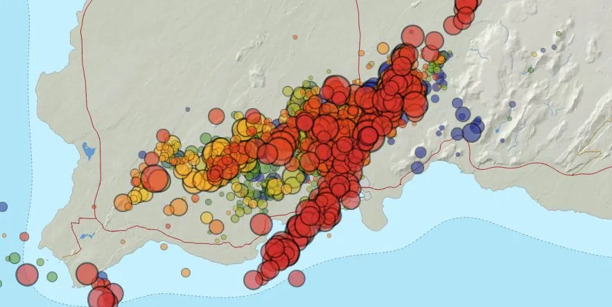
Image credit: IMO
In response to a significant escalation in seismo-volcanic activity on the Reykjanes Peninsula in Iceland, characterized by an exceptional accumulation of magma, the intrusion of a substantial dike, and an intense earthquake swarm, the Icelandic Meteorological Office (IMO) and Civil Defense authorities have implemented critical safety protocols on November 10, 2023. These measures include the mandatory evacuation of Grindavík and the proclamation of a state of emergency
Key takeaways:
- There is an ongoing intense seismic swarm north of Grindavík with increasing activity since 15:00 yesterday. The largest earthquake in the swarm was M5.0 at 18:00 UTC on October 10. It occurred 1 km (0.6 miles) east of Mt. Þorbjörn.
- The newest information from GPS and satellite images confirm a dike intrusion from Sundhnjúkagig through Grindavík and to the Southwest.
- The rate of ground deformation is much higher than has been measured previously on the Reykjanes Peninsula.
- The volume of magma that has accumulated has surpassed that of the previous three eruptions in the area.
- The data indicates that the magma intrusion extends from Stóra-Skógsfell in the north to Grindavík in the south, where it extends beneath the sea.
- The shallowest depth of the top of the magma intrusion north of Grindavík is 1.5 km (0.9 miles).
- Instruments show clear signs of magma movement towards the surface.
- Civil Defense declared a state of emergency on October 11 and ordered the evacuation of the city of Grindavik (population 2 856).
Since 15:00 UTC yesterday, a seismic swarm north of Grindavík has intensified, culminating in a magnitude 5.0 earthquake at 18:00 on November 10, just 1 km (0.6 miles) east of Mt. Þorbjörn. This seismic activity, the largest in recent memory for the area, has led to increased monitoring and analysis by geologists and seismologists.
Most of the recent earthquakes have occurred close to Grindavík, where the southwest end of the magmatic dyke is estimated to be located.
Recent GPS and satellite imagery have confirmed a significant dike intrusion, stretching from Sundhnjúkagíg through Grindavík, and extending southwest.
Remarkably, the rate of ground deformation observed is unprecedented for the Reykjanes Peninsula, indicating a much more extensive magma intrusion than previously experienced in the region.
The accumulated volume of magma has now surpassed the totals of the last three eruptions in this area.
Additionally, IMO instruments have detected clear indications of magma moving toward the surface, a worrying sign that heightens the possibility of an imminent eruption.
The magma intrusion is believed to extend from Stóra-Skógsfell in the north, passing through Grindavík, and reaching beneath the sea. Preliminary models suggest the shallowest depth of the magma’s top is currently at 1.5 km (0.9 miles) north of Grindavík.
In response to these developments, the Civil Defense declared a state of emergency on November 10 and ordered the complete evacuation of Grindavík, a town of 2 856 residents. This move follows the detection of an intense seismic swarm, with about 800 earthquakes recorded from midnight to noon. The seismic activity, though slightly diminished, remains high, emphasizing the seriousness of the situation.
During a press conference after 23:00 UTC on November 10, Víðir Reynisson, Head of the Department of Civil Protection and Emergency Management, reminded residents that the evacuation was mandatory and was being carried out with the safety of the residents in mind.
“It is clear that we are dealing with events that we Icelanders have not experienced before, at least not since the eruption in the Westman Islands [1973. VEI 3]. We faced that together, we will face this together, and we will not be disheartened,” Víðir said.
Grindavíkurvegur, a road leading to Grindavík from Reykjanesbrautin, was also closed last night due to a large crack that formed in the middle of it. The Road Administration has completed emergency repairs, but the road will remain closed, Iceland Review reported.
The town of Grindavík had been successfully evacuated by 01:00 UTC on November 11, with the Red Cross establishing three emergency relief centers in response to the emergency phase declared by the Department of Civil Protection and Emergency Management. In addition to the mandatory evacuation, a residential facility for disabled individuals and a nursing home were evacuated last night, following significant damage from recent earthquakes.
Residents and visitors are advised to stay informed and adhere to safety directives.
Update
A new update from the Icelandic Meteorological Office (IMO) at 18:30 UTC today has raised significant concerns about an imminent volcanic eruption. The latest data, stemming from a crucial status meeting involving the IMO, the University of Iceland, and the Department of Civil Protection and Emergency Management, points to a substantial risk of volcanic activity in the coming days.
A key finding from the combined assessments, which included satellite radar imagery, ground-based GPS measurements, and seismic data, is the identification of a 15-km (9.3 miles) long dike intrusion, located just northwest of Grindavík. This dike intrusion presents a significant volcanic hazard.
References:
1 The rate of ground deformation is much higher than has been measured previously on the Reykjanes Peninsula – IMO – November 11, 2023
2 Emergency Phase Declared and Grindavík Evacuated – Iceland Review – November 11, 2023
I'm a dedicated researcher, journalist, and editor at The Watchers. With over 20 years of experience in the media industry, I specialize in hard science news, focusing on extreme weather, seismic and volcanic activity, space weather, and astronomy, including near-Earth objects and planetary defense strategies. You can reach me at teo /at/ watchers.news.
Commenting rules and guidelines
We value the thoughts and opinions of our readers and welcome healthy discussions on our website. In order to maintain a respectful and positive community, we ask that all commenters follow these rules.