
Dangerous excessive rainfall event underway across much of Central California, widespread severe flooding expected
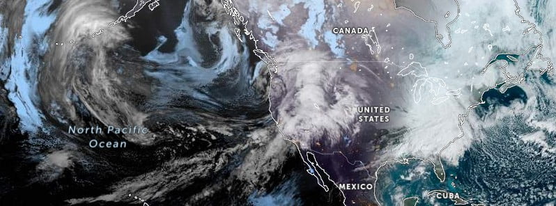
Image credit: NOAA/GOES-West, Zoom Earth, The Watchers. Acquired at 13:40 UTC on March 10, 2023
A dangerous excessive rainfall event, brought by a powerful atmospheric river, is underway across much of Central California today. Areal rainfall totals of 100 – 230 mm (4 – 9 inches) through today, atop areas with saturated soil and deep snowpack are expected to cause widespread and severe flooding impacts, particularly in the High Risk area.
- Areas that normally do not experience flash flooding will flood.
- Lives and property are in great danger from Friday into Saturday morning.
A front over the Pacific Northwest into Northern California will move eastward to the Tennessee Valley by Sunday, March 12, 2023, producing a strong winter storm, NWS forecaster Ziegenfelder noted.1
The storm will continue to affect the West Coast, particularly California, through Friday with a burst of heavy precipitation.
Warm air will be associated with the storm, with rain falling on existing snowpacks up to 2.6 km (8 500 feet).
The highest snow levels, heaviest rainfall, and highest rainfall rates are expected in Central California.
Considerable flooding impacts are possible across portions of the central coast and San Joaquin Valley. Rain and snowmelt will lead to flooding. The most significant snowmelt, and overall flooding threat, is expected below 1.5 km (5 000 feet) elevation in areas with shallow snowpack.
Creeks and streams in the foothills of the Sierra Nevada will be most vulnerable to flooding from rain and snowmelt. Furthermore, heavy wet snow will occur at higher elevations. The higher elevations in Northern California and the Sierra Nevada will receive heavy, wet snow.
The snow will lead to difficult travel and, combined with an already deep snowpack, may lead to increasing impacts from the depth and weight of the snow.
The Weather Prediction Center (WPC) has issued a rare High Risk of excessive rainfall over California through Saturday morning. Severe, widespread flash flooding is expected with the storm.
Areas that normally do not experience flash flooding will flood, NWS said, adding that lives and property are in great danger from Friday into Saturday morning.
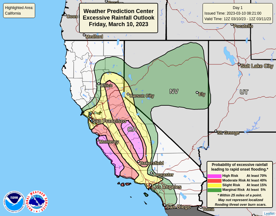
The threat of excessive rainfall will be significantly reduced on Saturday. Therefore, the WPC has issued a Marginal Risk of excessive rainfall over parts of California from Saturday into Sunday morning.
The associated heavy rain will create localized areas of flash flooding, affecting areas that experience rapid runoff and burn scars.
As the storm moves out of the Rockies onto the Plains, an area of showers and severe thunderstorms will develop over parts of the Southern Plains and Lower Mississippi Valley. Therefore, the Storm Prediction Center (SPC) has issued a Slight Risk of severe thunderstorms over parts of the Southern Plains and Lower Mississippi Valley from Saturday into Sunday morning. The hazards associated with these thunderstorms are frequent lightning, severe thunderstorm wind gusts, hail, and a few tornadoes.
Update
March 13
The storm left at least 2 people dead and nearly 10 000 under evacuation orders. More than 25 000 customers were left without power.
The California National Guard has deployed 36 high-water vehicles to respond to rescues.
A state of emergency was declared, clearing the way for financial help.
References:
1 Short Range Forecast Discussion – NWS Weather Prediction Center College Park MD – 253 AM EST Fri Mar 10 2023
I'm a dedicated researcher, journalist, and editor at The Watchers. With over 20 years of experience in the media industry, I specialize in hard science news, focusing on extreme weather, seismic and volcanic activity, space weather, and astronomy, including near-Earth objects and planetary defense strategies. You can reach me at teo /at/ watchers.news.
Commenting rules and guidelines
We value the thoughts and opinions of our readers and welcome healthy discussions on our website. In order to maintain a respectful and positive community, we ask that all commenters follow these rules.