
Intense Tropical Cyclone “Freddy” heading toward Madagascar and Mozambique
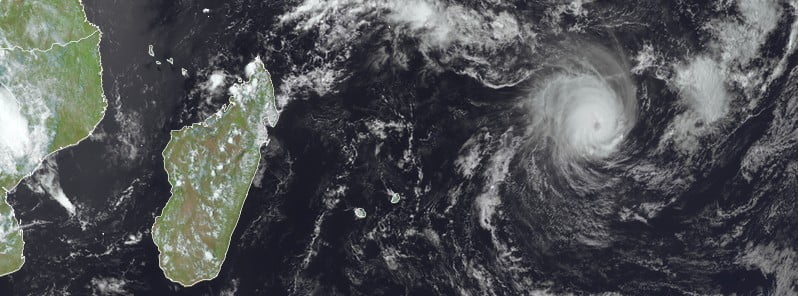
Featured image: Tropical Cyclone "Freddy" at 10:45 UTC on February 18, 2023. Credit: EUMETSAT/Meteosat-11, RAMMB/CIRA, The Watchers
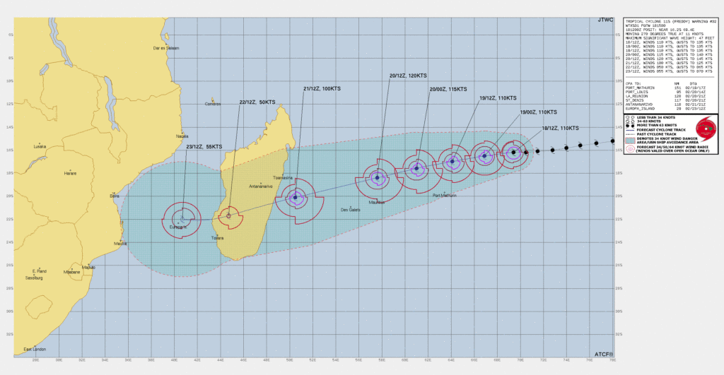
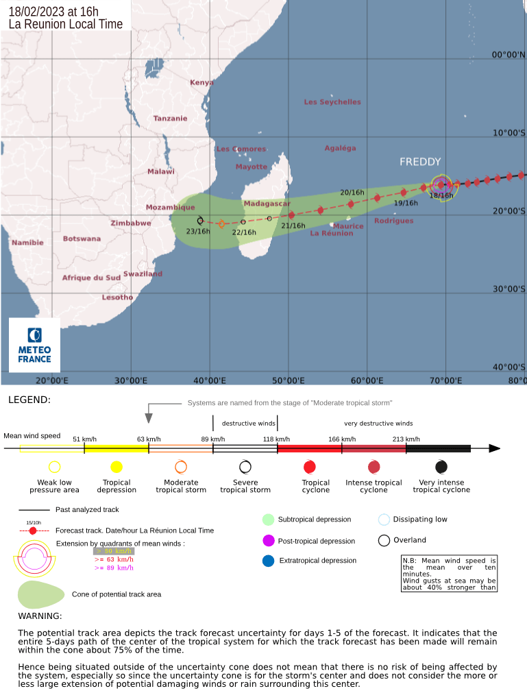
Tropical Cyclone “Freddy” is forecast to make landfall over the east-central coast of Madagascar on Tuesday, February 21, 2023, as an intense and very dangerous tropical system. The cyclone will then move over the island nation, exit into the Mozambique Channel on Wednesday and then re-intensify before making landfall over Mozambique.
Freddy formed on February 6, 2023, as the fourth named storm of the 2022/23 Australian region cyclone season. The system rapidly intensified and reached category 4 on the Australian scale before entering the South-West Indian Ocean on February 14. It continued to intensify, reaching a peak of 270 km/h (165 mph) on February 15, equivalent to a Category 5 tropical cyclone on the Saffir-Simpson scale.
At 12:00 UTC on February 18, Freddy’s center was located about 1 530 km (950 miles) ENE of Reunion and about 2 630 km (1 630 miles) east of Mayotte.
Its maximum 10-minute sustained winds were 185 km/h (115 mph), with gusts up to 260 km/h (160 mph), while maximum 1-minute sustained winds were 205 km/h (125 mph).
The minimum central barometric pressure was 950 hPa and the system was moving west at 19 km/h (12 mph), according to the RSMC La Reunion.
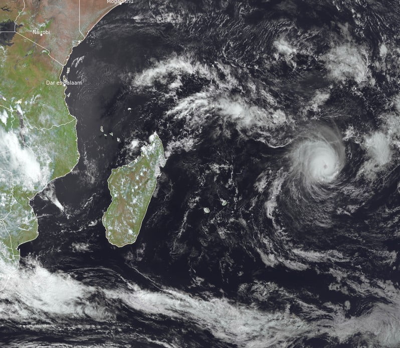
The cloud pattern in Freddy’s eye continues to fluctuate but shows a clear improvement compared to the previous bulletin, the center said in a bulletin released at 12:00 UTC today.
The eye is however less clear and shows an enlargement compared to 6 hours ago. The convective tops have cooled down well and define a better-structured ring. With the available data, it remains difficult to act on the realization of a replacement cycle of the eyewall. It is however notable that Freddy is regaining strength after a slight weakening period which is now over.
The Dvorak analysis in the eye allows an estimate of the winds in the order of 100 knots (185 km/h; 115 mph) as before, with a system that remains compact and that has begun a slight inflection towards the west-southwest. Freddy is still evolving north of the high geopotentials of the mid-troposphere on a westerly track, timidly moving towards the west-southwest under the effect of a slight eastward shift of the core of the subtropical ridge.
The forecasts of the various models remain little dispersed and stable, with a good confidence in a track passing to the north of the Mascarene Islands, but with a distance of passage that is slightly decreasing compared to the previous forecast of the RSMC.
“We can also notice a slight increase of the speed of movement, making Freddy circulate near the Mascareignes a little earlier, Then, as it approaches the Malagasy [Madagascar] coast, Freddy continues its acceleration,” RSMC forecasters said.
On Wednesday, February 22 as the system approaches the exit of the Mozambique Channel, the dispersion increases depending on a more or less marked weakness of the ridge south of Madagascar. On these scales, the RSMC forecast is close to the median of the main guidelines.
Freddy should intensify until its landing on Madagascar on Tuesday evening, but eventual cycles of replacement of the eyewall could limit and fluctuate the intensity of the system until its landing. At the end of the day, the conditions encountered by Freddy when it arrives in the Mozambique Channel suggest a re-intensification of the system.
Impacts on inhabited lands during the next 72 hours:
- Rodrigues Island: very rough sea 4 – 6 m (13 – 20 feet) Sunday afternoon and the following night.
- Mauritius Island: the arrival of gale is probable from Monday at 12:00 UTC. Most disturbed weather between Monday afternoon and early next night. Very rough sea 4-6 m (13-20 feet) becoming high (>6 m; >20 feet) during the day on Monday and the following night.
- Reunion: the arrival of gale is possible on Monday evening. Most disturbed conditions between Monday evening and Tuesday morning. High sea 4 – 6 m (13-20 feet) during the night from Monday to Tuesday.
Madagascar is still recovering from the passage of the extremely damaging Tropical Cyclone “Cheneso” in January 2023.
According to the National Office for Risk and Disaster Management (BNGRC), Cheneso left 33 people dead and 20 others missing. The agency also reports a total of 90 870 affected people, 34 100 of which were displaced. Around 23 600 homes and 164 schools suffered damage.
The arrival of Freddy to Mozambique will bring more heavy rains and strong winds to the country already heavily affected by widespread floods.
References:
1 RSMC / Tropical Cyclone Center La Reunion – Tropical Cyclone Forecast Warning (South-West Indian Ocean) #17/7/20222023. Intense Tropical Cyclone 7 (Freddy) – 12:00 UTC on February 18, 2023
I'm a dedicated researcher, journalist, and editor at The Watchers. With over 20 years of experience in the media industry, I specialize in hard science news, focusing on extreme weather, seismic and volcanic activity, space weather, and astronomy, including near-Earth objects and planetary defense strategies. You can reach me at teo /at/ watchers.news.
Commenting rules and guidelines
We value the thoughts and opinions of our readers and welcome healthy discussions on our website. In order to maintain a respectful and positive community, we ask that all commenters follow these rules.