
Massive winter storm to affect much of the U.S. this week, extremely disruptive impact on travel and livestock
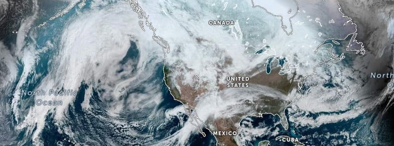
Image credit: NOAA/GOES, Zoom.Earth. The Watchers. Acquired at 20:10 UTC on February 19, 2023
A massive winter storm is expected to impact much of the U.S. this week with a variety of hazards. The storm will spread a large swath of heavy snow from the West Coast to the Northeast from Monday, February 20 to Thursday, February 23, 2023.
A prolonged winter storm is set to bring significant impacts to much of the West and the northern tier of the United States this week. Weather hazards include heavy snow, possible blizzard conditions, strong wind gusts and an icy wintry mix for portions of the Great Lakes and Northeast, NWS Weather Prediction Center warns.
The storm will spread a large swath of heavy snow from the West Coast to the Northeast from Monday to Thursday, February 23.
While subtle shifts in storm track remain possible, confidence is high that this winter storm will be extremely disruptive to travel, livestock and recreation in affected areas.
The combination of heavy snow and strong winds may result in blizzard conditions in parts of the West and Midwest with power outages and tree damage possible.
Very cold temperatures are likely from the West Coast into the Northern Plains behind this system with record lows and dangerous wind chills possible. The potential also exists for a flash freeze in portions of the northern Rockies on Tuesday, February 21.
Farther east, heavy snow and an icy wintry mix of snow, sleet, and freezing rain will impact the Great Lakes and Northeast later in the week. Treacherous travel conditions are possible in these areas.
“An energetic upper-level pattern, including a deepening trough over the West and a couple of frontal systems pushing southward over the western and central US, is expected to result in significant, widespread snowfall, as well as other hazardous weather conditions this week,” NWS forecaster Putnam noted in Short Range Forecast Discussion for February 20 – 23, released at 08:26 UTC on February 20.
Heavy snow has already started to spread southward early on Monday, through the Cascades and Northern Rockies, and it is expected to expand into California, the Great Basin, the Central Rockies and the Southwest through Tuesday, Putnam said. Many mountain ranges across the West are predicted to receive feet of snow, while lower-elevation interior valleys can expect to see a rain/snow mix with little to no snow accumulation.
Moderate to heavy snow showers are also expected to expand across the Northern Plains and into the Upper Midwest on Tuesday, continuing beyond the current forecast period into the day Wednesday. An axis of significant accumulating snow is likely from eastern Montana into the Dakotas and Minnesota/Wisconsin, with gusty winds leading to areas of blowing snow.
In addition to the snow, there will also be moderate to locally heavy rainfall, as well as isolated thunderstorm chances for the coastal Pacific Northwest. A cold front pushing southward, as well as a rapidly deepening surface low over the Great Basin, will lead to widespread strong, gusty winds on Tuesday across much of California, the Great Basin, and the Southwest.
A subtle shortwave aloft will drive a clipper frontal system across the northern tier of the country, bringing light to moderate snow to the Upper Midwest and Great Lakes on Monday and into the Interior Northeast by Tuesday. A broad swath of accumulating snow is expected across northern Minnesota, Wisconsin, and the Upper Peninsula of Michigan, with locally heavier totals possible in favorable lake and higher elevation locations across the Upper Peninsula of Michigan.
Portions of the Upper Midwest will see little break between this system and the impacts from the major winter storm approaching immediately thereafter. Accumulating snowfall should be more isolated to higher elevation mountains of the Interior Northeast. This clipper system, as well as a second frontal system to the south, will bring some light to moderate shower chances to the Southern/Central Appalachians and Mid-Atlantic on Monday and into coastal New England on Tuesday.
Temperatures across the central and eastern US will be upwards of 10 – 20 °F (5.5 – 11 °C) above normal on Monday, with highs in the 40s – 50s °F (4 – 10 °C) from the Lower Great Lakes into the Interior Northeast/New England, 50s and 60s °F (10 – 16 °C) for the Central Plains, Ohio Valley, and Mid-Atlantic, and into the 70s °F (21 – 27 °C) for the Southern Plains and Southeast, with some low 80s °F (27 – 30°C) for Texas and Florida.
Highs on Tuesday will be similarly above average for most locations, including 70s °F (21 – 27 °C) expanding northward into the Mid-Atlantic, with only the northern tier cooling off as the clipper system passes through.
It should be noted that in addition to the winter storm, another major weather story will be even more anomalously warm highs in the East, with numerous record-high maximum temperatures possible, as well as much below normal, record-low maximum/minimum temperatures across the West in the mid-to late week just beyond the current forecast period.
References:
1 Key Messages for Coast-to-Coast Major Winter Storm – NWS/WPC – February 20, 2023
2 Short Range Forecast Discussion- NWS Weather Prediction Center College Park MD – 326 AM EST Mon Feb 20 2023
I'm a dedicated researcher, journalist, and editor at The Watchers. With over 20 years of experience in the media industry, I specialize in hard science news, focusing on extreme weather, seismic and volcanic activity, space weather, and astronomy, including near-Earth objects and planetary defense strategies. You can reach me at teo /at/ watchers.news.
Commenting rules and guidelines
We value the thoughts and opinions of our readers and welcome healthy discussions on our website. In order to maintain a respectful and positive community, we ask that all commenters follow these rules.