
Roslyn forecast to rapidly strengthen into a hurricane before making landfall along the west-central coast of Mexico
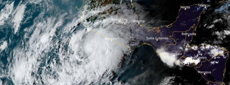
Featured image: Tropical Storm "Roslyn" at 23:10 UTC on October 21, 2022. Credit: NOAA/GOES-East, RAMMB/CIRA, The Watchers
Tropical Storm “Roslyn” is forecast to rapidly strengthen into a hurricane today and remain a hurricane when it passes near and makes landfall along the west-central coast of Mexico late Saturday and Sunday, October 22 and 23, 2022, accompanied by strong winds and a potentially dangerous storm surge.
- A Hurricane Warning is now in effect for a portion of the west-central coast of Mexico and will likely be extended northward later today
- Heavy rainfall could lead to flash flooding and possible landslides in areas of rugged terrain over coastal southwestern and west-central Mexico
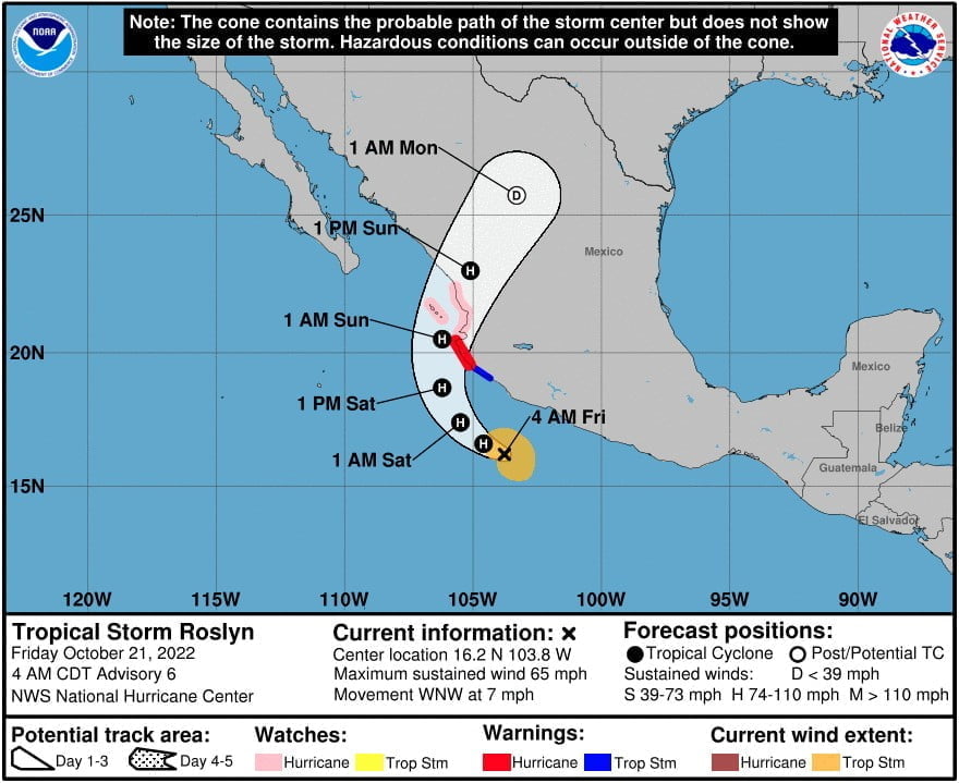
At 09:00 UTC on October 21, the center of Tropical Storm “Roslyn” was located about 315 km (195 miles) S of Manzanillo and 510 km (315 miles) SSE of Cabo Corrientes, Mexico.1
It had maximum sustained winds of 100 km/h (65 mph), minimum central pressure of 998 hPa, and was moving WNW at 11 km/h (7 mph).
A turn toward the NW and NNW is forecast tonight and Saturday, followed by a northward and then north-northeastward motion Saturday night and Sunday.
A Hurricane Watch is in effect for areas north of Cabo Corrientes to El Roblito; Las Islas Marias.
A Tropical Storm Warning is in effect for areas south of Playa Perula to Manzanillo
On the forecast track, the center of Roslyn will move parallel to the southwestern coast of Mexico today and tonight, and pass near and make landfall along the coast of west-central Mexico Saturday night (LT) and Sunday.
Rapid strengthening is expected during the next day or so, and the system is forecast to become a hurricane later today.
Roslyn is expected to still be a hurricane when it reaches the coast of west-central Mexico on Sunday, October 23.
Rapid weakening is expected after landfall, and although the official forecast shows a remnant low over northern Mexico in 72 hours for continuity, Roslyn is likely to have dissipated by that time.2
References:
1 Tropical Storm Roslyn Advisory Number 6 – NWS National Hurricane Center Miami FL – 400 AM CDT Fri Oct 21 2022
2 Tropical Storm Roslyn Discussion Number 6 – NWS National Hurricane Center Miami FL – 400 AM CDT Fri Oct 21 2022
I'm a dedicated researcher, journalist, and editor at The Watchers. With over 20 years of experience in the media industry, I specialize in hard science news, focusing on extreme weather, seismic and volcanic activity, space weather, and astronomy, including near-Earth objects and planetary defense strategies. You can reach me at teo /at/ watchers.news.
Commenting rules and guidelines
We value the thoughts and opinions of our readers and welcome healthy discussions on our website. In order to maintain a respectful and positive community, we ask that all commenters follow these rules.