
Earthquake swarm under Ta’u volcano continues, American Samoa
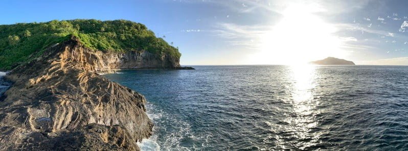
Featured image: An afternoon view of the tuff cone near Faleāsao village located in northwest Ta‘ū island, with the islands of Ofu and Olosega visible in the distance. This tuff cone, which is thousands of years old, formed when hot magma interacted with either shallow groundwater or sea water. There are several tuff cones located within the northwest corner of Ta‘ū island. Credit: USGS/D. Downs.
The earthquake swarm related to Taʻū Island, American Samoa, that started in late July 2022 continues. The Aviation Color Code remains at Yellow.
Data from the new seismometers confirms that the source location of earthquakes has not moved for many days. This tells us that the cause of the earthquakes has not shifted within the earth, the Hawaiian Volcano Observatory (HVO) said on August 30.1
The American Samoa Emergency Operations Center did not receive any felt reports for the past 24 hours. However, the USGS seismic network detected at least 30 earthquakes that were large enough to be felt by people on the Manuʻa Islands.
“It is unclear if this earthquake unrest will escalate to a volcanic eruption and exactly where an eruption might occur,” HVO said.
“An eruption could pose significant hazards to residents of American Samoa; these hazards include volcanic gases, volcanic ash, low-level localized explosions of lava, lava flows, earthquake shaking, and tsunami.”
The primary hazard of concern at this time is earthquake shaking, although no physically damaging earthquakes have occurred as part of this swarm.
In the coming weeks, USGS staff will install Global Positioning System (GPS) receivers to improve the Manuʻa Islands’ monitoring network. The GPS equipment will detect very slight movements of the ground. As a result, GPS data will help us better understand what is happening beneath the ground and provide more accurate hazard assessments.
Geological summary
The 10 km (6.2 miles) wide Ta’u Island, located at the E end of the Samoan islands, is ringed by sea cliffs. It is the emergent portion of the large Lata shield volcano.
A major flank collapse event around 22 ka resulted in the steep scarps on the southern side of the island. Two smaller shields were constructed along rift zones at the NW and NE tips of the island.
The NW corner of the island has a tuff-cone complex that ejected large dunite xenoliths and coral blocks. Numerous Holocene post-caldera cones occur at the summit and on the flanks.2
References:
1 HAWAIIAN VOLCANO OBSERVATORY DAILY UPDATE – U.S. Geological Survey – Tuesday, August 30, 2022, 03:13 UTC
2 Ta’u volcano – Geological summary – GVP
I'm a dedicated researcher, journalist, and editor at The Watchers. With over 20 years of experience in the media industry, I specialize in hard science news, focusing on extreme weather, seismic and volcanic activity, space weather, and astronomy, including near-Earth objects and planetary defense strategies. You can reach me at teo /at/ watchers.news.
Commenting rules and guidelines
We value the thoughts and opinions of our readers and welcome healthy discussions on our website. In order to maintain a respectful and positive community, we ask that all commenters follow these rules.