
Dangerous heat expected to extend from the Midwest to the Southeast, U.S.
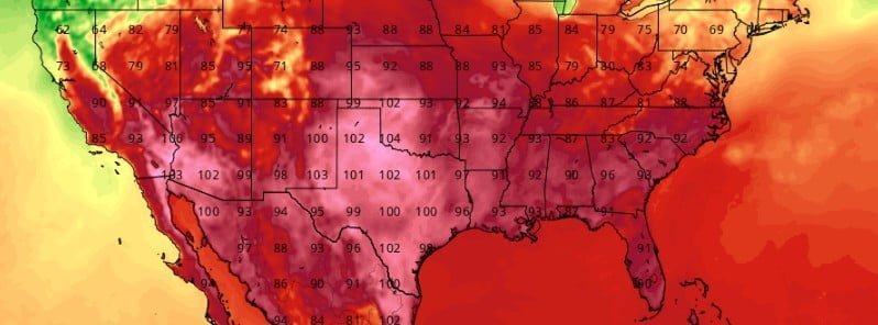
Image credit: TropicalTidbits/GFS
Record-setting heat will expand from the Southern and Central Plains into the Mississippi and Ohio Valley today. Excessive Heat Warnings are in place for Memphis, St. Louis, Minneapolis, and Tulsa. Dangerous heat is expected to extend from the Midwest to the Southeast through midweek.
After a weekend of record-breaking heat, a strong cold front is expected to introduce notably cooler temperatures across much of California and the Great Basin today, NWS forecaster Pereira noted.1
Farther east, the heat will persist, with well-above normal to record-breaking temperatures expected from the central and southern Rockies, across the Plains, and into the mid and lower Mississippi, Tennessee, and lower Ohio valleys.
With heat indices expected to easily reach triple digits in many locations, Heat Advisories and Excessive Heat Warnings cover much of the eastern Plains, the mid and lower Mississippi Valley, the lower Ohio Valley, the Tennessee Valley, and the central Gulf Coast Region.
As a strong upper high begins to build over the Tennessee Valley, the heat will build east into the Carolinas, with Heat Advisories now in effect for portions of the eastern Carolinas and coastal Georgia as well.
The heat will continue to shift farther northeast into the upper Mississippi Valley, western Great Lakes, and Ohio Valley, while continuing to build over the southern Mid Atlantic and Southeast on Tuesday, June 14.
Little change is expected on Wednesday, with many locations forecast to see back-to-back record-setting days.
As a result, power demand reached a new record in Texas on Sunday, June 12.
At around 17:15 LT, power demand in the state reached 74 917 megawatts, which was a record-breaking electric demand for Texas. The previous record was set on August 22, 2019, when power demand reached 74 820 MW, according to the Electric Reliability Council of Texas (ERCOT).
Showers and thunderstorms are expected to develop today ahead of the previously noted cold front as it begins to advance into the northern Plains later today, Pereira said.
Storms are also forecast to form near a warm front lifting across the Ohio Valley into the southern Great Lakes region today. Some of these storms may become strong to severe, with large hail, damaging winds, and a few tornadoes possible.
On Tuesday, strong to severe thunderstorms are possible once again across portions of the northern Plains into the Upper Midwest.
Severe storms may also develop across portions of the Mid-Atlantic into the Carolinas.
As temperatures soar across the Midwest into the eastern U.S., in contrast, daytime temperatures across the Northwest into the northern Great Basin and the northern Rockies are expected to be 5 – 11 C (10 – 20 F) below normal in some locations.
In addition to the anomalously cooler temperatures, precipitation will continue to fall across the region, including high elevation snows across portions of the northern Rockies.
Winter Storm Warnings and Advisories are in effect for the mountains of Northwest Montana, including the Glacier National Park area, where several inches of wet snow can be expected for elevations above 1 500 m (5 000 feet).
Flood Watches remain up for portions of western Washington and Oregon, northern Idaho, and northwestern Montana. With many rivers and streams at or near bankfull, any additional precipitation is expected to further elevate flooding concerns across the region.
An expansive area of critical fire weather conditions is expected across the Southwest into the southern and central Rockies and High Plains. Red Flag Warnings have been raised today for large portions of southeastern Utah, southwestern Colorado, northern and central Arizona and New Mexico today. Dry and windy conditions will promote the rapid spread of fires across these areas.
References:
1 Short Range Forecast Discussion – NWS Weather Prediction Center College Park MD – 409 AM EDT Mon Jun 13 2022
I'm a dedicated researcher, journalist, and editor at The Watchers. With over 20 years of experience in the media industry, I specialize in hard science news, focusing on extreme weather, seismic and volcanic activity, space weather, and astronomy, including near-Earth objects and planetary defense strategies. You can reach me at teo /at/ watchers.news.
Commenting rules and guidelines
We value the thoughts and opinions of our readers and welcome healthy discussions on our website. In order to maintain a respectful and positive community, we ask that all commenters follow these rules.