
Significant winter weather in the Southern and Eastern U.S., hazardous travel due to snow and ice
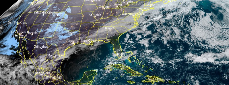
Image credit: NOAA/GOES-East. Acquired at 13:40 UTC on January 20, 2022
A wintry mix is expected today from the Ohio Valley into the Mid-Atlantic and southern New England along a cold front. One or more waves of low pressure tracking east along this front will likely bring areas of heavy snow and significant ice from south Texas into the Carolinas Thursday night, January 20 into Saturday morning, January 22, 2022.
- There is a risk of rain/freezing rain over parts of southern Texas and North Carolina today, January 20.
- Snow and a risk of significant rain/freezing rain over parts of the southern Mid-Atlantic on Friday, January 21.
A front extending from Southern New England southwestward to the Central Gulf Coast will be moving off most of the East and Gulf Coast by Thursday evening, January 20.1
A wave of low pressure along the boundary will linger over parts of the Southeast through Friday, and the rest of the front moving off the Southeast Coast by Saturday morning.
Rain changing over to snow will develop along the boundary from southern New England to the Central/Southern Appalachians on Thursday.
Along the rain/snow line, areas of light rain/freezing rain will develop over parts of eastern North Carolina on Thursday evening.
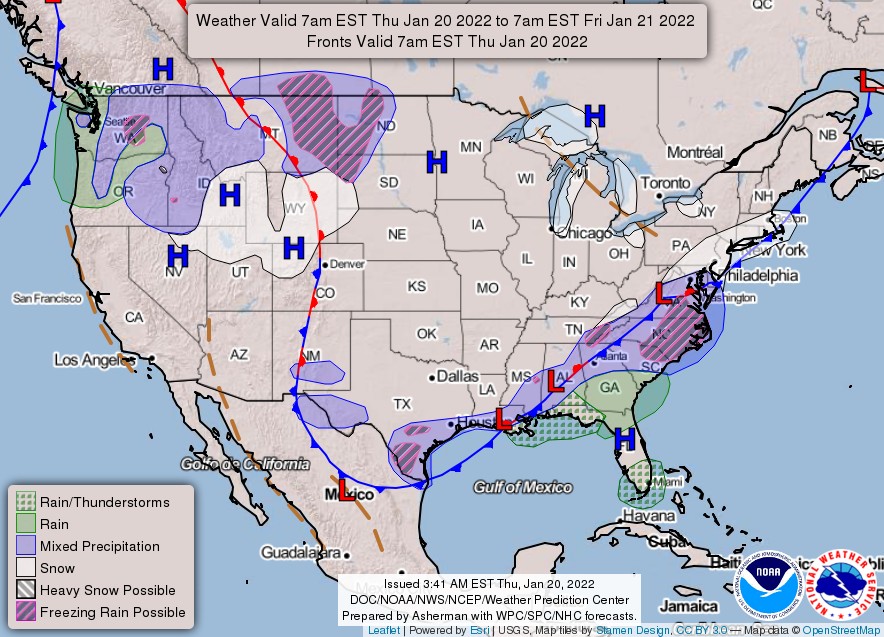
Furthermore, rain will also develop along the boundary from parts of the Central Gulf Coast to the Southeast on Thursday.
Incidentally, lake effect snow will develop downwind from the Great Lakes during Thursday.
Additionally, scattered rain/freezing rain will develop over southern Texas late on Thursday night.
Light snow will linger over parts of the southern Mid-Atlantic on Friday, while significant rain/freezing rain is expected over the Northern/Southern Carolina Coast.
While the snow and rain/freezing rain will end by Saturday morning, January 22, as the wave of low pressure slowly moves off the Southeast Coast, the rain will develop over the Southeast and parts of the Gulf Coast from Friday into Saturday morning.
The combination of snow and ice may cause hazardous road conditions.
Meanwhile, Wind Chill Warnings and Wind Chill Advisories are up over the Upper Midwest through noon local time.
References:
1 Short Range Forecast Discussion – NWS Weather Prediction Center College Park MD – 257 AM EST Thu Jan 20 2022
The Watchers team and our contributors bring the latest on extreme weather, earthquakes, volcanic eruptions, space weather, and all things science. We're all about making sense of the natural world and keeping you informed on what’s happening. Got a tip or a question? Hit us up using the form at newstips!
Commenting rules and guidelines
We value the thoughts and opinions of our readers and welcome healthy discussions on our website. In order to maintain a respectful and positive community, we ask that all commenters follow these rules.