
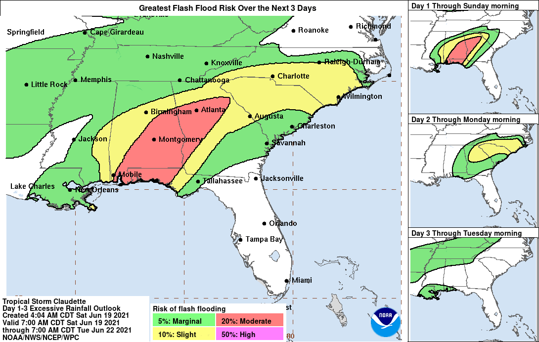
TC Claudette – Life-threatening flash flooding expected across coastal Mississippi and Alabama, and the far western Florida Panhandle
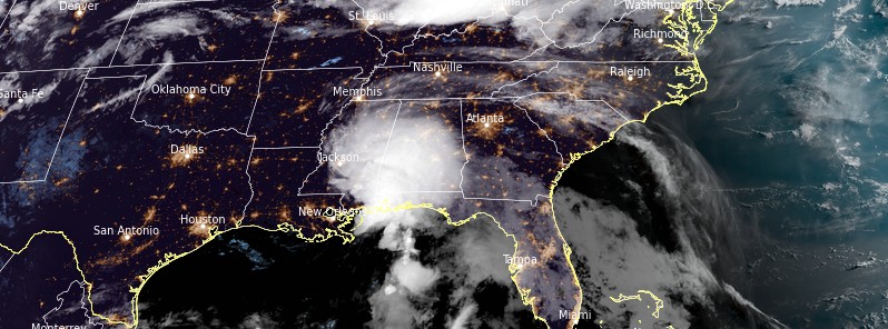
Featured image: Tropical Storm "Claudette" at 11:00 UTC on June 19, 2021. Credit: NOAA/GOES-East, RAMMB/CIRA, TW
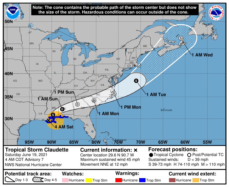
Tropical Storm "Claudette" formed at 09:00 UTC on June 19, 2021, as the third named storm of the 2021 Atlantic hurricane season. Heavy rainfall causing dangerous flooding remains the primary hazard, NHC warns. Claudette is expected to move farther inland over Louisiana during the next several hours, then move across portions of the Gulf Coast and southeastern states through the weekend, and over the western Atlantic Ocean on Monday, June 21.
- Claudette is expected to produce heavy rainfall and life-threatening flash flooding across coastal Mississippi and Alabama, and the far western Florida Panhandle through the afternoon. Considerable flash, urban, and small stream flooding, will continue through the weekend along the central Gulf Coast, with flood impacts spreading northeastward into interior portions of the Southeast.
- Tropical storm conditions are occurring along portions of the central Gulf Coast from east of Morgan City, Louisiana, to the Okaloosa/Walton County line, Florida, including New Orleans. These winds will spread inland and continue through this afternoon.
- Claudette is the 5th earliest 3rd Atlantic named storm formation since 1950.
At 09:00 UTC on June 19, the center of Tropical Storm "Claudette" was located bout 75 km (45 miles) SW of New Orleans, Louisiana and 280 km (175 miles) WSW of Mobile, Alabama.
Its maximum sustained winds were 75 km/h (45 mph) and minimum central pressure 1 006 hPa.
The storm was moving NNE at 19 km/h (12 mph).
A turn toward the northeast is expected later today, with a turn toward the east-northeast expected by tonight or Sunday.
On the forecast track, the system should move farther inland over Louisiana during the next several hours, then move across portions of the Gulf Coast and southeastern states through the weekend, and over the western Atlantic Ocean on Monday, June 21.
Claudette is expected to weaken to a tropical depression by tonight and become a post-tropical cyclone on Sunday. The system is forecast to re-develop over the western Atlantic Ocean on Monday.
A Tropical Storm Warning is in effect for locations east of Morgan City, Louisiana to the Okaloosa/Walton County line in Florida as well as Lake Pontchartrain, Lake Maurepas, and Metropolitan New Orleans.
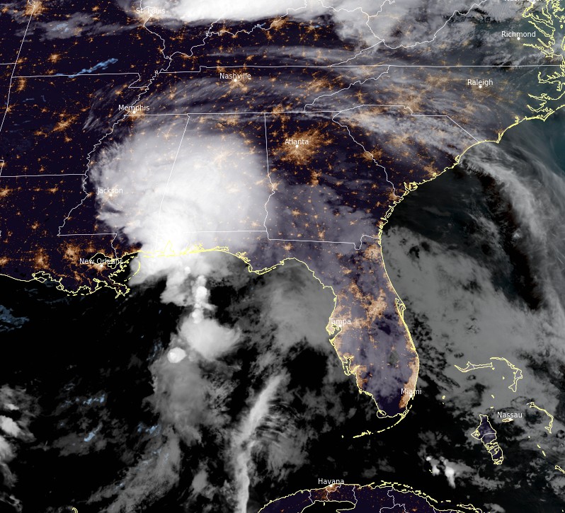
Tropical Storm "Claudette" at 11:00 UTC on June 19, 2021. Credit: NOAA/GOES-East, RAMMB/CIRA, TW
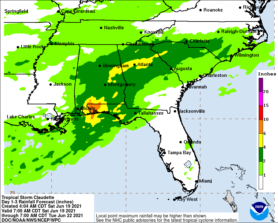
Claudette is expected to produce rainfall totals of 125 to 250 mm (5 to 10 inches) with isolated maximum amounts of 380 mm (15 inches) across portions of the central Gulf Coast.
Life-threatening flash flooding impacts are possible across coastal Mississippi and Alabama, and the far western Florida Panhandle through the afternoon.
Considerable flash, urban and small stream flooding impacts as well as new and renewed minor to isolated moderate river flooding are likely across the remainder of the Central Gulf Coast.
As the system continues to lift northeast through the weekend, heavy rain will expand across central Alabama, central and northern Georgia, into the Piedmont of the Carolinas, resulting in rainfall totals of 75 – 150 mm (3 to 6 inches) with isolated maximum amounts of 8 inches.
Flash, urban, small stream and isolated minor river flooding impacts are possible.
The combination of storm surge and the tide will cause normally dry areas near the coast to be flooded by rising waters moving inland from the shoreline.
The water could reach the following heights above ground somewhere in the indicated areas if the peak surge occurs at the time of high tide…
- Morgan City, LA to Okaloosa/Walton County Line, FL 0.6 – 0.9 m (2 – 3 feet)
- Lake Borgne and Mobile Bay 0.6 – 0.9 m (2 – 3 feet)
- Lake Pontchartrain and Lake Maurepas 0.3 – 0.6 m (1 – 2 feet)
- Okaloosa/Walton County Line, FL to Panama City, FL 0.3 – 0.6 m (1 – 2 feet)
- Pensacola Bay, Choctawhatchee Bay, and Saint Andrew Bay 0.3 – 0.6 m (1 – 2 feet)
- Cameron, LA to Morgan City, LA 0.3 – 0.6 m (1 – 2 feet)
- Vermilion Bay 0.3 – 0.6 m (1 – 2 feet)
Surge-related flooding depends on the relative timing of the surge and the tidal cycle, and can vary greatly over short distances.
Tropical storm conditions should continue along the coast in the warning area today.
A few tornadoes are possible today and tonight across southern Mississippi, southern Alabama, the western Florida Panhandle, and southwest Georgia.
I'm a dedicated researcher, journalist, and editor at The Watchers. With over 20 years of experience in the media industry, I specialize in hard science news, focusing on extreme weather, seismic and volcanic activity, space weather, and astronomy, including near-Earth objects and planetary defense strategies. You can reach me at teo /at/ watchers.news.
Commenting rules and guidelines
We value the thoughts and opinions of our readers and welcome healthy discussions on our website. In order to maintain a respectful and positive community, we ask that all commenters follow these rules.