
Increased seismic activity at Gareloi volcano, Aviation Color Code raised to Yellow, Alaska
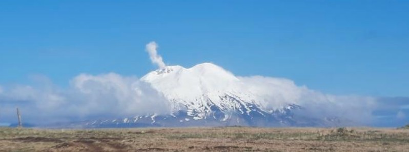
Featured image: Steaming Gareloi volcano on May 23, 2021. Credit: Adam McComb
A slight increase in seismic activity was observed at Gareloi volcano, Alaska on May 18, 2021, and beginning May 27 there has been a sustained increase in the rate and size of small volcanic earthquakes.
Because the level of seismic activity is now above the background, the Alaska Volcano Observatory (AVO) has raised the Aviation Color Code to Yellow and the Volcano Alert Level to Advisory at 17:43 UTC on June 8.
There have been no other notable changes at the volcano in satellite data or web camera views, AVO said.
Sulfur dioxide gas was detected in satellite imagery from Gareloi over the past week and is consistent with measurements from the last several years. No activity was observed by an AVO field crew flying over the summit on May 23.
Gareloi volcano persistently emits magmatic gases from a fumarole field on the south crater and commonly exhibits low-level seismic activity.
These observations suggest the presence of shallow magma and potential interaction with a hydrothermal system.
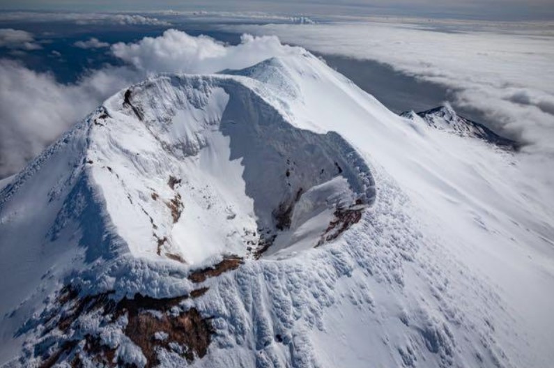
Aerial photo of the summit of Gareloi volcano, looking south. Kavalga Island is in the upper left for reference. The enclosed crater sits atop the volcano's north peak, which is its true summit. Note the relatively snow-free area on the north side of the cone. Beyond the north peak crater, the north rim of the south peak crater is visible, with a white steam plume coming from the persistent fumarole on the west rim of the south peak crater. Credit: AVO/USGS, Dane Ketner
The current increase in seismicity likely reflects a change to the magmatic-hydrothermal system, but it is not clear that the likelihood of a volcanic eruption has increased.
AVO added it will continue to monitor activity to determine if the recent changes are related to influx of new magma or other changes to the magma system.
Gareloi is monitored by a local seismic and infrasound network, satellite data, and regional infrasound and lightning-detection networks.
Geological summary
The 8 x 10 km (4.9 x 6.2 miles) Gareloi Island, the northernmost volcano of the Delarof Group at the western end of the Andreanof Islands, consists of a stratovolcano with two summits and a prominent SE-trending fissure.
The fissure was formed during an eruption in 1929 and extends from the southern summit to the sea. Steep sea cliffs that are cut into rocks of an older, eroded center are found on the SW coast, and submarine deposits of three debris avalanches produced by edifice collapse are found offshore.
Young lava flows cover the older volcano from the summit to the coast along three broad axes trending NW, ENE, and S.
The 1929 eruption originated from 13 craters along a 4 km (2.4 miles) long fissure.
Phreatic explosions were followed by the ejection of glassy pumice, lapilli, scoria, and older blocks, as well as by the emission of four short, steep lava flows, one of which reached the SE coast.
This volcano is located within the Aleutian Islands, a UNESCO Biosphere Reserve property. (GVP)
I'm a dedicated researcher, journalist, and editor at The Watchers. With over 20 years of experience in the media industry, I specialize in hard science news, focusing on extreme weather, seismic and volcanic activity, space weather, and astronomy, including near-Earth objects and planetary defense strategies. You can reach me at teo /at/ watchers.news.
Commenting rules and guidelines
We value the thoughts and opinions of our readers and welcome healthy discussions on our website. In order to maintain a respectful and positive community, we ask that all commenters follow these rules.