
Record cold grips eastern U.S. over the Memorial Day weekend
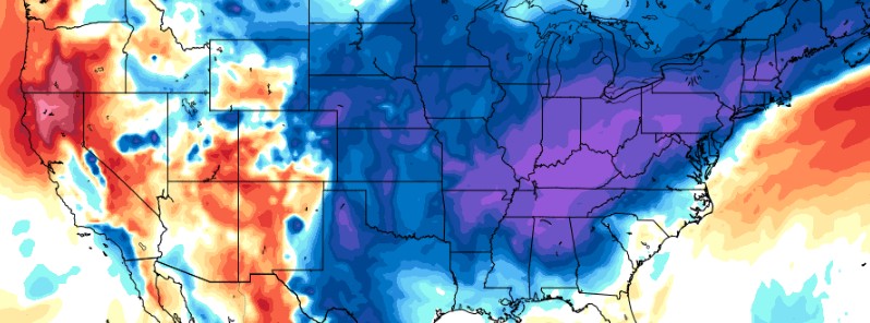
Featured image: 850 hPa Temperature Anomaly for May 30, 2021. Credit: TropicalTidbits
Numerous cold temperature records have been broken in parts of the eastern U.S. over the Memorial Day weekend while a heat wave is forecast to reach dangerous levels for some locations in the west, according to the National Weather Service (NWS). In addition to the unseasonal cold in the east, some of the highest elevations saw fresh snow. Meanwhile, in the west, Excessive Heat Warnings and Heat Advisories are in place for areas where heat-related illnesses are possible.
Much of the eastern half of the United States, particularly the Mid-Atlantic and the Northeast, experienced a cold Memorial Day weekend. On Saturday, May 29, numerous locations in the east set records for their coldest high temperatures or came very close.
"More than two dozen locations from Ohio and Kentucky, eastward to southern New England either broke or tied daily records for lowest high temperature on May 29," AccuWeather reported.
"In addition, record low temperatures were broken or tied across portions of the Great Lakes, Northeast and other areas in the northern tier of the country."
Boston's 10 °C (50 °F) was colder on Saturday, May 29 than it was on either Christmas or St. Patrick's Day.
Washington's 15 °C (59 °F) was the second coldest on record for May 29 and the coldest high temperature this late in the spring since 1997, when the temperature was 14.4 °C (58 °F) on June 3.
Baltimore's 14.4 °C (58 °F) was its coldest on record (since the late 1880s), as well as Philadelphia's 12.2 °C (54 °F) and Pittsburgh 10.6 °C (51 °F). New York City's 10.6 °C (51 °F) tied the coldest temperature on record, while Albany's 10 °C (50 °F) was its coldest.
Several areas in the Northeast also had record cold minimum temperatures, while the snow was observed in the mountains of Vermont.
"In addition to the unseasonable chill and rain, some of the highest elevations in the Northeast even woke up to a fresh coating of slushy snow to start the holiday weekend," AccuWeather added.
By Sunday, May 30, the cold was diminishing over the Mid-Atlantic and the Northeast, centering around Washington and Baltimore.
"A cool, damp northeasterly flow that wrapped around a storm tracking through the Northeast is generally to blame for the cold and gray weekend," said AccuWeather meteorologist Brandon Buckingham.
"As moisture-laden air from the Atlantic Ocean wrapped around the storm, it tended to get wedged in areas from the Appalachian Mountains to the Atlantic Coast, resulting in cloudy skies, drizzle, and in some cases, a steady rainfall," he explained.
Areas that experienced temperatures indicative of July at midweek were subjected to weather whiplash to start the weekend as temperatures were generally closer to those of April or even March: https://t.co/eAT6Ud8xtL pic.twitter.com/hPkPxi92Bo
— AccuWeather (@breakingweather) May 30, 2021
Areas of the Northeast that were soaked over the holiday weekend will get a brief reprieve from wet weather before daily showers & thunderstorms return later this week: https://t.co/M0YzAESMp4 pic.twitter.com/C1vCOwcnWj
— AccuWeather (@breakingweather) June 1, 2021
Following a rare late-season cold snap that made it feel like March rather than the unofficial start of summer in the Northeast, a return to warmer weather is ahead, but AccuWeather meteorologists caution that a break from rain will be short-lived: https://t.co/RGmpPDj96l pic.twitter.com/mxSKduDmZr
— AccuWeather (@breakingweather) June 1, 2021
While scores of record cold temperatures gripped the east, historic heat is expected to sweep across the wast to start the month of June.
"The western United States is wasting no time to start meteorological summer as high temperatures are forecast to soar well above average from the Desert Southwest to the Pacific Northwest through at least Thursday (June 3)," the NWS stated.
"Simmering and record-breaking heat will be particularly likely today from central California to northwest Oregon, before expanding into the northern Great Basin on Wednesday (June 2)."
High temperatures are forecast to spread as far north as central Washington and likely north-central Montana. Some locations are at risk of facing daily record hot temperatures Tuesday and Wednesday.
Excessive Heat Warnings and Heat Advisories have been issued for areas where heat-related illnesses are likely if precautions are not taken, added NSW.
High temperatures Tuesday afternoon may tie or break daily records for maximum temperatures ever measured in Fresno, Hanford, Merced, and Madera on June 1st. An Excessive Heat Warning is valid until 8 PM PDT Tuesday evening. Reduce time outdoors and drink plenty of water. #CAwx pic.twitter.com/N9mXbVg7C2
— NWS Hanford (@NWSHanford) May 31, 2021
Excessive Heat Watch has been issued for WED & THURS which includes:
Las Vegas
Pahrump
Lake Mead Nat'l Rec Area
Laughlin/Bullhead City
Lake Havasu City
Death Valley NP#nvwx #cawx #azwx pic.twitter.com/S2yCTygI2o— NWS Las Vegas (@NWSVegas) May 30, 2021
A shift in the weather pattern in the upper levels of the atmosphere will allow unseasonable heat to build across the West: https://t.co/fNTLhW16Bx pic.twitter.com/v7VXGs45ts
— AccuWeather (@breakingweather) May 30, 2021
It will be in the low 100s F in Las Vegas during the opening days of June as a heatwave builds over the western US: https://t.co/fNTLhW16Bx
— AccuWeather (@breakingweather) June 1, 2021
Commenting rules and guidelines
We value the thoughts and opinions of our readers and welcome healthy discussions on our website. In order to maintain a respectful and positive community, we ask that all commenters follow these rules.