
Increased activity at Pacaya volcano, Guatemala
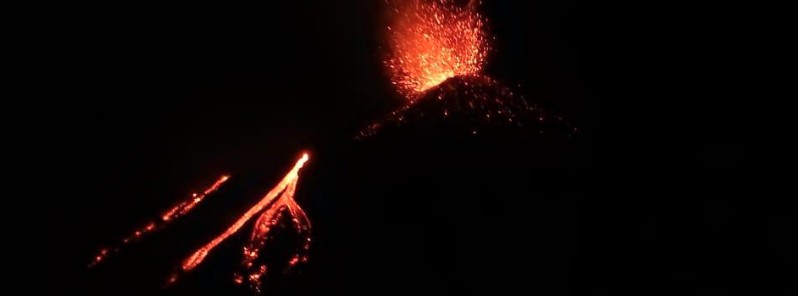
Image credit: Nancy de Ozaeta, COLRED Concepción El Cedro.
A period of increased volcanic activity started at Guatemala's Pacaya volcano on Thursday, October 8, 2020, with intense Strombolian activity ejecting volcanic material up to 300 m (984 feet), ash emissions and at least 4 lava flows. Pacaya is a highly active basaltic volcano with frequent lava flows and Strombolian explosions originating in the Mackenney crater.
Volcanic ash is extending about 12 km (7.4 miles) to the west of the volcano, INSIVUMEH reports.
The current activity is creating 4 lava flows on the northern and eastern flank with a length of 250 and 300 m (820 and 300 feet).
Explosions at Pacaya volcano on October 8, 2020
Atmospheric conditions are allowing visual observation of lava flows from various parts of the capital city.
New lava flows are possible and a further increase in activity is not ruled out, INSIVUMEH noted.
VOLCÁN PACAYA. En Caldero Los Llanos, Villa Canales se realiza visita de campo y monitoreo al volcán Pacaya, en el recorrido participa la Coordinadora Local para la Reducción de Desastres -COLRED-.
Fuente: Sergio Girón, Delegado Departamental de la CONRED. pic.twitter.com/1uFTJXhM64— CONRED (@ConredGuatemala) October 9, 2020
La actividad efusiva del #VolcánPacaya forma 4 flujos de lava en el flanco Norte y Este; debido a las condiciones atmosféricas es posible observar los flujos de lava desde varios puntos de la Ciudad Capital.
Vídeo: Claudio Castañón. pic.twitter.com/yl82iovddX— CONRED (@ConredGuatemala) October 9, 2020
— Marcos aguilar (@Marcosa68073981) October 9, 2020
People who live in areas near the Pacaya volcano are recommended to attend to the information shared by local authorities, review their Family Response Plan and have the 72-hour backpack ready for each member of the family.
To the residents and tourists, avoid approaching the Pacaya volcano area.
Geological summary
Eruptions from Pacaya, one of Guatemala's most active volcanoes, are frequently visible from Guatemala City, the nation's capital. This complex basaltic volcano was constructed just outside the southern topographic rim of the 14 x 16 km (8.7 x 9.9 miles) Pleistocene Amatitlán caldera. A cluster of dacitic lava domes occupies the southern caldera floor.
The post-caldera Pacaya massif includes the ancestral Pacaya Viejo and Cerro Grande stratovolcanoes and the currently active Mackenney stratovolcano.
The collapse of Pacaya Viejo between 600 and 1 500 years ago produced a debris-avalanche deposit that extends 25 km (15 miles) onto the Pacific coastal plain and left an arcuate somma rim inside which the modern Pacaya volcano (Mackenney cone) grew.
A subsidiary crater, Cerro Chino, was constructed on the NW somma rim and was last active in the 19th century.
During the past several decades, activity has consisted of frequent strombolian eruptions with intermittent lava flow extrusion that has partially filled in the caldera moat and armored the flanks of Mackenney cone, punctuated by occasional larger explosive eruptions that partially destroy the summit of the growing young stratovolcano. (GVP)
I'm a dedicated researcher, journalist, and editor at The Watchers. With over 20 years of experience in the media industry, I specialize in hard science news, focusing on extreme weather, seismic and volcanic activity, space weather, and astronomy, including near-Earth objects and planetary defense strategies. You can reach me at teo /at/ watchers.news.
Commenting rules and guidelines
We value the thoughts and opinions of our readers and welcome healthy discussions on our website. In order to maintain a respectful and positive community, we ask that all commenters follow these rules.