Bahamas bracing for Hurricane “Isaias”
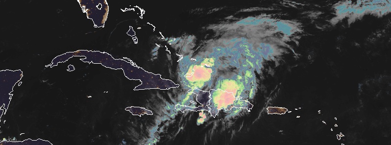
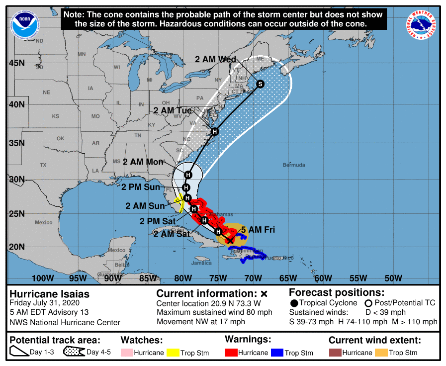
Tropical Storm "Isaias" — the 9th named storm of the 2020 Atlantic hurricane season — has strengthened into a hurricane at 03:40 UTC on July 31, 2020. At the time, its center was located about 110 km (70 miles) ESE of Great Inagua Island, Bahamas, moving NW at 30 km/h (18 mph). NHC forecast calls for the center of Isaias to move near or over the southeastern Bahamas on Friday, July 31, 2020. Preparations to protect life and property should be rushed to completion. Future forecast track remains uncertain at this time, but there is a notable chance of a hurricane moving close to the U.S. East Coast. Heavy rains associated with Isaias may begin to affect South Florida and east-Central Florida beginning late tonight (LT), potentially resulting in isolated flash and urban flooding, especially in low-lying and poorly drained areas.
At 04:00 UTC, the government of the Bahamas has issued a Hurricane Warning for the central and southeastern Bahamas, which include the Acklins, Crooked Island, Long Cay, the Inaguas, Mayaguana, the Ragged Islands, Cat Island, the Exumas, Long Island, Rum Cay, and San Salvador.
At 09:00 UTC, the center of Hurricane "Isaias" was located just 25 km (15 miles) SSW of Great Inagua Island and about 620 km (385 miles) SE of Nassau. Its maximum sustained winds were 130 km/h (80 mph). The system had a minimum central pressure of 990 hPa and was moving NW at 28 km/h (17 mph), according to the NHC.
A Hurricane Warning is in effect for:
– Northwestern Bahamas including Andros Island, New Providence, Eleuthera, Abacos Islands, Berry Islands, Grand Bahamas Island, and Bimini
– Southeastern Bahamas including the Acklins, Crooked Island, Long Cay, the Inaguas, Mayaguana, and the Ragged Islands
– Central Bahamas, including Cat Island, the Exumas, Long Island, Rum Cay, and San Salvador
A Tropical Storm Warning is in effect for:
– Dominican Republic entire southern and northern coastlines
– North coast of Haiti from Le Mole St Nicholas eastward to the northern border with the Dominican Republic
– Turks and Caicos Islands
A Tropical Storm Watch is in effect for:
– East coast of Florida from Ocean Reef to Sebastian Inlet
– Lake Okeechobee
Interests elsewhere along the southeast coast of the United States should monitor the progress of this system, NHC said. Additional watches or warnings may be required for a portion of the Florida peninsula later today.
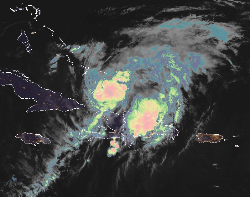
Hurricane "Isaias" at 09:00 UTC on July 31, 2020. Credit: NOAA/GOES-East, RAMMB/CIRA
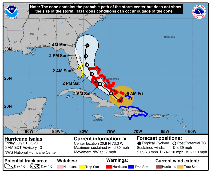
On the forecast track, the center of Isaias will move near or over the Southeastern Bahamas today. Isaias is forecast to be near the Central Bahamas tonight and move near or over the Northwestern Bahamas and near or east of the Florida peninsula on Saturday and Sunday.
"The hurricane has been moving between west-northwest and northwest during the last several hours," NWS forecaster Blake noted at 09:00 UTC.
It should gradually turn to the north-northwest and north over the weekend as it moves around the western periphery of a weakening western Atlantic subtropical ridge, Blake added.
Guidance is in fairly good agreement over the first couple of days of the forecast, so little change is made at that time, other than a small westward adjustment near the Bahamas.
"After that time, there is a considerable spread, growing to over 1 130 km (700 miles), in the reliable models on how quickly Isaias moves northeastward near the east coast of the United States. The large spread appears to be related to both how strong the cyclone is by early next week and how much mid-level ridging remains near the Carolinas."
Given this large spread, the extended forecast could be subject to large speed/timing changes.
Isaias is expected to continue strengthening during the next day or so while it remains over the very warm waters near the Bahamas with reasonably low vertical shear.
NHC key messages
1. Isaias will produce heavy rains and potentially life-threatening flash flooding and mudslides across the Dominican Republic, northern Haiti, Turks and Caicos, and the Bahamas. Heavy rains associated with Isaias may begin to affect South and east-Central Florida beginning late Friday night, July 31 and the eastern Carolinas by early next week, potentially resulting in isolated flash and urban flooding, especially in low-lying and poorly drained areas. Isolated minor river flooding is possible in the Carolinas early next week.
2. Hurricane conditions and dangerous storm surge are expected in portions of the Bahamas today and Saturday, and Hurricane Warnings are in effect for these areas. Preparations to protect life and property should be rushed to completion.
3. Tropical storm conditions are possible along portions of the Florida east coast beginning Saturday, August 1, and a Tropical Storm Watch remains in effect. While storm surge watches are not currently needed for this area, they may be required later today if the forecast track shifts closer to the coast. Heavy rains associated with Isaias may begin to affect South Florida and east-Central Florida beginning late tonight, potentially resulting in isolated flash and urban flooding, especially in low-lying and poorly drained areas.
4. There is a risk of impacts from winds, heavy rainfall, and storm surge late this weekend from the northeastern Florida coast and spreading northward along the remainder of the U.S. east coast through early next week. The details of the track and intensity forecast remain uncertain, and it is too soon to determine the magnitude and location of these potential impacts, but interests along the entire U.S. east coast should monitor the progress of Isaias and updates to the forecast.
Featured image: Hurricane "Isaias" at 09:00 UTC on July 31, 2020. Credit: NOAA/GOES-East, RAMMB/CIRA
Commenting rules and guidelines
We value the thoughts and opinions of our readers and welcome healthy discussions on our website. In order to maintain a respectful and positive community, we ask that all commenters follow these rules.