
Iota strengthens to strongest Atlantic hurricane of the year before making historic landfall in Nicaragua
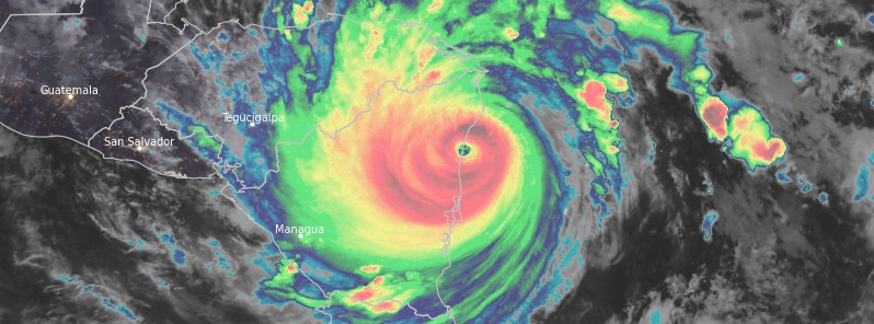
Featured image: Hurricane "Iota" at 03:40 UTC on November 17, 2020. Credit: NOAA/GOES-East, RAMMB/CIRA
Extremely dangerous Category 4 Hurricane "Iota" made landfall along the coast of northeastern Nicaragua on November 17 — just 24 km (15 miles) from the area struck by Category 4 Hurricane "Eta" on November 3 — with maximum sustained winds of 250 km/h (155 mph), just 2 km/h below Category 5 hurricane. With many parts of Nicaragua and Honduras still recovering from massive rain dropped by Eta, more extreme rainfall produced by Iota may lead to some of the worst floods the region has seen in a thousand years or more.
- Iota is still a significant hurricane, NHC said. Damaging winds and a life-threatening storm surge are expected along portions of the coast of northeastern Nicaragua during the next several hours, where a hurricane warning is in effect.
- Life-threatening flash flooding and river flooding is expected through Thursday, November 19 across portions of Central America due to heavy rainfall from Iota. Flooding and mudslides across portions of Honduras, Nicaragua and Guatemala could be exacerbated by Hurricane Eta's recent effects there, resulting in significant to potentially catastrophic impacts.
Iota strengthened into a Category 5 hurricane with maximum sustained winds of 260 km/h (160 mph) — the strongest of the 2020 Atlantic season — before it made landfall, and now ranks as the second-most intense November hurricane in the Atlantic ocean on record.
The strongest ever November hurricane in the Atlantic remains the 1932 Cuba hurricane — the deadliest and one of the most intense tropical cyclones to make landfall in Cuba. Together with Iota, the 1932 Cuba hurricane is the only Category 5 Atlantic hurricane ever recorded during the month of November.
Iota explosively intensified before landfall, 61 hPa in 24 hours (71 hPa in 36 hours) — which is far beyond the rapid deepening threshold. There are only 3 Atlantic hurricanes on record that have deepened more than 61 hPa in 24 hours — Gilbert in 1988, and Rita and Vilma in 2005. Iota is the only one in November. This rapid intensification rate makes Iota the 4th rapidly deepening hurricane of the 2020 season — which is the most in a single Atlantic season, and the largest deepening this year.
Iota is now the strongest November hurricane on record to make landfall in Nicaragua, surpassing the previous record set by Eta (230 km/h / 140 mph) just 13 days ago. Together with Eta, Hurricane "Iota" is now among the top 5 tropical cyclones ever to hit Nicaragua.
"Catastrophic flooding is anticipated because the ground is still saturated from Eta, and rain from Iota will run off into already swollen and flooded streams and rivers," AccuWeather CEO and Founder Dr. Joel N. Myers said. "The mountainous terrain will add to the dangers of flooding and mudslides."
"This may be one of the worst floods in some of these areas in a thousand years or more," Myers said. "Some of these countries may not completely recover for 5 to 10 years."
Myers compared Iota's looming impact to what Hurricane "Katrina" did to the U.S. Gulf Coast in 2005.
Iota made landfall near the town of Haulover, about 45 km (30 miles) south of Puerto Cabezas at 03:40 UTC on November 17 (22:40 EST, November 16). This is just 24 km (15 miles) south of where Hurricane "Eta" made landfall on November 3.
At the time of landfall, Iota had maximum sustained winds of 250 km/h (155 mph) and minimum central pressure of 920 hPa. It was moving W at 15 km/h (9 mph).
Hurricane "Iota" at 03:40 UTC on November 17, 2020. Credit: NOAA/GOES-East, RAMMB/CIRA
Hurricane "Iota" at 03:40 UTC on November 17, 2020. Credit: NOAA/GOES-East, RAMMB/CIRA
"Due to the previous damage caused by Eta, wind reports have been extremely limited," NHC forecaster Stewart said.
"There was an amateur radio report from Club de Radio-Experimentadores de Nicaragua of 200 km/h (124 mph), winds and roofs damaged in the town of Wilbi, Nicaragua. However, it is uncertain if these were sustained winds or wind gusts. At the Puerto Cabezas, Nicaragua, airport at 02:53 UTC measured a sustained wind of 134 km/h (83 mph) and a gust to 182 km/h (113 mph)."
At 06:00 UTC on November 17, Iota's center was located about 60 km (40 miles) SW of Puerto Cabezas and 165 km (105 miles) SSW of Cabo Gracias a Dios on the Nicaragua/Honduras border. Its maximum sustained winds dropped to 210 km/h (130 mph) and minimum central pressure increased to 935 hPa.
The storm is moving toward the west near 15 km/h (9 mph) and this general motion is expected to continue during the next day or so. Iota will move farther inland across northern Nicaragua this morning (EST) and move across southern Honduras Tuesday night.
Rapid weakening is expected to continue today and Wednesday, and Iota is expected to dissipate over Central America by Wednesday night, November 18.
.png)
A life-threatening storm surge will raise water levels by as much as 3 to 4.5 m (10 to 15 feet) above normal tide levels in areas of onshore winds along the coast of Nicaragua and Honduras, NHC warns.
Near the coast, the surge will be accompanied by large and destructive waves.
Catastrophic wind damage is occurring near Iota's eyewall and these winds will spread farther inland across northern Nicaragua during the next several hours.
Iota is expected to produce the following rainfall accumulations through Thursday:
Honduras, northern Nicaragua, southeast Guatemala and southern Belize: 250 to 500 mm (10 to 20 inches). Isolated maximum totals of 750 mm (30 inches) across northeast Nicaragua and northern Honduras.
El Salvador and Panama: 150 to 250 mm (6 to 10 inches), with isolated maximum totals of 380 mm (15 inches). This rainfall would lead to significant, life-threatening flash flooding and river flooding, along with mudslides in areas of higher terrain.
Southern Nicaragua and Costa Rica: 75 to 125 mm (3 to 5 inches), with isolated maximum totals of 250 mm (10 inches). This rainfall would lead to significant, life-threatening flash flooding and river flooding, along with mudslides in areas of higher terrain.
Southern Nicaragua and Costa Rica: 75 to 125 mm (3 to 5 inches), with isolated maximum totals of 250 mm (10 inches).
Swells generated by Iota will affect much of the coast of Central America and the Yucatan Peninsula during the next couple of days. These swells are likely to cause life-threatening surf and rip current conditions.
I'm a dedicated researcher, journalist, and editor at The Watchers. With over 20 years of experience in the media industry, I specialize in hard science news, focusing on extreme weather, seismic and volcanic activity, space weather, and astronomy, including near-Earth objects and planetary defense strategies. You can reach me at teo /at/ watchers.news.
The deflection of the magnetic poles is, as in the past, the cause of climate change. Green greed needs CO² as a cause, because CO² is taxable and the natural magnetic excursion is not, just like religion or sect you can use it as a sin, to realize your environmental policy..