
Large tornado rips through Jonesboro, causing extensive damage, Arkansas

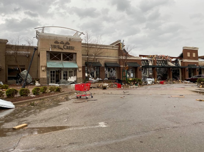
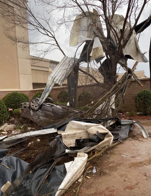
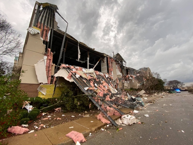
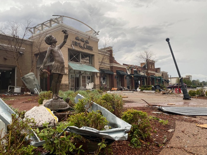
Featured image: Damage after large tornado hits Jonesboro, Arkansas on March 28, 2020. Credit: Jonesboro Police Department
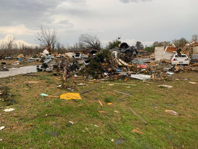
At least 22 people were injured and numerous buildings destroyed or damaged after a large tornado ripped through the city of Jonesboro, Arkansas on Saturday, March 28, 2020. There are no confirmed fatalities, but the damage is extensive. Early estimates suggest this could have been an EF-3 tornado or greater.
Severe thunderstorms hit areas from southern Plains to the Ohio Valley, bringing damaging winds, heavy rain, large hail, and at least 17 tornadoes — 8 in Iowa, 4 in Illinois, 3 in Arkansas, and one each in Missouri and Wisconsin.
A large tornado hit the City of Jonesboro, Arkansas at around 17:20 LT on Saturday, causing extensive damage, the National Weather Service said.
The twister ripped through Race and Caraway Streets, destroyed the Mall at Turtle Creek, numerous homes in neighborhoods, and continued on through Brookland, and the Arkansas – Missouri border.
Debris from Jonesboro was lofted more than 6.5 km (4 miles) high. "This has to be one of the most impressive debris signatures I've seen," said Matthew Cappucci, atmospheric scientist and meteorologist currently working for the Washington Post.
Unbelievable live stream of the Jonesboro, Arkansas tornado.
Incredible job by @ZachHolderWx & team at @Region8News. (https://t.co/OLG9gg9xvP) pic.twitter.com/9Hm0YjXAZm
— Dakota Smith (@weatherdak) March 28, 2020
Jonesboro Mayor Harold Perrin said Camfil's business area was destroyed.
Perrin issued a citywide curfew, effective 19:00 LT, March 28 to 07:00 LT, March 29 — no one is allowed to be on the roads or out of their homes.
"Stay home! Do not go walk/drive/explore. Our town is under a state of emergency and we are asking for full cooperation from citizens," Jonesboro Police Department said. "Officers are stationed all across town to enforce the curfew all night."
The curfew, however, does not affect those who have to go to work. "If you are stopped, tell the officer you are reporting to work," JPD said.
Highway 49 between Jonesboro and Brookland is closed to all traffic.


Images courtesy Jonesboro Police Department
Jonesboro Fire Department has implemented primary search and rescue tonight and will perform secondary in the morning.
"Any construction company that wants to help, or any persons with chainsaws, get in contact with the Office of Emergency Management," authorities said.
Unreal up close footage from Said Said in Jonesboro. He owns the Triple S Phones shop and stated the tornado came VERY quick.
Scary footage. I can’t imagine. @ReedTimmerAccu @JimCantore #arwx pic.twitter.com/KFWqpdKbEx
— Zachary Hall (@WxZachary) March 28, 2020
Areal footage of the mall #arwx @MallTurtleCreek pic.twitter.com/rugnql7rxg
— Madi Wilson (@_MadisonWilson) March 29, 2020
Unreal video of the #Jonesboro tornado. #arwx
— Aaron Nolan (@AaronNolanNews) March 28, 2020
Just arrived on Caraway. A lot of damage. Working on injuries @Region8News pic.twitter.com/BSPxwrFQtJ
— Jurnee Taylor (@_JurneeTaylor) March 28, 2020
"By Sunday morning, March 29, both the severe and flash flood threats will lessen but a few strong to severe thunderstorms are possible in the eastern Ohio Valley and Mid-Atlantic," NWS forecaster Mullinax noted on March 28.
Showers along with cooler and dreary conditions will be common in the Northeast while portions of northern New England receive accumulating snowfall. Snow totals in portions of northern Maine may exceed 150 mm (6 inches) with less snowfall closer to the coast.
In wake of this storm system, blustery conditions combined with low relative humidity levels will set the stage for a heightened risk for fire weather in the southern High Plains.
The Rio Grande River Valley, in particular, is under a critical risk for fire weather potential this afternoon.
In addition, drier conditions will arrive across the Mississippi and Ohio River Valleys Sunday while the Mid-Atlantic and Southeast bask in well above normal temperatures.
"High temperatures will soar into the 80s [~27 °C] from Virginia on south to the Southeast and Gulf Coasts. This taste of summer-like warmth will be short-lived as below normal temperatures over the Great Lakes Monday push into most southern and eastern regions by Tuesday, April 1.
I'm a dedicated researcher, journalist, and editor at The Watchers. With over 20 years of experience in the media industry, I specialize in hard science news, focusing on extreme weather, seismic and volcanic activity, space weather, and astronomy, including near-Earth objects and planetary defense strategies. You can reach me at teo /at/ watchers.news.
The infrasound heard before tornado occurs as a warning “beep” and may force you to save Your life “just in time”. Infrasounds created before variable events does´nt imagine a mystery, its only the necessary “equipment” for surviving animals because of the people have lost this ability thousends years ago. Every global event seems to be carry in infrasound frequency, but the local small events we can hear, when we limited our “frequency receiver” from 20 to 20 kHz. The material crashes, bomb explosions, shooting – all this events can we hear. Yet I will give You some equations to calculate the
tornado infrasound frequency before tornado strikes on the Earth.
Equation 1: The atmospheric pressure equals the inflow of airmass matter h*D*g=D*v2, h- high of fallen airmass, D-density of airmass, v – velocity of wind by inflow, thus
v= (hg)^0,5
Equation 2: The velocity of the airmass crates an infrasound beep if airmass begins to downward rotate, thus π*d*f = (hg)^0,5 and f = (hg)^0,5/(π*d), f – frequency of infrasound, d – tornado diameter, h – the high of supercell or cumulonimbus cloud, very rare of hurricane, g – gravitic acceleration.
Example: How big tornado tromb diameter will strike the Ground, when the high of supercell is 20 km and infrasound heard was 0,04 Hz?
Solution: π*d*f = (hg)^0,5 , thus d = (hg)^0,5/(π*f)
(20000*9,80665)^0,5/(π*0,04) = 3524,2399633930499893675966509987 meters
Answer: The future tornado tromb diameter will be 3,52424 km.