
Slow-moving nor’easter affecting parts of the Northeast, anomalously cold air mass drops into the Central USA
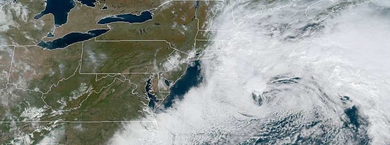
Image credit: NOAA/GOES-East
Heavy rain and gusty winds produced by a potent, slow-moving ocean storm / nor'easter are expected to linger over southeastern New England into Saturday, October 12, 2019. Meanwhile, an early-season major winter storm continues across the Northern Plains as an anomalously cold air mass drops into the Central U.S. and interacts with a vigorous storm system. Critical to extremely critical fire weather conditions continue across portions of Southern California due to gusty winds and a very dry airmass.
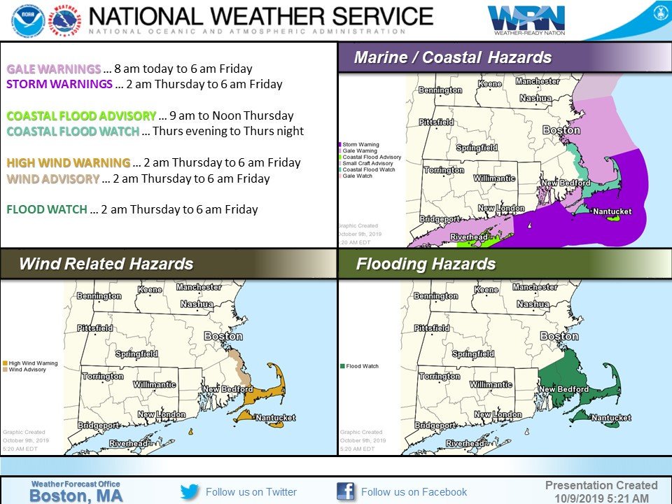
"A significant and potentially dangerous situation is unfolding which may catch some folks off guard as an early-season offshore ocean storm system develops," the NWS Boston office said Wednesday, October 9. "Plan accordingly and take action as necessary toward the protection of life and property."
The view of our #Noreaster from #GOES16 satellite. It's the counter clockwise swirl offshore which is strengthening and expanding in size with time. Its circulation impacting #MA #RI #CT with gusty northeast winds, periods of rain and cool temperatures pic.twitter.com/Qa2HLGnE3I
— NWS Boston (@NWSBoston) October 9, 2019
[11p] Looking at observed rainfall totals. Over 1-inch amounts have been observed across E-portions of CT into Central RI.
Additional rainfall to come esp across SE MA w/ the potential of seeing a storm-total of 6-8" of rain across Plymouth Co. MA as well as the Cape & Islands. pic.twitter.com/5btuqHXWA5
— NWS Boston (@NWSBoston) October 10, 2019
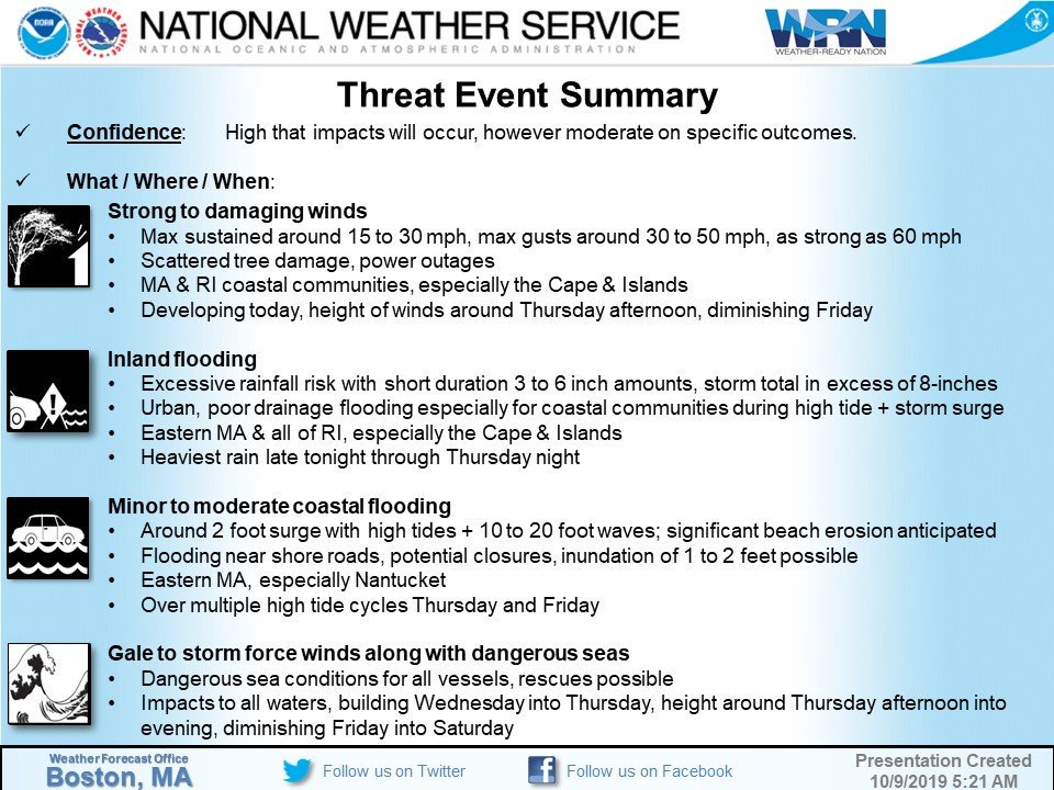
STORM OVERVIEW …
Long duration, ocean storm / Nor'Easter will continue to bring strong to damaging winds, periods of moderate to heavy rain, inland & coastal flood threats, as well as rough boating conditions through Friday. pic.twitter.com/hnbPuKPubo
— NWS Boston (@NWSBoston) October 10, 2019
Thanks Colleen! High surf & significant beach erosion are the main issues for the eastern MA coast, along with minor coastal flooding from Boston to Cape Cod. https://t.co/bbPlxE31Uf
— NWS Boston (@NWSBoston) October 10, 2019
[#Noreaster] Convection (#thunderstorms – taller clouds) firing on northwest side of ocean storm well south of #Nantucket. Meanwhile on the backside of the storm enough dry air promoting some sunshine across western portions of #MA #CT into #NY pic.twitter.com/hr4yw4uERQ
— NWS Boston (@NWSBoston) October 10, 2019
Big #waves from the early season nor’easter breaking this afternoon on East Matunuck Beach #RI. #noreaster #StormHour @Ginger_Zee @JimCantore @ericfisher @TimNBCBoston @Ginger_Zee @RachelFrank_CT @ryanhanrahan pic.twitter.com/xfD33ApdY9
— eweather (@Eweather13) October 10, 2019
[#Noreaster] Ocean storm tracking farther south than previously thought so less rainfall expected thru Friday. However strong winds with isolated outages will continue to impact #CapeCod & the Islands thru tonight along with minor-moderate coastal flooding especially #Nantucket pic.twitter.com/LZ8aNF4HdS
— NWS Boston (@NWSBoston) October 10, 2019
The storm will continue to bring heavy rainfall and gusty winds to extreme southeastern New England on Friday, October 11, NWS forecaster Santorelli notes.
An additional 25 mm (1 inch) of rainfall is still possible before the rain begins tapering off on Saturday as the low finally drifts away from the coast.
Meanwhile, an early-season major winter storm continues across the Northern Plains as an anomalously cold air mass drops into the Central U.S. and interacts with a vigorous storm system.
Heavy snowfall across the Northern Plains will continue Friday into Saturday as the storm system is slow to exit the region. The heaviest axis should focus across eastern North Dakota where an additional 30 – 60 cm (1 to 2 feet) of snow is expected.
Strong and gusty winds will accompany this system resulting in blowing snow and dangerous travel.
Blizzard warnings are in effect across portions of north-central North Dakota. A very cold air mass has spread across the Western U.S. and into the Plains, and widespread record lows remain likely again on Friday morning for many locations from the Southern/Central Plains to the Great Basin.
Along and ahead of the sharp cold front from the Mississippi Valley to the Ohio Valley, heavy rainfall is possible on Friday, though the front will be progressive enough to limit a widespread flash flood threat.
Critical to extremely critical fire weather conditions will continue on Friday across portions of Southern California due to gusty winds and a very dry airmass. These conditions should subside by the weekend as an upper level trough approaches the region.
The setup has already resulted in mandatory evacuations as Saddleridge Fire, which broke out late October 10, exploded amid windy weather. There are approximately 1 900 homes within the mandatory evacuation zone as of early October 11 (LT).
The fire jumped a portion of Interstate 5, and is rapidly moving toward the northern portions of Granada Hills, Porter Ranch and Chatsworth, in the vicinity of the 118 freeway.
"Be prepared and ready to evacuate if given the order," LAPD said.
#BREAKING: The #SaddleridgeFire has completely consumed the 5 freeway in the #newhall pass… MAJOR FIRE EMERGENCY #losangeles @abc7 #abc7eyewitness pic.twitter.com/kSmr7EExT0
— Chris Cristi (@abc7chriscristi) October 11, 2019
I'm a dedicated researcher, journalist, and editor at The Watchers. With over 20 years of experience in the media industry, I specialize in hard science news, focusing on extreme weather, seismic and volcanic activity, space weather, and astronomy, including near-Earth objects and planetary defense strategies. You can reach me at teo /at/ watchers.news.
Commenting rules and guidelines
We value the thoughts and opinions of our readers and welcome healthy discussions on our website. In order to maintain a respectful and positive community, we ask that all commenters follow these rules.