
Lorenzo becomes the strongest hurricane this far north and east in the Atlantic basin

Featured image: Hurricane "Lorenzo" at 18:00 UTC on September 29, 2019. Credit: NOAA/GOES-East
Lorenzo rapidly strengthened into a Category 5 hurricane on September 28 and 29, 2019, and became the strongest hurricane this far north and east in the Atlantic basin on record. There are no coastal watches or warnings in effect but interests in the Azores should monitor the progress of the system as Lorenzo is expected to be a large and potent hurricane as is approaches the islands in a few days.
At 03:00 UTC on September 29, the center of Hurricane "Lorenzo" was located 2 285 km (1 420 miles) SE of the Azores. Its maximum sustained winds were 260 km/h (10 mph). The system is moving N at 17 km/h (10 mph) with minimum central pressure of 925 hPa.
A turn to the north-northeast is expected on Sunday, followed by a turn to the northeast by Monday. A faster northeast motion is expected by Tuesday.
A turn to the north-northeast is expected on Sunday, followed by a turn to the northeast by Monday. A faster northeast motion is expected by Tuesday. Some fluctuations in intensity are possible through Sunday. A weakening trend is forecast to begin Sunday night. However, Lorenzo is expected to be a large and potent hurricane as is approaches the Azores in a few days.

Swells generated by Lorenzo are affecting portions of the northeastern coast of South America and the Lesser Antilles and are expected to spread westward to portions of the north coasts of the Greater Antilles, the Bahamas, Bermuda, and the east coast of the United States during the next few days. Swells are also expected to build near the Azores on Sunday and Monday. These swells are likely to cause life-threatening surf and rip current conditions.

Hurricane "Lorenzo" at 18:00 UTC on September 29, 2019. Credit: NOAA/GOES-East
Lorenzo has already generated the 9th most Accumulated Cyclone Energy by an Atlantic hurricane east of 45°W in satellite era (since 1966), CSU meteorologist Dr. Philip Klotzbach said September 27. "Given National Hurricane Center track and intensity forecast for Lorenzo, it may surpass the current record holder: Frances 1980."
Here are some more interesting statistics provided by Dr. Klotzbach:
Lorenzo has been a major (Category 3+) hurricane east of 45°W for 2 days – the most major hurricane days by an Atlantic hurricane east of 45°W on record. This breaks the old Atlantic record set by Hurricane "Carrie" of 1.75 days set in 1957.
By September 29, Lorenzo has surpassed Humberto for 2nd place for 2019 Atlantic Accumulated Cyclone Energy by a hurricane. However, Dorian will retain the top spot, since Lorenzo will become post-tropical in 4-5 days.
2019 is the 7th Atlantic hurricane season on record with at least 2 Category 5 hurricanes. Other years are 1932, 1933, 1961, 2005, 2007, and 2017. 2019's Category 5 hurricanes are Dorian and Lorenzo.
Lorenzo's current central pressure of 925 hPa is the lowest by any Atlantic #hurricane east of 50°W on record. Prior record was 933 hPa by Edouard (1996), Gert (1999) and Igor (2010).
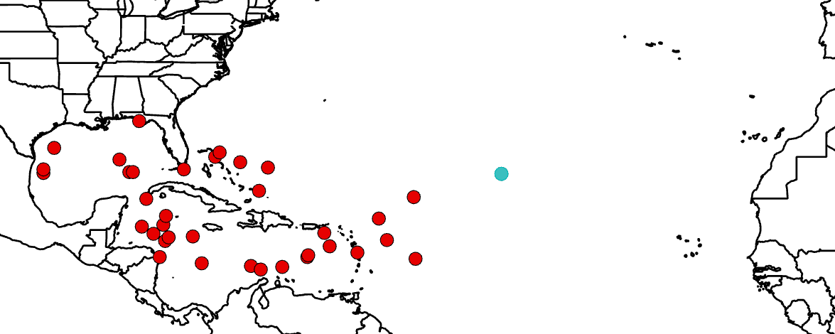
Image credit: Philip Klotzbach

Teo Blašković founded The Watchers in 2011 and edited it until 2026, covering seismic and volcanic activity, extreme weather, space weather and near-Earth objects. Articles on this page are his archive.
Published in the last 24 hours
- In September 1859, a solar storm lit up the night sky so brightly that gold miners in the Rocky Mountains woke up after midnight and started cooking breakfast, convinced the aurora glowing over their camp was the sunrise Epicenter
- A patch of warm Pacific water that could become the strongest El Niño in more than 70 years sits thousands of miles from any American town, yet it is already the main reason NOAA expects a wetter winter across the South and a milder one across the North
- A 19-year-old Nebraska teacher reportedly tied her pupils together with twine and led them to safety through a blizzard in January 1888 Epicenter
