
Tropical Storm “Erin” forms off the coast of North Carolina, Dorian nears Virgin Islands and Puerto Rico
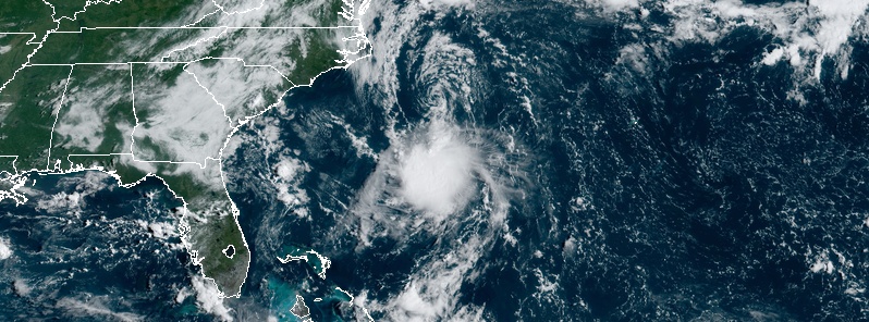
Featured image: Tropical Storm "Erin" at 14:00 UTC on August 28, 2019. Credit: NOAA/GOES-East
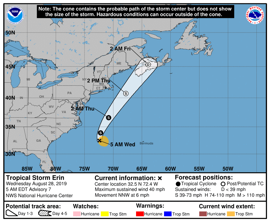
Tropical Storm "Erin" formed off the coast of North Carolina, U.S. at 03:00 UTC on August 28, 2019 as the 5th named storm of the 2019 Atlantic hurricane season. Some slight strengthening is possible today, but the system will gradually weaken Thursday as it completes a transition to an extratropical cyclone. Meanwhile, Tropical Storm "Dorian" is nearing the Virgin Islands and Puerto Rico. Uncertainty in the intensity forecast late this week remains higher than usual due to a large spread in the model guidance.
At 09:00 UTC on August 28, the center of Tropical Storm "Erin" was located about 705 km (435 miles) W of Bermuda and 430 km (265 miles) SE of Cape Hatteras, North Carolina.
Its maximum sustained winds were 65 km/h (40 mph) and minimum central pressure 1 005 hPa.
The system is moving NNW at 9 km/h (6 mph).
A turn northward is expected later today followed by a turn NNE early Thursday, August 29 (EDT) with an increase in forward speed.
Some slight strengthening is possible today, but Erin is forecast to weaken Thursday as it completes a transition to an extratropical cyclone.
"Statistical-dynamical intensity guidance show that the shear should diminish somewhat today while the system remains over warm oceanic sea surface temperatures. This should allow for some slight strengthening at that time. Thereafter, baroclinic processes associated with the aforementioned mid-latitude trough and significantly decreasing sea surface temperatures should cause Erin to acquire extratropical characteristics, and complete the transition in 36 hours, as the Florida State Cyclone Phase Evolution forecast and global models unanimously predict," NWS forecaster Roberts noted.
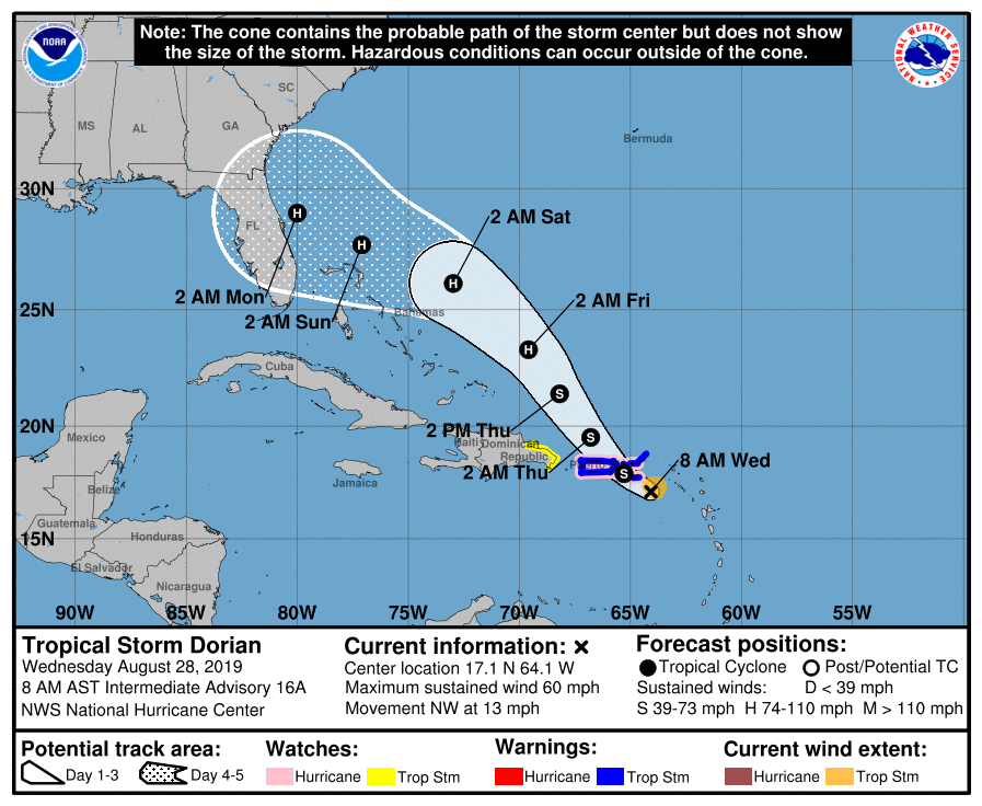
Meanwhile, Tropical Storm "Dorian" is nearing the Virgin Islands and Puerto Rico.
A Hurricane Watch is in effect for:
- Puerto Rico
- Vieques
- Culebra
- U.S. Virgin Islands
A Tropical Storm Warning is in effect for:
- Puerto Rico
- Vieques
- Culebra
- U.S. Virgin Islands
- British Virgin Islands
A Tropical Storm Watch is in effect for:
- Dominican Republic from Isla Saona to Samana
Dorian is moving toward the northwest near 20 km/h (13 mph), and this general motion is expected to continue during the next few days.
On the forecast track, the center of Dorian will pass over or near the U.S. and the British Virgin Islands and Puerto Rico later today.
Dorian is then forecast to move to the east of the Turks and Caicos and the southeastern Bahamas on Thursday, and near or to the east of the central and northwestern Bahamas on Friday and Saturday.
Maximum sustained winds are near 95 km/h (60 mph) with higher gusts.
Some strengthening is expected today, and Dorian is forecast to be near hurricane strength when it approaches the Virgin Islands and Puerto Rico.
Although weakening is possible after Dorian moves across Puerto Rico and the Virgin Islands, the storm is forecast to strengthen late this week and this weekend while passing near or to the east of the Turks and Caicos and the Bahamas.
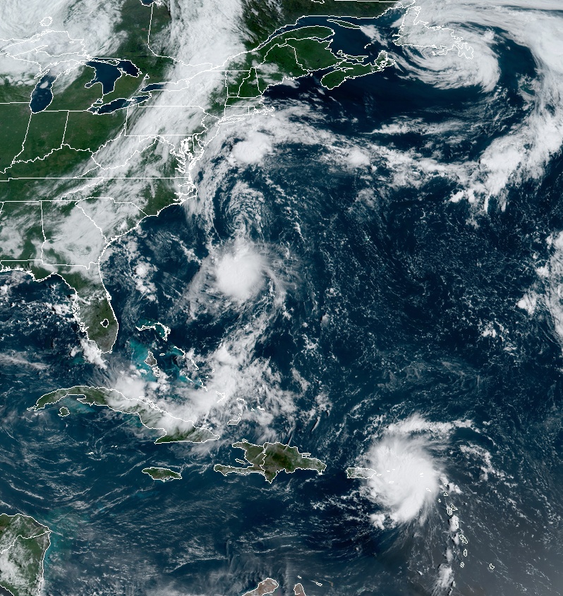
Tropical Storms "Erin" and "Dorian" at 14:00 UTC on August 28, 2019. Credit: NOAA/GOES-East
Key messages:
1. Tropical storm conditions are expected in the U.S. and British Virgin Islands and Puerto Rico today, and are possible in portions of the Dominican Republic tonight and Thursday. Hurricane conditions are possible in Puerto Rico and the U.S. Virgin Islands today.
2. Heavy rainfall over portions of Puerto Rico and the U.S. and British Virgin Islands could produce flash flooding during the next couple of days. Heavy rains are expected to occur over portions of the Bahamas and Florida later this week and into early next week.
3. The threat of tropical storm or hurricane conditions, along with storm surge, in the northwestern Bahamas and along portions of the Florida east coast have increased. Residents in these areas should monitor the progress of Dorian and ensure that they have their hurricane plan in place.
4. Uncertainty in the intensity forecast late this week remains higher than usual due to a large spread in the model guidance.
Forecast models
I'm a dedicated researcher, journalist, and editor at The Watchers. With over 20 years of experience in the media industry, I specialize in hard science news, focusing on extreme weather, seismic and volcanic activity, space weather, and astronomy, including near-Earth objects and planetary defense strategies. You can reach me at teo /at/ watchers.news.
Commenting rules and guidelines
We value the thoughts and opinions of our readers and welcome healthy discussions on our website. In order to maintain a respectful and positive community, we ask that all commenters follow these rules.